-
Evapotranspiration réelle pour l'Australie (CMRSET Landsat V2.2)
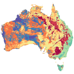
Cet ensemble de données fournit une estimation précise de l'évapotranspiration réelle (AET ou ETa) pour l'Australie à l'aide de l'algorithme CMRSET. La bande AET (nommée "ETa") contient la valeur quotidienne moyenne du modèle CMRSET pour toutes les observations Landsat sans nuage de ce mois (indiquée par la valeur 3 dans les données AET). agriculture Australie CSIRO évaporation évaporation-transpiration dérivé de Landsat -
SLGA: Soil and Landscape Grid of Australia (Soil Attributes)
La grille des sols et des paysages de l'Australie (SLGA) est un ensemble de données complet sur les attributs des sols de l'Australie, avec une résolution de trois secondes d'arc (~90 m de pixel). Les surfaces sont les résultats de la modélisation qui décrivent la distribution spatiale des attributs du sol à l'aide de données existantes sur le sol et sur l'environnement. Australie CSIRO sol tern
Datasets tagged tern in Earth Engine
[null,null,[],[[["\u003cp\u003eThe Soil and Landscape Grid of Australia (SLGA) dataset provides comprehensive soil attribute information for Australia at ~90m resolution.\u003c/p\u003e\n"],["\u003cp\u003eThe Actual Evapotranspiration for Australia dataset offers daily evapotranspiration estimates derived from cloud-free Landsat observations using the CMRSET algorithm.\u003c/p\u003e\n"]]],[],null,["# Datasets tagged tern in Earth Engine\n\n-\n\n |-------------------------------------------------------------------------------------------------------------------------------------------------------------------------------------------------------------------------------------------------------------------------------------------------------------------------------------------------|\n | [### Actual Evapotranspiration for Australia (CMRSET Landsat V2.2)](/earth-engine/datasets/catalog/TERN_AET_CMRSET_LANDSAT_V2_2) |\n | This dataset provides accurate actual evapotranspiration (AET or ETa) for Australia using the CMRSET algorithm. The AET band (named 'ETa') contains the average daily value from the CMRSET model for all cloud-free Landsat observations in that month (indicated with value 3 in the AET Data ... |\n | [agriculture](/earth-engine/datasets/tags/agriculture) [australia](/earth-engine/datasets/tags/australia) [csiro](/earth-engine/datasets/tags/csiro) [evaporation](/earth-engine/datasets/tags/evaporation) [evapotranspiration](/earth-engine/datasets/tags/evapotranspiration) [landsat-derived](/earth-engine/datasets/tags/landsat-derived) |\n\n-\n\n |---------------------------------------------------------------------------------------------------------------------------------------------------------------------------------------------------------------------------------------------------------------------------------------------------------------------|\n | [### SLGA: Soil and Landscape Grid of Australia (Soil Attributes)](/earth-engine/datasets/catalog/CSIRO_SLGA) |\n | The Soil and Landscape Grid of Australia (SLGA) is a comprehensive dataset of soil attributes across Australia at 3 arc-second resolution (\\~90m pixels). The surfaces are the outcomes from modelling that describe the spatial distribution of the soil attributes using existing soil data and environmental ... |\n | [australia](/earth-engine/datasets/tags/australia) [csiro](/earth-engine/datasets/tags/csiro) [soil](/earth-engine/datasets/tags/soil) [tern](/earth-engine/datasets/tags/tern) |"]]