-
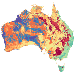
Avustralya için gerçek buharlaşma (CMRSET Landsat V2.2)
Bu veri kümesi, CMRSET algoritmasını kullanarak Avustralya için gerçek buharlaşma (AET veya ETa) değerlerini doğru şekilde sağlar. AET bandı ("ETa" olarak adlandırılır), ilgili aydaki tüm bulutsuz Landsat gözlemleri için CMRSET modelinden elde edilen ortalama günlük değeri içerir (AET Verileri bölümünde 3 değeriyle gösterilir). agriculture australia csiro evaporation evapotranspiration landsat-derived -
SLGA: Avustralya'nın Toprak ve Peyzaj Gribi (Toprak Özellikleri)
Avustralya Toprak ve Peyzaj Gribi (SLGA), 3 yay saniyelik çözünürlükte (~90 m piksel) Avustralya'daki toprak özelliklerini içeren kapsamlı bir veri kümesidir. Yüzeyler, mevcut toprak verileri ve çevresel verileri kullanarak toprak özelliklerinin mekansal dağılımını tanımlayan modelleme sonuçlarından oluşur. australia csiro soil tern
Datasets tagged tern in Earth Engine
[null,null,[],[[["\u003cp\u003eThe Soil and Landscape Grid of Australia (SLGA) dataset provides comprehensive soil attribute information for Australia at ~90m resolution.\u003c/p\u003e\n"],["\u003cp\u003eThe Actual Evapotranspiration for Australia dataset offers daily evapotranspiration estimates derived from cloud-free Landsat observations using the CMRSET algorithm.\u003c/p\u003e\n"]]],[],null,["# Datasets tagged tern in Earth Engine\n\n-\n\n |-------------------------------------------------------------------------------------------------------------------------------------------------------------------------------------------------------------------------------------------------------------------------------------------------------------------------------------------------|\n | [### Actual Evapotranspiration for Australia (CMRSET Landsat V2.2)](/earth-engine/datasets/catalog/TERN_AET_CMRSET_LANDSAT_V2_2) |\n | This dataset provides accurate actual evapotranspiration (AET or ETa) for Australia using the CMRSET algorithm. The AET band (named 'ETa') contains the average daily value from the CMRSET model for all cloud-free Landsat observations in that month (indicated with value 3 in the AET Data ... |\n | [agriculture](/earth-engine/datasets/tags/agriculture) [australia](/earth-engine/datasets/tags/australia) [csiro](/earth-engine/datasets/tags/csiro) [evaporation](/earth-engine/datasets/tags/evaporation) [evapotranspiration](/earth-engine/datasets/tags/evapotranspiration) [landsat-derived](/earth-engine/datasets/tags/landsat-derived) |\n\n-\n\n |---------------------------------------------------------------------------------------------------------------------------------------------------------------------------------------------------------------------------------------------------------------------------------------------------------------------|\n | [### SLGA: Soil and Landscape Grid of Australia (Soil Attributes)](/earth-engine/datasets/catalog/CSIRO_SLGA) |\n | The Soil and Landscape Grid of Australia (SLGA) is a comprehensive dataset of soil attributes across Australia at 3 arc-second resolution (\\~90m pixels). The surfaces are the outcomes from modelling that describe the spatial distribution of the soil attributes using existing soil data and environmental ... |\n | [australia](/earth-engine/datasets/tags/australia) [csiro](/earth-engine/datasets/tags/csiro) [soil](/earth-engine/datasets/tags/soil) [tern](/earth-engine/datasets/tags/tern) |"]]