-
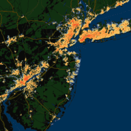
YCEO เกาะความร้อนในเมืองบริเวณพื้นผิว: ระดับความเข้มของช่วงกลางวันและกลางคืนรายปีระดับพิกเซล
ชุดข้อมูลนี้มีความรุนแรงของเกาะความร้อนบนพื้นผิวของเมือง (SUHI) ในช่วงกลางวันและกลางคืนตลอดทั้งปี ช่วงฤดูร้อน และช่วงฤดูหนาวสำหรับกลุ่มเมืองกว่า 10,000 แห่งทั่วโลก ชุดข้อมูลนี้สร้างขึ้นโดยใช้ผลิตภัณฑ์อุณหภูมิพื้นผิวดิน (LST) ของ TERRA และ AQUA ของ MODIS 8 วัน, ขอบเขตเมืองของ Landscan … climate uhi urban yale -
เกาะความร้อนในเมืองบนพื้นผิว YCEO: ภาพรวมระดับพิกเซลของช่วงกลางวันและกลางคืนในฤดูร้อนประจำปี
ชุดข้อมูลนี้มีความรุนแรงของเกาะความร้อนบนพื้นผิวของเมือง (SUHI) ในช่วงกลางวันและกลางคืนตลอดทั้งปี ช่วงฤดูร้อน และช่วงฤดูหนาวสำหรับกลุ่มเมืองกว่า 10,000 แห่งทั่วโลก ชุดข้อมูลนี้สร้างขึ้นโดยใช้ผลิตภัณฑ์อุณหภูมิพื้นผิวดิน (LST) ของ TERRA และ AQUA ของ MODIS 8 วัน, ขอบเขตเมืองของ Landscan … climate uhi urban yale -
เกาะความร้อนในเมืองระดับพื้นผิวของ YCEO: ภาพรวมรายปีระดับพิกเซลของช่วงกลางวันและกลางคืนในฤดูหนาว
ชุดข้อมูลนี้มีความรุนแรงของเกาะความร้อนบนพื้นผิวของเมือง (SUHI) ในช่วงกลางวันและกลางคืนตลอดทั้งปี ช่วงฤดูร้อน และช่วงฤดูหนาวสำหรับกลุ่มเมืองกว่า 10,000 แห่งทั่วโลก ชุดข้อมูลนี้สร้างขึ้นโดยใช้ผลิตภัณฑ์อุณหภูมิพื้นผิวดิน (LST) ของ TERRA และ AQUA ของ MODIS 8 วัน, ขอบเขตเมืองของ Landscan … climate uhi urban yale -
เกาะความร้อนในเมืองบริเวณพื้นผิวของ YCEO: ความรุนแรงในช่วงกลางวันและกลางคืนที่เฉลี่ยตามพื้นที่สำหรับทั้งปี ฤดูร้อน และฤดูหนาว
ชุดข้อมูลนี้มีความรุนแรงของเกาะความร้อนบนพื้นผิวของเมือง (SUHI) ในช่วงกลางวันและกลางคืนตลอดทั้งปี ช่วงฤดูร้อน และช่วงฤดูหนาวสำหรับกลุ่มเมืองกว่า 10,000 แห่งทั่วโลก ชุดข้อมูลนี้สร้างขึ้นโดยใช้ผลิตภัณฑ์อุณหภูมิพื้นผิวดิน (LST) ของ TERRA และ AQUA ของ MODIS 8 วัน, ขอบเขตเมืองของ Landscan … climate uhi urban yale -
เกาะความร้อนในเมืองบนพื้นผิวของ YCEO: ภาพรวมของระดับความเข้มในช่วงกลางวันและกลางคืนที่เฉลี่ยตามพื้นที่ในแต่ละเดือน
ชุดข้อมูลนี้มีความรุนแรงของเกาะความร้อนบนพื้นผิวของเมือง (SUHI) ในช่วงกลางวันและกลางคืนตลอดทั้งปี ช่วงฤดูร้อน และช่วงฤดูหนาวสำหรับกลุ่มเมืองกว่า 10,000 แห่งทั่วโลก ชุดข้อมูลนี้สร้างขึ้นโดยใช้ผลิตภัณฑ์อุณหภูมิพื้นผิวดิน (LST) ของ TERRA และ AQUA ของ MODIS 8 วัน, ขอบเขตเมืองของ Landscan … climate uhi urban yale -
เกาะความร้อนในเมืองบริเวณพื้นผิวของ YCEO: ภาพรวมประจำปีที่เฉลี่ยตามพื้นที่ของระดับความรุนแรงในช่วงกลางวันและกลางคืน
ชุดข้อมูลนี้มีความรุนแรงของเกาะความร้อนบนพื้นผิวของเมือง (SUHI) ในช่วงกลางวันและกลางคืนตลอดทั้งปี ช่วงฤดูร้อน และช่วงฤดูหนาวสำหรับกลุ่มเมืองกว่า 10,000 แห่งทั่วโลก ชุดข้อมูลนี้สร้างขึ้นโดยใช้ผลิตภัณฑ์อุณหภูมิพื้นผิวดิน (LST) ของ TERRA และ AQUA ของ MODIS 8 วัน, ขอบเขตเมืองของ Landscan … climate uhi urban yale
Datasets tagged uhi in Earth Engine
[null,null,[],[[["\u003cp\u003eThis collection of datasets provides surface urban heat island (SUHI) intensities for over 10,000 urban clusters globally.\u003c/p\u003e\n"],["\u003cp\u003eThe datasets offer various temporal resolutions, including annual, seasonal (summer and winter), and monthly composites.\u003c/p\u003e\n"],["\u003cp\u003eSUHI intensities are available for both daytime and nighttime periods.\u003c/p\u003e\n"],["\u003cp\u003eData is derived from MODIS land surface temperature products and Landscan urban extent data.\u003c/p\u003e\n"],["\u003cp\u003eThese datasets are valuable for studying the urban heat island effect and its impacts on climate and urban environments.\u003c/p\u003e\n"]]],["The YCEO datasets provide surface urban heat island (SUHI) intensities for over 10,000 urban clusters globally. Data includes annual, summertime, and wintertime intensities, for both day and night. The information is derived from MODIS land surface temperature products and Landscan urban extent data. The datasets offer both pixel-level and spatially-averaged intensity composites, including yearly and monthly averages. These are for the annual, summer, and winter time, as well as for daytime and nighttime.\n"],null,["# Datasets tagged uhi in Earth Engine\n\n-\n\n |------------------------------------------------------------------------------------------------------------------------------------------------------------------------------------------------------------------------------------------------------------------------------------------------------------------|\n | [### YCEO Surface Urban Heat Islands: Pixel-Level Annual Daytime and Nighttime Intensity](/earth-engine/datasets/catalog/YALE_YCEO_UHI_UHI_yearly_pixel_v4) |\n | This dataset contains annual, summertime, and wintertime surface urban heat island (SUHI) intensities for day and night for over 10,000 urban clusters throughout the world. The dataset was created using the MODIS 8-day TERRA and AQUA land surface temperature (LST) products, the Landscan urban extent ... |\n | [climate](/earth-engine/datasets/tags/climate) [uhi](/earth-engine/datasets/tags/uhi) [urban](/earth-engine/datasets/tags/urban) [yale](/earth-engine/datasets/tags/yale) |\n\n-\n\n |------------------------------------------------------------------------------------------------------------------------------------------------------------------------------------------------------------------------------------------------------------------------------------------------------------------|\n | [### YCEO Surface Urban Heat Islands: Pixel-Level Composites of Yearly Summertime Daytime and Nighttime Intensity](/earth-engine/datasets/catalog/YALE_YCEO_UHI_Summer_UHI_yearly_pixel_v4) |\n | This dataset contains annual, summertime, and wintertime surface urban heat island (SUHI) intensities for day and night for over 10,000 urban clusters throughout the world. The dataset was created using the MODIS 8-day TERRA and AQUA land surface temperature (LST) products, the Landscan urban extent ... |\n | [climate](/earth-engine/datasets/tags/climate) [uhi](/earth-engine/datasets/tags/uhi) [urban](/earth-engine/datasets/tags/urban) [yale](/earth-engine/datasets/tags/yale) |\n\n-\n\n |------------------------------------------------------------------------------------------------------------------------------------------------------------------------------------------------------------------------------------------------------------------------------------------------------------------|\n | [### YCEO Surface Urban Heat Islands: Pixel-Level Yearly Composites of Wintertime Daytime and Nighttime Intensity](/earth-engine/datasets/catalog/YALE_YCEO_UHI_Winter_UHI_yearly_pixel_v4) |\n | This dataset contains annual, summertime, and wintertime surface urban heat island (SUHI) intensities for day and night for over 10,000 urban clusters throughout the world. The dataset was created using the MODIS 8-day TERRA and AQUA land surface temperature (LST) products, the Landscan urban extent ... |\n | [climate](/earth-engine/datasets/tags/climate) [uhi](/earth-engine/datasets/tags/uhi) [urban](/earth-engine/datasets/tags/urban) [yale](/earth-engine/datasets/tags/yale) |\n\n-\n\n |------------------------------------------------------------------------------------------------------------------------------------------------------------------------------------------------------------------------------------------------------------------------------------------------------------------|\n | [### YCEO Surface Urban Heat Islands: Spatially-Averaged Daytime and Nighttime Intensity for Annual, Summer, and Winter](/earth-engine/datasets/catalog/YALE_YCEO_UHI_UHI_all_averaged_v4) |\n | This dataset contains annual, summertime, and wintertime surface urban heat island (SUHI) intensities for day and night for over 10,000 urban clusters throughout the world. The dataset was created using the MODIS 8-day TERRA and AQUA land surface temperature (LST) products, the Landscan urban extent ... |\n | [climate](/earth-engine/datasets/tags/climate) [uhi](/earth-engine/datasets/tags/uhi) [urban](/earth-engine/datasets/tags/urban) [yale](/earth-engine/datasets/tags/yale) |\n\n-\n\n |------------------------------------------------------------------------------------------------------------------------------------------------------------------------------------------------------------------------------------------------------------------------------------------------------------------|\n | [### YCEO Surface Urban Heat Islands: Spatially-Averaged Monthly Composites of Daytime and Nighttime Intensity](/earth-engine/datasets/catalog/YALE_YCEO_UHI_UHI_monthly_averaged_v4) |\n | This dataset contains annual, summertime, and wintertime surface urban heat island (SUHI) intensities for day and night for over 10,000 urban clusters throughout the world. The dataset was created using the MODIS 8-day TERRA and AQUA land surface temperature (LST) products, the Landscan urban extent ... |\n | [climate](/earth-engine/datasets/tags/climate) [uhi](/earth-engine/datasets/tags/uhi) [urban](/earth-engine/datasets/tags/urban) [yale](/earth-engine/datasets/tags/yale) |\n\n-\n\n |------------------------------------------------------------------------------------------------------------------------------------------------------------------------------------------------------------------------------------------------------------------------------------------------------------------|\n | [### YCEO Surface Urban Heat Islands: Spatially-Averaged Yearly Composites of Annual Daytime and Nighttime Intensity](/earth-engine/datasets/catalog/YALE_YCEO_UHI_UHI_yearly_averaged_v4) |\n | This dataset contains annual, summertime, and wintertime surface urban heat island (SUHI) intensities for day and night for over 10,000 urban clusters throughout the world. The dataset was created using the MODIS 8-day TERRA and AQUA land surface temperature (LST) products, the Landscan urban extent ... |\n | [climate](/earth-engine/datasets/tags/climate) [uhi](/earth-engine/datasets/tags/uhi) [urban](/earth-engine/datasets/tags/urban) [yale](/earth-engine/datasets/tags/yale) |"]]