-
GLCF: Landsat Global Inland Water
Il set di dati sulle acque interne globali mostra i corpi idrici interni, inclusi laghi, fiumi e bacini idrici dolci e salini. Dall'epoca GLS 2000 sono stati identificati 3.650.723 km2 di acque interne, circa tre quarti dei quali in Nord America e Asia. Foreste boreali e tundra … glcf landsat-derived nasa surface-ground-water umd water -
Copertura arborea multiannuale globale a 30 m del Global Forest Cover Change (GFCC)
I livelli di copertura degli alberi dei campi continui della vegetazione (VCF) di Landsat contengono stime della percentuale di terreno orizzontale in ogni pixel di 30 m coperto da vegetazione legnosa di altezza superiore a 5 metri. Il set di dati è disponibile per quattro epoche centrate sugli anni 2000, 2005, 2010 e così via. forest forest-biomass glcf landsat-derived nasa umd -
Hansen Global Forest Change v1.12 (2000-2024)
Risultati dell'analisi delle serie temporali delle immagini Landsat per la caratterizzazione dell'estensione e del cambiamento delle foreste a livello globale. Le bande "prima" e "ultima" sono immagini multispettrali di riferimento del primo e dell'ultimo anno disponibile per le bande spettrali di Landsat corrispondenti a rosso, NIR, SWIR1 e SWIR2. Le immagini composite di riferimento rappresentano… forest biomassa-foresta geofisica derivata-landsat umd -
Foreste tropicali umide primarie
Le foreste tropicali umide primarie forniscono numerosi servizi ecosistemici globali, ma sono costantemente minacciate da abbattimenti per motivi economici. Per facilitare la pianificazione dell'uso del suolo a livello nazionale e bilanciare gli obiettivi di sviluppo economico e mantenimento dei servizi ecosistemici, è stata creata una mappa principale delle foreste tropicali umide … forest forest-biomass global landsat-derived umd -
WHRC Pantropical Pantropical National Level Carbon Stock Dataset
Una mappa a livello nazionale della densità della biomassa legnosa sopra il suolo per i paesi tropicali a 500 m. Questo set di dati è stato assemblato da una combinazione di misurazioni sul campo co-localizzate, osservazioni LiDAR e immagini registrate dallo spettroradiometro ottico ad alta risoluzione (MODIS). sopraelevata biomassa carbonio biomassa forestale geofisica umd
Datasets tagged umd in Earth Engine
[null,null,[],[[["\u003cp\u003eThis webpage provides access to various datasets related to global forest cover, tree cover, and biomass.\u003c/p\u003e\n"],["\u003cp\u003eDatasets offer insights into forest change, including deforestation and primary forest identification.\u003c/p\u003e\n"],["\u003cp\u003eInformation on global inland water bodies, such as lakes and rivers, is also available.\u003c/p\u003e\n"],["\u003cp\u003eData is derived from sources like Landsat and MODIS imagery, offering high-resolution observations.\u003c/p\u003e\n"],["\u003cp\u003eThese datasets support research on carbon stock, land use planning, and ecosystem services.\u003c/p\u003e\n"]]],[],null,["# Datasets tagged umd in Earth Engine\n\n-\n\n |-------------------------------------------------------------------------------------------------------------------------------------------------------------------------------------------------------------------------------------------------------------------------------------------------------------|\n | [### GLCF: Landsat Global Inland Water](/earth-engine/datasets/catalog/GLCF_GLS_WATER) |\n | The Global Inland Water dataset shows inland surface water bodies, including fresh and saline lakes, rivers, and reservoirs. From the GLS 2000 epoch, 3,650,723 km2 of inland water were identified, around three quarters of which were in North America and Asia. Boreal forests and tundra ... |\n | [glcf](/earth-engine/datasets/tags/glcf) [landsat-derived](/earth-engine/datasets/tags/landsat-derived) [nasa](/earth-engine/datasets/tags/nasa) [surface-ground-water](/earth-engine/datasets/tags/surface-ground-water) [umd](/earth-engine/datasets/tags/umd) [water](/earth-engine/datasets/tags/water) |\n\n-\n\n |---------------------------------------------------------------------------------------------------------------------------------------------------------------------------------------------------------------------------------------------------------------------------------------------------|\n | [### Global Forest Cover Change (GFCC) Tree Cover Multi-Year Global 30m
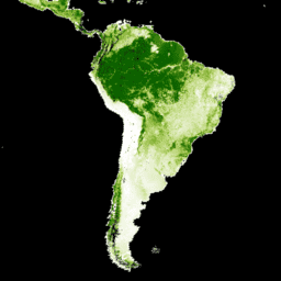
](/earth-engine/datasets/catalog/NASA_MEASURES_GFCC_TC_v3) |\n | The Landsat Vegetation Continuous Fields (VCF) tree cover layers contain estimates of the percentage of horizontal ground in each 30-m pixel covered by woody vegetation greater than 5 meters in height. The dataset is available for four epochs centered on the years 2000, 2005, 2010 ... |\n | [forest](/earth-engine/datasets/tags/forest) [forest-biomass](/earth-engine/datasets/tags/forest-biomass) [glcf](/earth-engine/datasets/tags/glcf) [landsat-derived](/earth-engine/datasets/tags/landsat-derived) [nasa](/earth-engine/datasets/tags/nasa) [umd](/earth-engine/datasets/tags/umd) |\n\n-\n\n |------------------------------------------------------------------------------------------------------------------------------------------------------------------------------------------------------------------------------------------------------------------------------------------------------------------------------------|\n | [### Hansen Global Forest Change v1.12 (2000-2024)](/earth-engine/datasets/catalog/UMD_hansen_global_forest_change_2024_v1_12) |\n | Results from time-series analysis of Landsat images in characterizing global forest extent and change. The 'first' and 'last' bands are reference multispectral imagery from the first and last available years for Landsat spectral bands corresponding to red, NIR, SWIR1, and SWIR2. Reference composite imagery represents ... |\n | [forest](/earth-engine/datasets/tags/forest) [forest-biomass](/earth-engine/datasets/tags/forest-biomass) [geophysical](/earth-engine/datasets/tags/geophysical) [landsat-derived](/earth-engine/datasets/tags/landsat-derived) [umd](/earth-engine/datasets/tags/umd) |\n\n-\n\n |-----------------------------------------------------------------------------------------------------------------------------------------------------------------------------------------------------------------------------------------------------------------------------------------------------------------------------------|\n | [### Primary Humid Tropical Forests](/earth-engine/datasets/catalog/UMD_GLAD_PRIMARY_HUMID_TROPICAL_FORESTS_v1) |\n | Primary humid tropical forests provide numerous global ecosystem services, but are under continuing threat of clearing from economic drivers. To facilitate national land use planning and balancing the goals of economic development and maintenance of ecosystem services, a primary humid tropical forest map was created ... |\n | [forest](/earth-engine/datasets/tags/forest) [forest-biomass](/earth-engine/datasets/tags/forest-biomass) [global](/earth-engine/datasets/tags/global) [landsat-derived](/earth-engine/datasets/tags/landsat-derived) [umd](/earth-engine/datasets/tags/umd) |\n\n-\n\n |---------------------------------------------------------------------------------------------------------------------------------------------------------------------------------------------------------------------------------------------------------------------------------------------------------------|\n | [### WHRC Pantropical National Level Carbon Stock Dataset](/earth-engine/datasets/catalog/WHRC_biomass_tropical) |\n | A national-level map of above-ground live woody biomass density for tropical countries at 500m. This dataset was assembled from a combination of co-located field measurements, LiDAR observations, and imagery recorded from the Moderate Resolution Imaging Spectroradiometer (MODIS). |\n | [aboveground](/earth-engine/datasets/tags/aboveground) [biomass](/earth-engine/datasets/tags/biomass) [carbon](/earth-engine/datasets/tags/carbon) [forest-biomass](/earth-engine/datasets/tags/forest-biomass) [geophysical](/earth-engine/datasets/tags/geophysical) [umd](/earth-engine/datasets/tags/umd) |"]]