Haritaya çoklu çizgi ekleme
Koleksiyonlar ile düzeninizi koruyun
İçeriği tercihlerinize göre kaydedin ve kategorilere ayırın.
3D haritaya çoklu çizgi ekleyebilirsiniz.
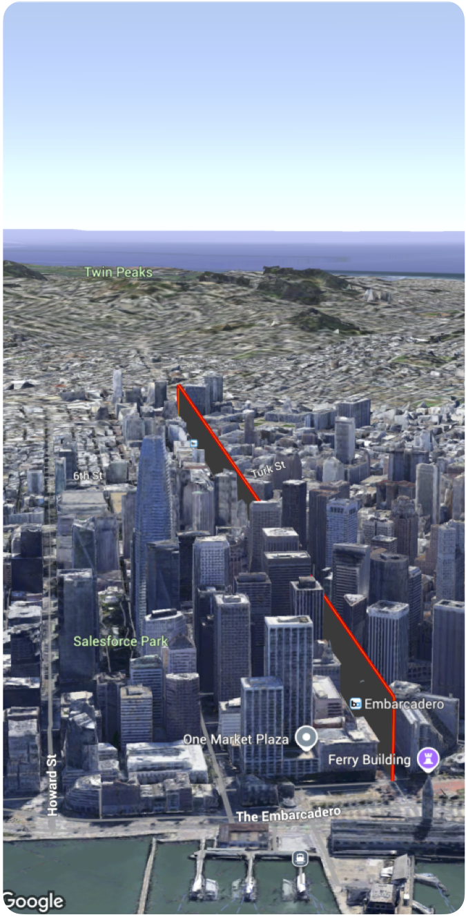
Aşağıdaki kod örneğinde, çoklu çizgi eklemek ve 3D alanda konumlandırmak için Polyline
yapısının nasıl kullanılacağı gösterilmektedir.
Swift
Polyline(coordinates: [
.init(latitude: 37.7749, longitude: -122.4194, altitude: 100),
.init(latitude: 37.7750, longitude: -122.4193, altitude: 100),
.init(latitude: 37.7751, longitude: -122.4192, altitude: 100)
]
.stroke(.init(strokeColor: .red, strokeWidth: 5.0, outerColor: .blue, outerWidth: 0.2))
.contour(.init(isGeodesic: false, extruded: true, drawOccludedSegments: true)))
Aksi belirtilmediği sürece bu sayfanın içeriği Creative Commons Atıf 4.0 Lisansı altında ve kod örnekleri Apache 2.0 Lisansı altında lisanslanmıştır. Ayrıntılı bilgi için Google Developers Site Politikaları'na göz atın. Java, Oracle ve/veya satış ortaklarının tescilli ticari markasıdır.
Son güncelleme tarihi: 2025-08-31 UTC.
[null,null,["Son güncelleme tarihi: 2025-08-31 UTC."],[],[],null,["# Add a polyline to a map\n\nSelect platform: [Android](/maps/documentation/maps-3d/android-sdk/add-polylines \"View this page for the Android platform docs.\") [iOS](/maps/documentation/maps-3d/ios-sdk/add-polylines \"View this page for the iOS platform docs.\") [JavaScript](/maps/documentation/javascript/3d/shapes-lines \"View this page for the JavaScript platform docs.\")\n\n\u003cbr /\u003e\n\n| This product or feature is Experimental (pre-GA). Pre-GA products and features might have limited support, and changes to pre-GA products and features might not be compatible with other pre-GA versions. Pre-GA Offerings are covered by the [Google\n| Maps Platform Service Specific Terms](https://cloud.google.com/maps-platform/terms/maps-service-terms). For more information, see the [launch stage descriptions](/maps/launch-stages).\n\n\nYou can add a polyline to a 3D map.\n\n\nThe following code sample demonstrates how to use the [`Polyline`](/maps/documentation/maps-3d/ios-sdk/reference/Structs/Polyline) struct to add a polyline and position it in 3D space. \n\n### Swift\n\n```swift\n Polyline(coordinates: [\n .init(latitude: 37.7749, longitude: -122.4194, altitude: 100),\n .init(latitude: 37.7750, longitude: -122.4193, altitude: 100),\n .init(latitude: 37.7751, longitude: -122.4192, altitude: 100)\n ]\n .stroke(.init(strokeColor: .red, strokeWidth: 5.0, outerColor: .blue, outerWidth: 0.2))\n .contour(.init(isGeodesic: false, extruded: true, drawOccludedSegments: true)))\n \n \n```"]]