İşaretçinin yüksekliğini yapılandırma
Koleksiyonlar ile düzeninizi koruyun
İçeriği tercihlerinize göre kaydedin ve kategorilere ayırın.
Platform seçin:
Android
iOS
3D haritaya eklediğiniz işaretçilerin yüksekliğini özelleştirebilirsiniz.
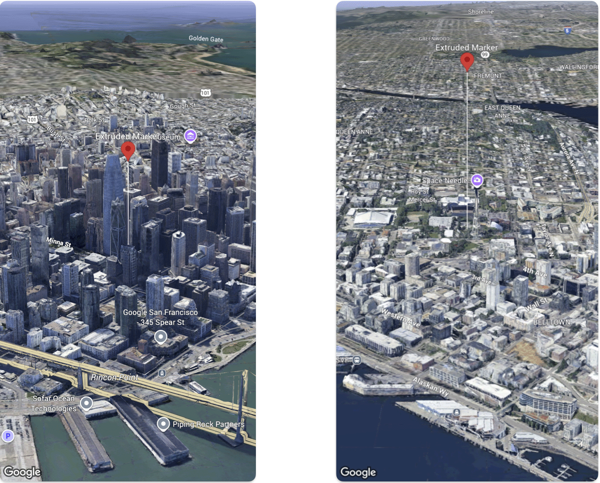
Aşağıdaki kod örneğinde, bir işaretçinin yüksekliğini ve yükseklik modunu yapılandırarak işaretçiyi ekstrüde etmek ve yüksekliğini ayarlamak için Marker
yapısının nasıl kullanılacağı gösterilmektedir.
Swift
@State var extrudedMarker: Marker = .init(
position: .init(
latitude: 37.78980534,
longitude: -122.3969349,
altitude: 50.0),
altitudeMode: .relativeToGround,
collisionBehavior: .required,
extruded: true,
drawsWhenOccluded: true,
sizePreserved: true,
zIndex: 0,
label: "Extruded marker"
)
Aksi belirtilmediği sürece bu sayfanın içeriği Creative Commons Atıf 4.0 Lisansı altında ve kod örnekleri Apache 2.0 Lisansı altında lisanslanmıştır. Ayrıntılı bilgi için Google Developers Site Politikaları'na göz atın. Java, Oracle ve/veya satış ortaklarının tescilli ticari markasıdır.
Son güncelleme tarihi: 2025-08-31 UTC.
[null,null,["Son güncelleme tarihi: 2025-08-31 UTC."],[],[],null,["# Configure marker altitude\n\nSelect platform: [Android](/maps/documentation/maps-3d/android-sdk/configure-marker-altitude \"View this page for the Android platform docs.\") [iOS](/maps/documentation/maps-3d/ios-sdk/configure-marker-altitude \"View this page for the iOS platform docs.\")\n\n\u003cbr /\u003e\n\n| This product or feature is Experimental (pre-GA). Pre-GA products and features might have limited support, and changes to pre-GA products and features might not be compatible with other pre-GA versions. Pre-GA Offerings are covered by the [Google\n| Maps Platform Service Specific Terms](https://cloud.google.com/maps-platform/terms/maps-service-terms). For more information, see the [launch stage descriptions](/maps/launch-stages).\n\n\nYou can customize the altitude of markers that you add to a 3D map.\n\n\nThe following code sample demonstrates how use the [`Marker` struct](/maps/documentation/maps-3d/ios-sdk/reference/Structs/Marker) configure the altitude and altitude mode of a marker to extrude it and set its altitude. \n\n### Swift\n\n```swift\n@State var extrudedMarker: Marker = .init(\n position: .init(\n latitude: 37.78980534,\n longitude: -122.3969349,\n altitude: 50.0),\n altitudeMode: .relativeToGround,\n collisionBehavior: .required,\n extruded: true,\n drawsWhenOccluded: true,\n sizePreserved: true,\n zIndex: 0,\n label: \"Extruded marker\"\n)\n\n \n```"]]