סקירה כללית של אריחים פוטוריאליסטיים בתלת-ממד
קל לארגן דפים בעזרת אוספים
אפשר לשמור ולסווג תוכן על סמך ההעדפות שלך.
מפתחים באזור הכלכלי האירופי (EEA)
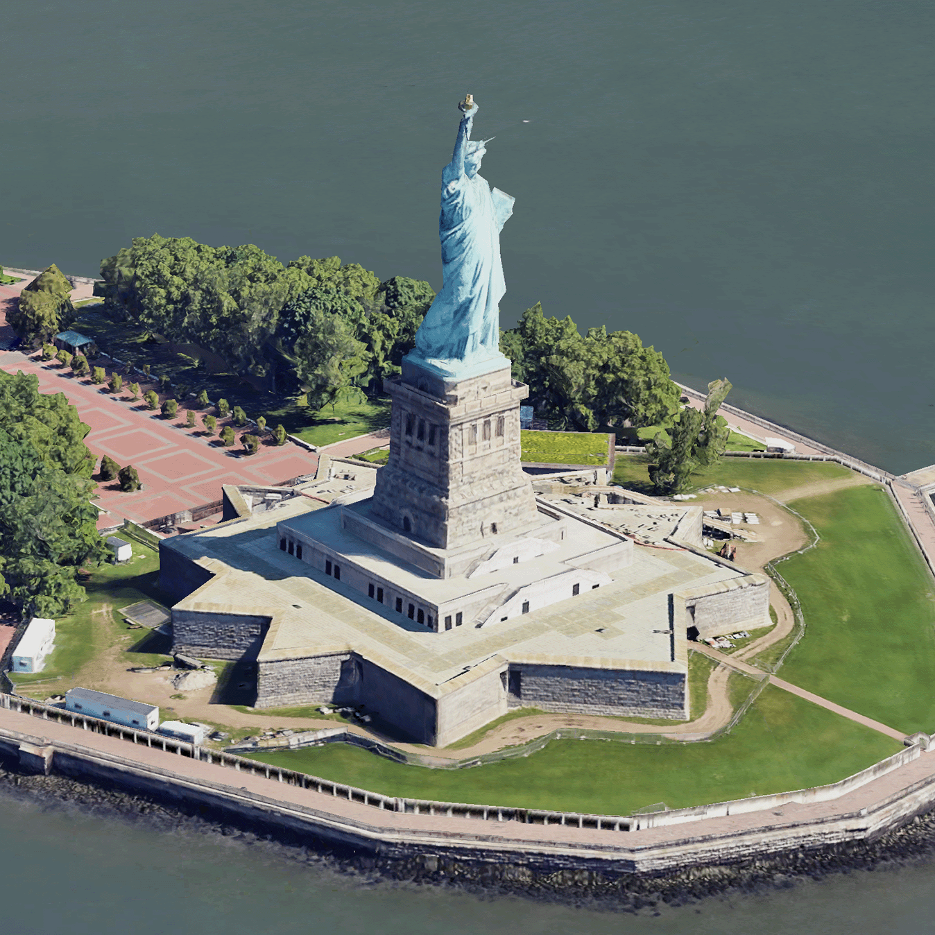
קטעי מפה ריאליסטיים בתלת-ממד הם קטעי מפה שמכילים נתונים גיאוגרפיים בתלת-ממד של Google בפורמט OGC 3D Tiles.
אתם יכולים לעבד את המפות התלת-ממדיות של Google באמצעות מעבד משלכם של 3D Tiles, או להשתמש בספריית קוד פתוח להדמיה תלת-ממדית של נתונים גיאוגרפיים.
למה כדאי להשתמש במשבצות תלת-ממדיות?
Google מציעה 3D Tiles לתרחישי שימוש של הדמיה מהדור הבא. אפשר להשתמש ב-3D Tiles כדי ליצור תצוגות פרספקטיבה מדהימות בתלת ממד, בדיוק כמו ב-Google Earth. התצוגות האלה עוזרות למשתמשים להבין טוב יותר את ההקשר הגיאוגרפי, לשפר את הניווט שלהם ולספר סיפור על מקום מסוים. באמצעות רכיב עיבוד לבחירתכם, תוכלו גם להזיז את המצלמה בצורה חלקה בסצנה כדי לראות אותה מזוויות שונות.
אזורי הכיסוי
בודקים את הכיסוי של Map Tiles API. Google מעדכנת ומוסיפה תמונות באופן קבוע.
פתרונות תלת-ממד
במרכז הארכיטקטורה של Google Maps Platform יש דוגמאות לפתרונות תלת-ממד שאפשר לבדוק כדי להתחיל להשתמש באפליקציה:
תלת-ממד של אזורים:
מאפשר לכם לחקור שכונות ואזורים באופן וירטואלי בתלת-ממד, עם
רמת פירוט גבוהה.
סיפורים בתלת-ממד:
משלבים בין סיפורים למיפוי, ומאפשרים ליוצרים ליצור סיפורים אינטראקטיביים וסוחפים באמצעות קטעי מפה ריאליסטיים בתלת-ממד.
אלא אם צוין אחרת, התוכן של דף זה הוא ברישיון Creative Commons Attribution 4.0 ודוגמאות הקוד הן ברישיון Apache 2.0. לפרטים, ניתן לעיין במדיניות האתר Google Developers. Java הוא סימן מסחרי רשום של חברת Oracle ו/או של השותפים העצמאיים שלה.
עדכון אחרון: 2025-08-29 (שעון UTC).
[null,null,["עדכון אחרון: 2025-08-29 (שעון UTC)."],[[["\u003cp\u003ePhotorealistic 3D Tiles are map tiles containing Google's 3D geodata in the OGC 3D Tiles format, allowing rendering with your own or open source 3D Tiles renderers.\u003c/p\u003e\n"],["\u003cp\u003e3D Tiles empowers next-generation visualization, enabling stunning 3D perspective views for enhanced geographic context, navigation, and storytelling.\u003c/p\u003e\n"],["\u003cp\u003eGoogle's 3D Tiles offer coverage detailed in the Map Tiles API documentation, with regular updates and imagery additions.\u003c/p\u003e\n"],["\u003cp\u003eExplore 3D solutions like the 3D Area Explorer for detailed virtual exploration and 3D Storytelling for immersive narratives using Photorealistic 3D Tiles on the Google Maps Platform Architecture Center.\u003c/p\u003e\n"]]],[],null,["# Photorealistic 3D Tiles overview\n\n**European Economic Area (EEA) developers** If your billing address is in the European Economic Area, effective on 8 July 2025, the [Google\n| Maps Platform EEA Terms of Service](https://cloud.google.com/terms/maps-platform/eea) will apply to your use of the Services. [Learn more](/maps/comms/eea/faq). In addition, certain content from the Map Tiles API will no longer be returned. [Learn more](/maps/comms/eea/map-tiles).\n\n:statue_of_liberty:Photorealistic 3D Tiles are map tiles that contain Google's 3D\ngeodata in the\n[OGC 3D Tiles format](https://www.ogc.org/standards/3DTiles).\nYou can render Google's 3D maps with your own 3D Tiles renderer, or you can use\nan open source library for 3D geospatial visualization.\n\nWhy use 3D Tiles?\n-----------------\n\nGoogle offers 3D Tiles for next-generation visualization use cases. You can use\n3D Tiles to build stunning 3D perspective views, just as you can with Google\nEarth. These views help your users better understand geographic context, improve\nhow they navigate, and they can showcase a place for storytelling. Using a\nrenderer of your choice, you can also smoothly maneuver your camera through a\nscene to view it from different angles.\n\nCoverage areas\n--------------\n\nReview the Map Tiles API's\n[coverage](/maps/coverage#countryregion-coverage). Google regularly updates and\nadds imagery.\n\n3D solutions\n------------\n\nThe [Google Maps Platform Architecture Center](/maps/architecture)\ncontains examples of 3D solutions that you can examine to get started with your\napp:\n\n- [3D Area Explorer](/maps/architecture/3d-area-explorer):\n Lets you explore neighborhoods and areas virtually and in 3D with a\n high degree of visual detail.\n\n- [3D Storytelling](/maps/architecture/3d-storytelling):\n Bridges storytelling and mapping, enabling creators to craft immersive and\n interactive narratives using Photorealistic 3D Tiles."]]