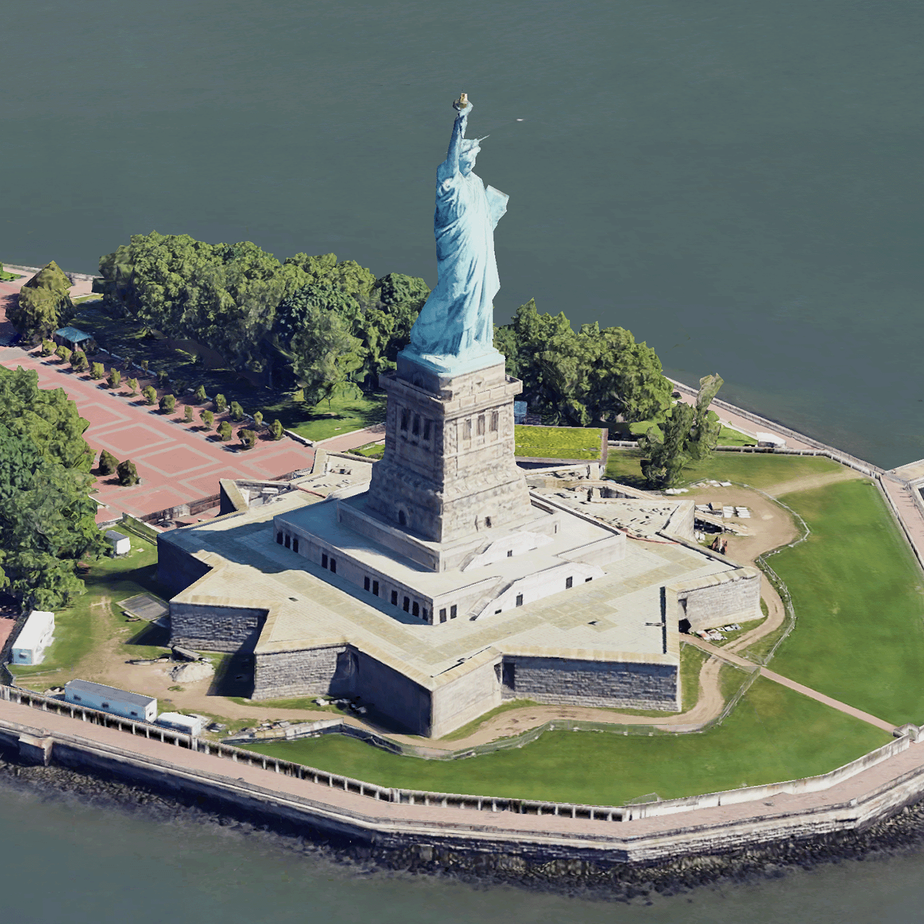
نمای کلی کاشی های سه بعدی واقعی
با مجموعهها، منظم بمانید
ذخیره و طبقهبندی محتوا براساس اولویتهای شما.
توسعه دهندگان منطقه اقتصادی اروپا (EEA).
کاشیهای سهبعدی فوتورئالیستی، کاشیهای نقشهای هستند که حاوی دادههای جغرافیایی سهبعدی Google در قالب OGC 3D Tiles هستند. میتوانید نقشههای سهبعدی Google را با رندر کاشیهای سهبعدی خود رندر کنید، یا میتوانید از یک کتابخانه منبع باز برای تجسم فضایی سهبعدی استفاده کنید.
چرا از کاشی های سه بعدی استفاده کنیم؟
Google کاشی های سه بعدی را برای موارد استفاده از تجسم نسل بعدی ارائه می دهد. میتوانید از کاشیهای سهبعدی برای ایجاد نماهای چشمانداز سهبعدی خیرهکننده، درست همانطور که با Google Earth میتوانید استفاده کنید. این نماها به کاربران شما کمک می کند تا زمینه جغرافیایی را بهتر درک کنند، نحوه پیمایش را بهبود بخشند، و می توانند مکانی را برای داستان سرایی به نمایش بگذارند. با استفاده از یک رندر دلخواه، میتوانید دوربین خود را به آرامی در یک صحنه مانور دهید تا آن را از زوایای مختلف مشاهده کنید.
مناطق تحت پوشش
پوشش Map Tiles API را مرور کنید. گوگل به طور مرتب تصاویر را به روز می کند و اضافه می کند.
راه حل های سه بعدی
مرکز معماری پلتفرم Google Maps شامل نمونههایی از راهحلهای سهبعدی است که میتوانید برای شروع با برنامه خود بررسی کنید:
3D Area Explorer : به شما امکان می دهد محله ها و مناطق را به صورت مجازی و سه بعدی با درجه بالایی از جزئیات بصری کاوش کنید.
داستانسرایی سه بعدی : داستانگویی و نقشهبرداری را پل میکند، و سازندگان را قادر میسازد تا با استفاده از کاشیهای سهبعدی فوتورئالیستی، روایتهای همهجانبه و تعاملی بسازند.
جز در مواردی که غیر از این ذکر شده باشد،محتوای این صفحه تحت مجوز Creative Commons Attribution 4.0 License است. نمونه کدها نیز دارای مجوز Apache 2.0 License است. برای اطلاع از جزئیات، به خطمشیهای سایت Google Developers مراجعه کنید. جاوا علامت تجاری ثبتشده Oracle و/یا شرکتهای وابسته به آن است.
تاریخ آخرین بهروزرسانی 2025-08-29 بهوقت ساعت هماهنگ جهانی.
[null,null,["تاریخ آخرین بهروزرسانی 2025-08-29 بهوقت ساعت هماهنگ جهانی."],[[["\u003cp\u003ePhotorealistic 3D Tiles are map tiles containing Google's 3D geodata in the OGC 3D Tiles format, allowing rendering with your own or open source 3D Tiles renderers.\u003c/p\u003e\n"],["\u003cp\u003e3D Tiles empowers next-generation visualization, enabling stunning 3D perspective views for enhanced geographic context, navigation, and storytelling.\u003c/p\u003e\n"],["\u003cp\u003eGoogle's 3D Tiles offer coverage detailed in the Map Tiles API documentation, with regular updates and imagery additions.\u003c/p\u003e\n"],["\u003cp\u003eExplore 3D solutions like the 3D Area Explorer for detailed virtual exploration and 3D Storytelling for immersive narratives using Photorealistic 3D Tiles on the Google Maps Platform Architecture Center.\u003c/p\u003e\n"]]],[],null,["# Photorealistic 3D Tiles overview\n\n**European Economic Area (EEA) developers** If your billing address is in the European Economic Area, effective on 8 July 2025, the [Google\n| Maps Platform EEA Terms of Service](https://cloud.google.com/terms/maps-platform/eea) will apply to your use of the Services. [Learn more](/maps/comms/eea/faq). In addition, certain content from the Map Tiles API will no longer be returned. [Learn more](/maps/comms/eea/map-tiles).\n\n:statue_of_liberty:Photorealistic 3D Tiles are map tiles that contain Google's 3D\ngeodata in the\n[OGC 3D Tiles format](https://www.ogc.org/standards/3DTiles).\nYou can render Google's 3D maps with your own 3D Tiles renderer, or you can use\nan open source library for 3D geospatial visualization.\n\nWhy use 3D Tiles?\n-----------------\n\nGoogle offers 3D Tiles for next-generation visualization use cases. You can use\n3D Tiles to build stunning 3D perspective views, just as you can with Google\nEarth. These views help your users better understand geographic context, improve\nhow they navigate, and they can showcase a place for storytelling. Using a\nrenderer of your choice, you can also smoothly maneuver your camera through a\nscene to view it from different angles.\n\nCoverage areas\n--------------\n\nReview the Map Tiles API's\n[coverage](/maps/coverage#countryregion-coverage). Google regularly updates and\nadds imagery.\n\n3D solutions\n------------\n\nThe [Google Maps Platform Architecture Center](/maps/architecture)\ncontains examples of 3D solutions that you can examine to get started with your\napp:\n\n- [3D Area Explorer](/maps/architecture/3d-area-explorer):\n Lets you explore neighborhoods and areas virtually and in 3D with a\n high degree of visual detail.\n\n- [3D Storytelling](/maps/architecture/3d-storytelling):\n Bridges storytelling and mapping, enabling creators to craft immersive and\n interactive narratives using Photorealistic 3D Tiles."]]