Fotogerçekçi 3D Kartlara genel bakış
Koleksiyonlar ile düzeninizi koruyun
İçeriği tercihlerinize göre kaydedin ve kategorilere ayırın.
Avrupa Ekonomik Alanı (AEA) geliştiricileri
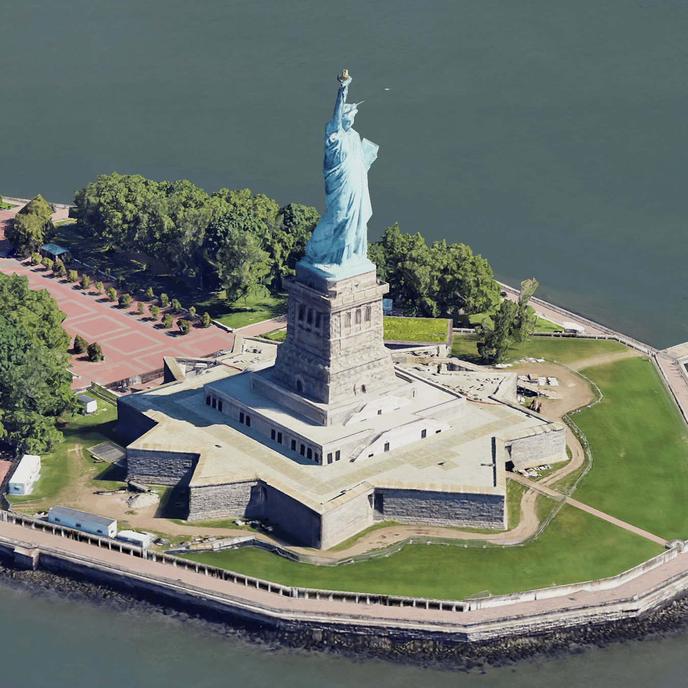
Gerçekçi Fotoğraf 3B Parçalar, OGC 3D Tiles biçiminde Google'ın 3B coğrafi verilerini içeren harita parçalarıdır.
Google'ın 3D haritalarını kendi 3D Tiles oluşturucunuzla oluşturabilir veya 3D coğrafi görselleştirme için açık kaynaklı bir kitaplık kullanabilirsiniz.
3D Tiles'ı neden kullanmalısınız?
Google, yeni nesil görselleştirme kullanım alanları için 3D Tiles sunar. Google Earth'te olduğu gibi, 3D Döşemeler'i kullanarak çarpıcı 3D perspektif görünümleri oluşturabilirsiniz. Bu görünümler, kullanıcılarınızın coğrafi bağlamı daha iyi anlamasına, gezinme şekillerini iyileştirmesine ve hikaye anlatımı için bir yer göstermesine yardımcı olur. Seçtiğiniz bir oluşturucuyla kameranızı bir sahnede sorunsuz bir şekilde hareket ettirerek farklı açılardan da görüntüleyebilirsiniz.
Kapsama alanları
Map Tiles API'nin kapsamını inceleyin. Google, görüntüleri düzenli olarak günceller ve ekler.
3D çözümleri
Google Haritalar Platformu Mimari Merkezi'nde
uygulamanızla çalışmaya başlamak için inceleyebileceğiniz 3D çözümlerin örnekleri yer alır:
3D Alan Keşfi:
Mahalleleri ve bölgeleri sanal olarak ve 3D olarak yüksek düzeyde görsel ayrıntıyla keşfetmenizi sağlar.
3D Hikaye Anlatımı:
Hikaye anlatımı ile harita oluşturmayı birleştirerek içerik üreticilerin gerçekçi fotoğraf 3B parçaları kullanarak etkileyici ve etkileşimli anlatılar oluşturmasına olanak tanır.
Aksi belirtilmediği sürece bu sayfanın içeriği Creative Commons Atıf 4.0 Lisansı altında ve kod örnekleri Apache 2.0 Lisansı altında lisanslanmıştır. Ayrıntılı bilgi için Google Developers Site Politikaları'na göz atın. Java, Oracle ve/veya satış ortaklarının tescilli ticari markasıdır.
Son güncelleme tarihi: 2025-08-29 UTC.
[null,null,["Son güncelleme tarihi: 2025-08-29 UTC."],[[["\u003cp\u003ePhotorealistic 3D Tiles are map tiles containing Google's 3D geodata in the OGC 3D Tiles format, allowing rendering with your own or open source 3D Tiles renderers.\u003c/p\u003e\n"],["\u003cp\u003e3D Tiles empowers next-generation visualization, enabling stunning 3D perspective views for enhanced geographic context, navigation, and storytelling.\u003c/p\u003e\n"],["\u003cp\u003eGoogle's 3D Tiles offer coverage detailed in the Map Tiles API documentation, with regular updates and imagery additions.\u003c/p\u003e\n"],["\u003cp\u003eExplore 3D solutions like the 3D Area Explorer for detailed virtual exploration and 3D Storytelling for immersive narratives using Photorealistic 3D Tiles on the Google Maps Platform Architecture Center.\u003c/p\u003e\n"]]],[],null,["# Photorealistic 3D Tiles overview\n\n**European Economic Area (EEA) developers** If your billing address is in the European Economic Area, effective on 8 July 2025, the [Google\n| Maps Platform EEA Terms of Service](https://cloud.google.com/terms/maps-platform/eea) will apply to your use of the Services. [Learn more](/maps/comms/eea/faq). In addition, certain content from the Map Tiles API will no longer be returned. [Learn more](/maps/comms/eea/map-tiles).\n\n:statue_of_liberty:Photorealistic 3D Tiles are map tiles that contain Google's 3D\ngeodata in the\n[OGC 3D Tiles format](https://www.ogc.org/standards/3DTiles).\nYou can render Google's 3D maps with your own 3D Tiles renderer, or you can use\nan open source library for 3D geospatial visualization.\n\nWhy use 3D Tiles?\n-----------------\n\nGoogle offers 3D Tiles for next-generation visualization use cases. You can use\n3D Tiles to build stunning 3D perspective views, just as you can with Google\nEarth. These views help your users better understand geographic context, improve\nhow they navigate, and they can showcase a place for storytelling. Using a\nrenderer of your choice, you can also smoothly maneuver your camera through a\nscene to view it from different angles.\n\nCoverage areas\n--------------\n\nReview the Map Tiles API's\n[coverage](/maps/coverage#countryregion-coverage). Google regularly updates and\nadds imagery.\n\n3D solutions\n------------\n\nThe [Google Maps Platform Architecture Center](/maps/architecture)\ncontains examples of 3D solutions that you can examine to get started with your\napp:\n\n- [3D Area Explorer](/maps/architecture/3d-area-explorer):\n Lets you explore neighborhoods and areas virtually and in 3D with a\n high degree of visual detail.\n\n- [3D Storytelling](/maps/architecture/3d-storytelling):\n Bridges storytelling and mapping, enabling creators to craft immersive and\n interactive narratives using Photorealistic 3D Tiles."]]