Dibuja polilíneas en un mapa
Organiza tus páginas con colecciones
Guarda y categoriza el contenido según tus preferencias.

En este ejemplo, se muestra un mapa del Océano Atlántico Norte con la ruta del Titanic dibujada en él.
Comenzar
Antes de probar el código de muestra, debes configurar tu entorno de desarrollo.
Para obtener más información, consulta Cómo configurar un proyecto de Flutter.
Consulta el código
Dart
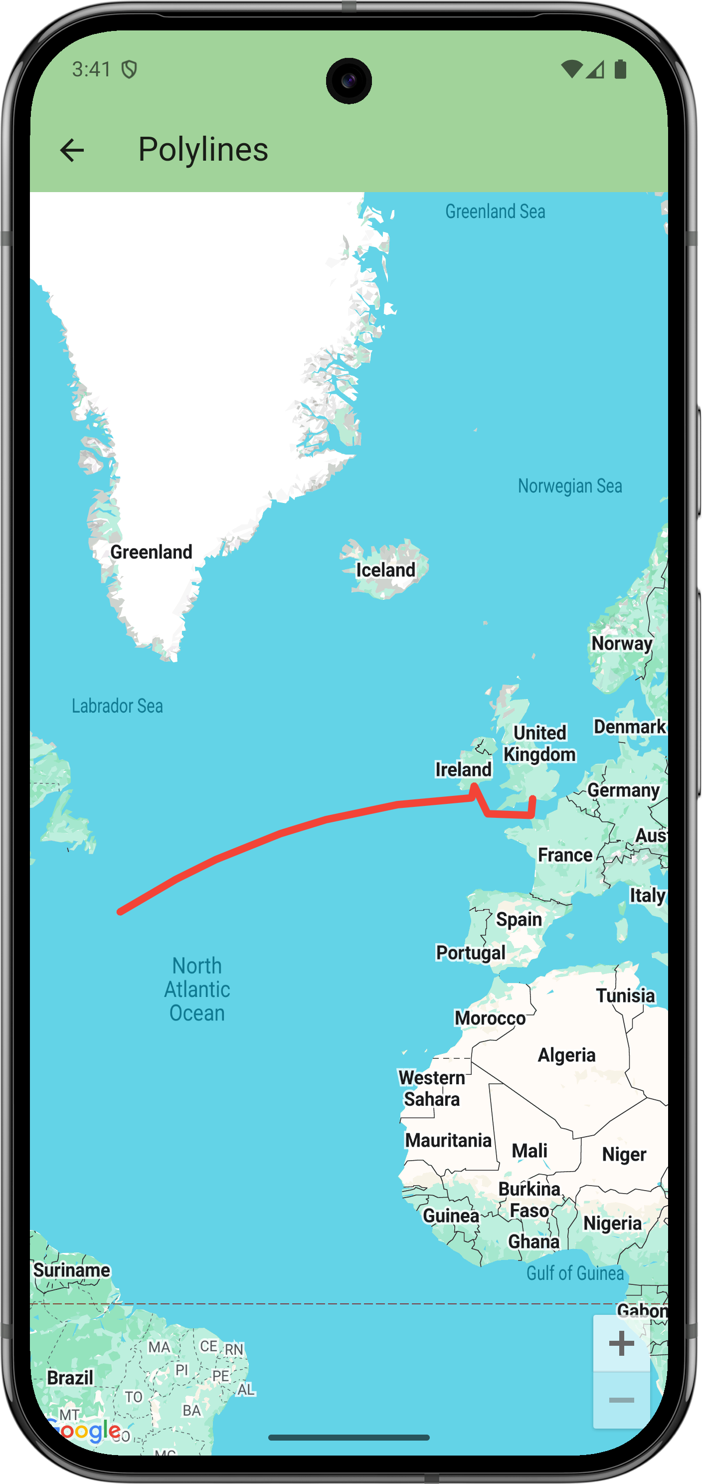
// Copyright 2025 Google LLC
//
// Licensed under the Apache License, Version 2.0 (the "License");
// you may not use this file except in compliance with the License.
// You may obtain a copy of the License at
//
// https://www.apache.org/licenses/LICENSE-2.0
//
// Unless required by applicable law or agreed to in writing, software
// distributed under the License is distributed on an "AS IS" BASIS,
// WITHOUT WARRANTIES OR CONDITIONS OF ANY KIND, either express or implied.
// See the License for the specific language governing permissions and
// limitations under the License.
import 'package:flutter/material.dart';
import 'package:google_maps_flutter/google_maps_flutter.dart';
/// Displays a map of the North Atlantic Ocean with the route of the Titanic
/// marked on it.
class PolylinesSample extends StatelessWidget {
const PolylinesSample({super.key});
@override
Widget build(BuildContext context) {
return GoogleMap(
initialCameraPosition: CameraPosition(target: LatLng(49, -23)),
polylines: {
Polyline(
// Polyline id must be unique.
polylineId: PolylineId('titanic route'),
points: [
LatLng(50.90, -1.41), // Southampton
LatLng(49.65, -1.60), // Cherbourg
LatLng(49.77, -6.71),
LatLng(51.83, -8.28), // Cobh
LatLng(50.96, -8.58),
LatLng(41.75, -49.90), // Wreck
],
width: 5,
color: Colors.red,
geodesic: true,
// Custom caps and joint types aren't supported on all platforms.
startCap: Cap.roundCap,
endCap: Cap.roundCap,
jointType: JointType.round,
consumeTapEvents: true,
onTap: () => debugPrint('clicked route'),
),
},
);
}
}
Próximos pasos
Consulta el conjunto completo de muestras en GitHub:
Ver en GitHub
Como alternativa, clona el conjunto completo de muestras para ejecutarlas de forma local. Para ello, ejecuta los siguientes comandos:
git clone -b flutter_samples https://github.com/googlemaps-samples/flutter-maps-samples.git
cd flutter-samples
flutter pub get
Salvo que se indique lo contrario, el contenido de esta página está sujeto a la licencia Atribución 4.0 de Creative Commons, y los ejemplos de código están sujetos a la licencia Apache 2.0. Para obtener más información, consulta las políticas del sitio de Google Developers. Java es una marca registrada de Oracle o sus afiliados.
Última actualización: 2025-09-03 (UTC)
[null,null,["Última actualización: 2025-09-03 (UTC)"],[],[],null,["# Draw polylines on a map\n\nThis example displays a map of the North Atlantic Ocean with the route of the Titanic drawn on it.\n\nGet started\n-----------\n\nBefore you can try the sample code, you must configure your development environment.\nFor more information, see [Set up a Flutter project](/maps/flutter-package/config).\n\nView the code\n-------------\n\n### Dart\n\n```python\n// Copyright 2025 Google LLC\n//\n// Licensed under the Apache License, Version 2.0 (the \"License\");\n// you may not use this file except in compliance with the License.\n// You may obtain a copy of the License at\n//\n// https://www.apache.org/licenses/LICENSE-2.0\n//\n// Unless required by applicable law or agreed to in writing, software\n// distributed under the License is distributed on an \"AS IS\" BASIS,\n// WITHOUT WARRANTIES OR CONDITIONS OF ANY KIND, either express or implied.\n// See the License for the specific language governing permissions and\n// limitations under the License.\n\nimport 'package:flutter/material.dart';\nimport 'package:google_maps_flutter/google_maps_flutter.dart';\n\n/// Displays a map of the North Atlantic Ocean with the route of the Titanic\n/// marked on it.\nclass PolylinesSample extends StatelessWidget {\n const PolylinesSample({super.key});\n\n @override\n Widget build(BuildContext context) {\n return GoogleMap(\n initialCameraPosition: CameraPosition(target: LatLng(49, -23)),\n polylines: {\n Polyline(\n // Polyline id must be unique.\n polylineId: PolylineId('titanic route'),\n points: [\n LatLng(50.90, -1.41), // Southampton\n LatLng(49.65, -1.60), // Cherbourg\n LatLng(49.77, -6.71),\n LatLng(51.83, -8.28), // Cobh\n LatLng(50.96, -8.58),\n LatLng(41.75, -49.90), // Wreck\n ],\n width: 5,\n color: Colors.red,\n geodesic: true,\n // Custom caps and joint types aren't supported on all platforms.\n startCap: Cap.roundCap,\n endCap: Cap.roundCap,\n jointType: JointType.round,\n consumeTapEvents: true,\n onTap: () =\u003e debugPrint('clicked route'),\n ),\n },\n );\n }\n}\nhttps://github.com/googlemaps-samples/flutter-maps-samples/blob/8f227e8b4d07179e5fb7cc5e8d8cb5440befd229/lib/samples/polylines.dart\n \n```\n\nNext steps\n----------\n\nView the complete set of samples on GitHub:\n\n[View on GitHub](https://github.com/googlemaps-samples/flutter-maps-samples/tree/main/lib/samples)\n\nAlternatively, clone the full set of samples to run them locally by executing the following commands: \n\n git clone -b flutter_samples https://github.com/googlemaps-samples/flutter-maps-samples.git\n cd flutter-samples\n flutter pub get"]]