چند خطوط را روی نقشه بکشید
با مجموعهها، منظم بمانید
ذخیره و طبقهبندی محتوا براساس اولویتهای شما.

این مثال نقشه ای از اقیانوس اطلس شمالی را نشان می دهد که مسیر کشتی تایتانیک روی آن ترسیم شده است.
شروع کنید
قبل از اینکه بتوانید کد نمونه را امتحان کنید، باید محیط توسعه خود را پیکربندی کنید. برای اطلاعات بیشتر، راه اندازی یک پروژه فلاتر را ببینید.
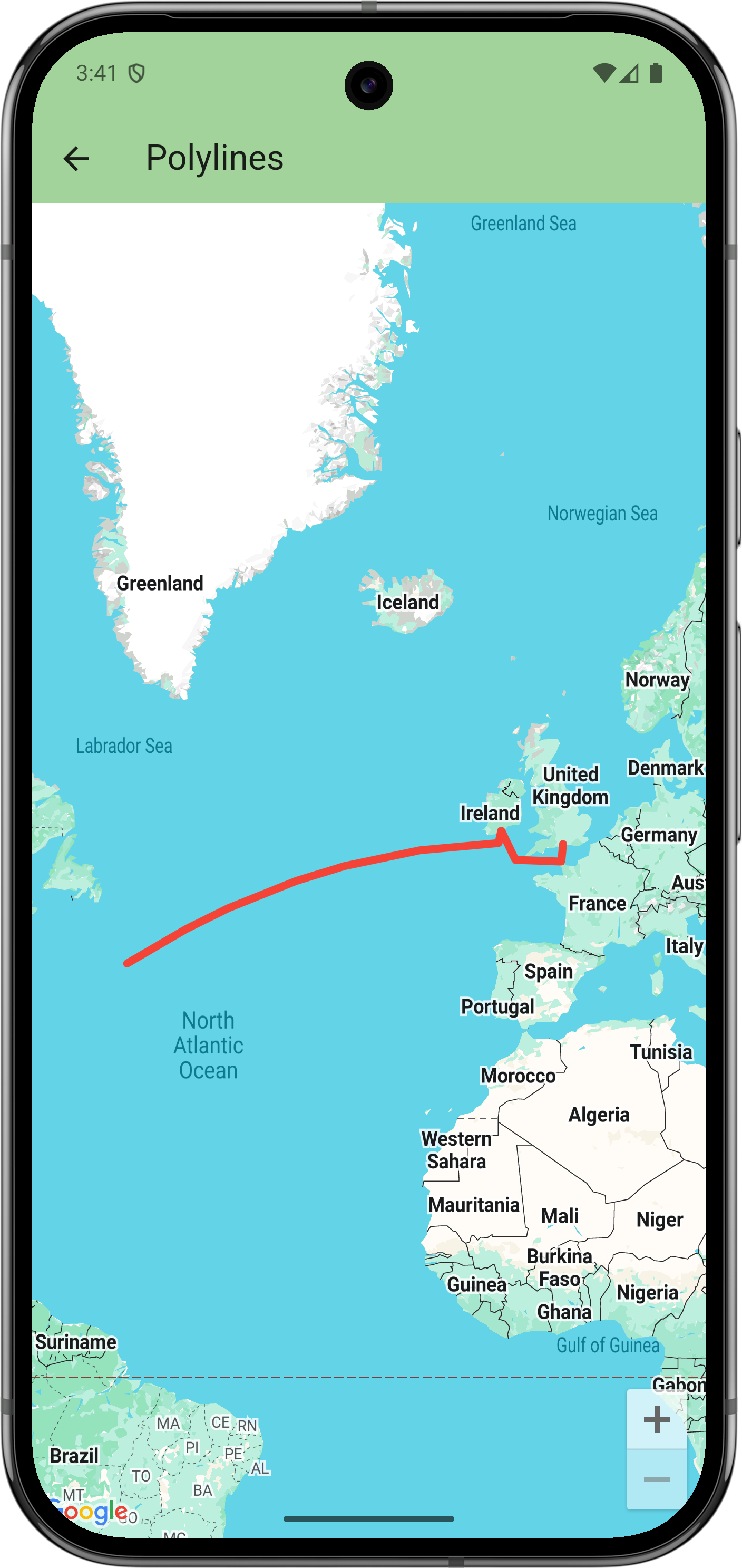
کد را مشاهده کنید
دارت
// Copyright 2025 Google LLC
//
// Licensed under the Apache License, Version 2.0 (the "License");
// you may not use this file except in compliance with the License.
// You may obtain a copy of the License at
//
// https://www.apache.org/licenses/LICENSE-2.0
//
// Unless required by applicable law or agreed to in writing, software
// distributed under the License is distributed on an "AS IS" BASIS,
// WITHOUT WARRANTIES OR CONDITIONS OF ANY KIND, either express or implied.
// See the License for the specific language governing permissions and
// limitations under the License.
import 'package:flutter/material.dart';
import 'package:google_maps_flutter/google_maps_flutter.dart';
/// Displays a map of the North Atlantic Ocean with the route of the Titanic
/// marked on it.
class PolylinesSample extends StatelessWidget {
const PolylinesSample({super.key});
@override
Widget build(BuildContext context) {
return GoogleMap(
initialCameraPosition: CameraPosition(target: LatLng(49, -23)),
polylines: {
Polyline(
// Polyline id must be unique.
polylineId: PolylineId('titanic route'),
points: [
LatLng(50.90, -1.41), // Southampton
LatLng(49.65, -1.60), // Cherbourg
LatLng(49.77, -6.71),
LatLng(51.83, -8.28), // Cobh
LatLng(50.96, -8.58),
LatLng(41.75, -49.90), // Wreck
],
width: 5,
color: Colors.red,
geodesic: true,
// Custom caps and joint types aren't supported on all platforms.
startCap: Cap.roundCap,
endCap: Cap.roundCap,
jointType: JointType.round,
consumeTapEvents: true,
onTap: () => debugPrint('clicked route'),
),
},
);
}
}
مراحل بعدی
مجموعه کامل نمونه ها را در GitHub مشاهده کنید:
در GitHub مشاهده کنید
همچنین، با اجرای دستورات زیر، مجموعه کامل نمونهها را برای اجرای محلی آنها کلون کنید:
git clone -b flutter_samples https://github.com/googlemaps-samples/flutter-maps-samples.git
cd flutter-samples
flutter pub get
جز در مواردی که غیر از این ذکر شده باشد،محتوای این صفحه تحت مجوز Creative Commons Attribution 4.0 License است. نمونه کدها نیز دارای مجوز Apache 2.0 License است. برای اطلاع از جزئیات، به خطمشیهای سایت Google Developers مراجعه کنید. جاوا علامت تجاری ثبتشده Oracle و/یا شرکتهای وابسته به آن است.
تاریخ آخرین بهروزرسانی 2025-09-03 بهوقت ساعت هماهنگ جهانی.
[null,null,["تاریخ آخرین بهروزرسانی 2025-09-03 بهوقت ساعت هماهنگ جهانی."],[],[],null,["# Draw polylines on a map\n\nThis example displays a map of the North Atlantic Ocean with the route of the Titanic drawn on it.\n\nGet started\n-----------\n\nBefore you can try the sample code, you must configure your development environment.\nFor more information, see [Set up a Flutter project](/maps/flutter-package/config).\n\nView the code\n-------------\n\n### Dart\n\n```python\n// Copyright 2025 Google LLC\n//\n// Licensed under the Apache License, Version 2.0 (the \"License\");\n// you may not use this file except in compliance with the License.\n// You may obtain a copy of the License at\n//\n// https://www.apache.org/licenses/LICENSE-2.0\n//\n// Unless required by applicable law or agreed to in writing, software\n// distributed under the License is distributed on an \"AS IS\" BASIS,\n// WITHOUT WARRANTIES OR CONDITIONS OF ANY KIND, either express or implied.\n// See the License for the specific language governing permissions and\n// limitations under the License.\n\nimport 'package:flutter/material.dart';\nimport 'package:google_maps_flutter/google_maps_flutter.dart';\n\n/// Displays a map of the North Atlantic Ocean with the route of the Titanic\n/// marked on it.\nclass PolylinesSample extends StatelessWidget {\n const PolylinesSample({super.key});\n\n @override\n Widget build(BuildContext context) {\n return GoogleMap(\n initialCameraPosition: CameraPosition(target: LatLng(49, -23)),\n polylines: {\n Polyline(\n // Polyline id must be unique.\n polylineId: PolylineId('titanic route'),\n points: [\n LatLng(50.90, -1.41), // Southampton\n LatLng(49.65, -1.60), // Cherbourg\n LatLng(49.77, -6.71),\n LatLng(51.83, -8.28), // Cobh\n LatLng(50.96, -8.58),\n LatLng(41.75, -49.90), // Wreck\n ],\n width: 5,\n color: Colors.red,\n geodesic: true,\n // Custom caps and joint types aren't supported on all platforms.\n startCap: Cap.roundCap,\n endCap: Cap.roundCap,\n jointType: JointType.round,\n consumeTapEvents: true,\n onTap: () =\u003e debugPrint('clicked route'),\n ),\n },\n );\n }\n}\nhttps://github.com/googlemaps-samples/flutter-maps-samples/blob/8f227e8b4d07179e5fb7cc5e8d8cb5440befd229/lib/samples/polylines.dart\n \n```\n\nNext steps\n----------\n\nView the complete set of samples on GitHub:\n\n[View on GitHub](https://github.com/googlemaps-samples/flutter-maps-samples/tree/main/lib/samples)\n\nAlternatively, clone the full set of samples to run them locally by executing the following commands: \n\n git clone -b flutter_samples https://github.com/googlemaps-samples/flutter-maps-samples.git\n cd flutter-samples\n flutter pub get"]]