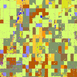
2009년부터 캐나다 농업식품부 (AAFC)의 과학기술부 (STB) 지구 관측팀은 연간 작물 유형 디지털 지도를 생성하는 과정을 시작했습니다. 2009년과 2010년에 Prairie Provinces에 초점을 맞춰 광학 (Landsat-5, AWiFS, DMC) 및 레이더 (Radarsat-2) 기반 위성 이미지를 사용하여 의사결정 트리 (DT) 기반 방법론을 적용했습니다. 2011년 재배 시즌부터 이 활동은 전국 작물 인벤토리를 지원하기 위해 다른 주로 확대되었습니다.
현재까지 이 접근 방식을 사용하면 최종 공간 해상도 30m (2009년과 2010년에는 56m)에서 전체 목표 정확도 85% 이상을 충족하는 작물 인벤토리를 일관되게 제공할 수 있습니다.
[null,null,[],[[["\u003cp\u003eThe Annual Crop Inventory (ACI) dataset provides annual crop type maps for Canada, starting from 2009 and updated yearly.\u003c/p\u003e\n"],["\u003cp\u003eThe dataset utilizes a Decision Tree methodology and satellite imagery (optical and radar) to classify cropland with an accuracy target of at least 85%.\u003c/p\u003e\n"],["\u003cp\u003eIt offers a 30-meter resolution and includes a comprehensive land cover classification with values representing various crop types, land uses, and infrastructure.\u003c/p\u003e\n"],["\u003cp\u003eThe ACI dataset is provided by Agriculture and Agri-Food Canada and is openly accessible under the OGL-Canada-2.0 license.\u003c/p\u003e\n"],["\u003cp\u003eUsers can access and analyze the dataset using Google Earth Engine for research, education, and non-profit purposes.\u003c/p\u003e\n"]]],["Agriculture and Agri-Food Canada (AAFC) initiated annual crop type mapping in 2009, utilizing optical and radar satellite imagery. The dataset, available from 2009 to 2023, employs a Decision Tree methodology to classify land cover, including specific crops. With a 30-meter pixel size and annual cadence, this inventory achieves at least 85% overall accuracy. The classification includes 255 different crops or land types, with a landcover band representing them.\n"],null,["# Canada AAFC Annual Crop Inventory\n\nDataset Availability\n: 2009-01-01T00:00:00Z--2023-01-01T00:00:00Z\n\nDataset Provider\n:\n\n\n [Agriculture and Agri-Food Canada](https://open.canada.ca/data/en/dataset/ba2645d5-4458-414d-b196-6303ac06c1c9)\n\nCadence\n: 1 Year\n\nTags\n:\n [agriculture](/earth-engine/datasets/tags/agriculture) [canada](/earth-engine/datasets/tags/canada) [crop](/earth-engine/datasets/tags/crop) [landcover](/earth-engine/datasets/tags/landcover) \naafc \n\n#### Description\n\nStarting in 2009, the Earth Observation Team of the Science and Technology\nBranch (STB) at Agriculture and Agri-Food Canada (AAFC) began the process\nof generating annual crop type digital maps. Focusing on the Prairie\nProvinces in 2009 and 2010, a Decision Tree (DT) based methodology was\napplied using optical (Landsat-5, AWiFS, DMC) and radar (Radarsat-2) based\nsatellite images. Beginning with the 2011 growing season, this activity has\nbeen extended to other provinces in support of a national crop inventory.\nTo date this approach can consistently deliver a crop inventory that meets\nthe overall target accuracy of at least 85% at a final spatial resolution of\n30m (56m in 2009 and 2010).\n\n### Bands\n\n\n**Pixel Size**\n\n30 meters\n\n**Bands**\n\n| Name | Min | Max | Pixel Size | Description |\n|-------------|-----|-----|------------|-----------------------------------------------|\n| `landcover` | 1 | 255 | meters | Main crop-specific land cover classification. |\n\n**landcover Class Table**\n\n| Value | Color | Description |\n|-------|---------|--------------------------------|\n| 10 | #000000 | Cloud |\n| 20 | #3333ff | Water |\n| 30 | #996666 | Exposed Land and Barren |\n| 34 | #cc6699 | Urban and Developed |\n| 35 | #e1e1e1 | Greenhouses |\n| 50 | #ffff00 | Shrubland |\n| 80 | #993399 | Wetland |\n| 85 | #501b50 | Peatland |\n| 110 | #cccc00 | Grassland |\n| 120 | #cc6600 | Agriculture (undifferentiated) |\n| 122 | #ffcc33 | Pasture and Forages |\n| 130 | #7899f6 | Too Wet to be Seeded |\n| 131 | #ff9900 | Fallow |\n| 132 | #660000 | Cereals |\n| 133 | #dae31d | Barley |\n| 134 | #d6cc00 | Other Grains |\n| 135 | #d2db25 | Millet |\n| 136 | #d1d52b | Oats |\n| 137 | #cace32 | Rye |\n| 138 | #c3c63a | Spelt |\n| 139 | #b9bc44 | Triticale |\n| 140 | #a7b34d | Wheat |\n| 141 | #b9c64e | Switchgrass |\n| 142 | #999900 | Sorghum |\n| 143 | #e9e2b1 | Quinoa |\n| 145 | #92a55b | Winter Wheat |\n| 146 | #809769 | Spring Wheat |\n| 147 | #ffff99 | Corn |\n| 148 | #98887c | Tobacco |\n| 149 | #799b93 | Ginseng |\n| 150 | #5ea263 | Oilseeds |\n| 151 | #52ae77 | Borage |\n| 152 | #41bf7a | Camelina |\n| 153 | #d6ff70 | Canola and Rapeseed |\n| 154 | #8c8cff | Flaxseed |\n| 155 | #d6cc00 | Mustard |\n| 156 | #ff7f00 | Safflower |\n| 157 | #315491 | Sunflower |\n| 158 | #cc9933 | Soybeans |\n| 160 | #896e43 | Pulses |\n| 161 | #996633 | Other Pulses |\n| 162 | #8f6c3d | Peas |\n| 163 | #b6a472 | Chickpeas |\n| 167 | #82654a | Beans |\n| 168 | #a39069 | Fababeans |\n| 174 | #b85900 | Lentils |\n| 175 | #b74b15 | Vegetables |\n| 176 | #ff8a8a | Tomatoes |\n| 177 | #ffcccc | Potatoes |\n| 178 | #6f55ca | Sugarbeets |\n| 179 | #ffccff | Other Vegetables |\n| 180 | #dc5424 | Fruits |\n| 181 | #d05a30 | Berries |\n| 182 | #d20000 | Blueberry |\n| 183 | #cc0000 | Cranberry |\n| 185 | #dc3200 | Other Berry |\n| 188 | #ff6666 | Orchards |\n| 189 | #c5453b | Other Fruits |\n| 190 | #7442bd | Vineyards |\n| 191 | #ffcccc | Hops |\n| 192 | #b5fb05 | Sod |\n| 193 | #ccff05 | Herbs |\n| 194 | #07f98c | Nursery |\n| 195 | #00ffcc | Buckwheat |\n| 196 | #cc33cc | Canaryseed |\n| 197 | #8e7672 | Hemp |\n| 198 | #b1954f | Vetch |\n| 199 | #749a66 | Other Crops |\n| 200 | #009900 | Forest (undifferentiated) |\n| 210 | #006600 | Coniferous |\n| 220 | #00cc00 | Broadleaf |\n| 230 | #cc9900 | Mixedwood |\n\n### Image Properties\n\n**Image Properties**\n\n| Name | Type | Description |\n|-------------------------|-------------|----------------------------------------------------------------------|\n| landcover_class_names | STRING_LIST | Array of cropland landcover classification names. |\n| landcover_class_palette | STRING_LIST | Array of hex code color strings used for the classification palette. |\n| landcover_class_values | INT_LIST | Value of the land cover classification. |\n\n### Terms of Use\n\n**Terms of Use**\n\n[OGL-Canada-2.0](https://spdx.org/licenses/OGL-Canada-2.0.html)\n\n### Citations\n\nCitations:\n\n- Agriculture and Agri-Food Canada Annual Crop Inventory. {YEAR}\n\n### Explore with Earth Engine\n\n| **Important:** Earth Engine is a platform for petabyte-scale scientific analysis and visualization of geospatial datasets, both for public benefit and for business and government users. Earth Engine is free to use for research, education, and nonprofit use. To get started, please [register for Earth Engine access.](https://console.cloud.google.com/earth-engine)\n\n### Code Editor (JavaScript)\n\n```javascript\nvar dataset = ee.ImageCollection('AAFC/ACI');\nvar crop2016 = dataset\n .filter(ee.Filter.date('2016-01-01', '2016-12-31'))\n .first();\nMap.setCenter(-103.8881, 53.0372, 10);\nMap.addLayer(crop2016, {}, '2016 Canada AAFC Annual Crop Inventory');\n```\n[Open in Code Editor](https://code.earthengine.google.com/?scriptPath=Examples:Datasets/AAFC/AAFC_ACI) \n[Canada AAFC Annual Crop Inventory](/earth-engine/datasets/catalog/AAFC_ACI) \nStarting in 2009, the Earth Observation Team of the Science and Technology Branch (STB) at Agriculture and Agri-Food Canada (AAFC) began the process of generating annual crop type digital maps. Focusing on the Prairie Provinces in 2009 and 2010, a Decision Tree (DT) based methodology was applied using optical (Landsat-5, ... \nAAFC/ACI, agriculture,canada,crop,landcover \n2009-01-01T00:00:00Z/2023-01-01T00:00:00Z \n36.83 -135.17 62.25 -51.24 \nGoogle Earth Engine \nhttps://developers.google.com/earth-engine/datasets\n\n- [](https://doi.org/https://open.canada.ca/data/en/dataset/ba2645d5-4458-414d-b196-6303ac06c1c9)\n- [](https://doi.org/https://developers.google.com/earth-engine/datasets/catalog/AAFC_ACI)"]]