- ডেটাসেটের প্রাপ্যতা
- 2012-01-01T00:00:00Z–2012-01-01T00:00:00Z
- ডেটাসেট প্রযোজক
- এএইচএন
- ট্যাগ
বর্ণনা
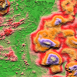
এএইচএন ডিইএম হলো নেদারল্যান্ডসকে আবৃতকারী একটি ০.৫ মিটার ডিইএম। এটি ২০০৭ থেকে ২০১২ সালের মধ্যে বসন্তকালে সংগৃহীত লাইডার ডেটা থেকে তৈরি করা হয়েছিল।
এতে ভূপৃষ্ঠের নমুনা রয়েছে এবং মাটির উপরের অন্যান্য সমস্ত বস্তু (যেমন ভবন, সেতু, গাছ ইত্যাদি) সরিয়ে ফেলা হয়েছে। এই সংস্করণটি ইন্টারপোলেটেড; যে স্থানগুলো থেকে বস্তুগুলো সরানো হয়েছে, সেগুলো ইন্টারপোলেটেড মান দিয়ে পূরণ করা হয়েছে। পয়েন্ট ক্লাউডটিকে একটি স্কয়ার্ড ইনভার্স ডিসটেন্স ওয়েটিং পদ্ধতি ব্যবহার করে ০.৫ মিটার গ্রিডে রূপান্তরিত করা হয়েছে।
ব্যান্ড
ব্যান্ড
পিক্সেল সাইজ: ০.৫ মিটার (সকল ব্যান্ড)
| নাম | ইউনিট | পিক্সেল আকার | বর্ণনা |
|---|---|---|---|
elevation | এম | ০.৫ মিটার | উচ্চতা |
ব্যবহারের শর্তাবলী
ব্যবহারের শর্তাবলী
AHN-এর ডেটাসেটগুলো ওপেন ডেটা হিসেবে উপলব্ধ। এর অর্থ হলো, যে কেউ বিনামূল্যে এবং কোনো বিধিনিষেধ ছাড়াই এই ডেটা ব্যবহার করতে পারেন। আরও তথ্যের জন্য ওপেন ডেটা পেজটি দেখুন। CC-0 লাইসেন্সের শর্তাবলীর অধীনে ডেটা ডাউনলোড করা যায়।
আর্থ ইঞ্জিন দিয়ে অন্বেষণ করুন
কোড এডিটর (জাভাস্ক্রিপ্ট)
var dataset = ee.Image('AHN/AHN2_05M_INT');
var elevation = dataset.select('elevation');
var elevationVis = {
  min: -5.0,
  max: 30.0,
};
Map.setCenter(5.76583, 51.855276, 16);
Map.addLayer(elevation, elevationVis, 'Elevation');
import ee
import geemap.core as geemap
কোলাব (পাইথন)
dataset = ee.Image('AHN/AHN2_05M_INT')
elevation = dataset.select('elevation')
elevation_vis = {'min': -5.0, 'max': 30.0}

m = geemap.Map()
m.set_center(5.76583, 51.855276, 16)
m.add_layer(elevation, elevation_vis, 'Elevation')
m