- זמינות קבוצת הנתונים
- 2019-01-01T01:00:00Z–2020-01-01T01:00:00Z
- מפיק מערך הנתונים
- National Forest Information System
- תגים
תיאור
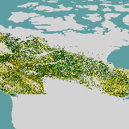
קבוצת הנתונים של יערות ראשוניים בקנדה היא מפה של גיל היערות לשנת 2019 באזורים האקולוגיים המיוערים של קנדה, ברזולוציה מרחבית של 30 מטרים. כדי לקבוע את הגיל נעשה שימוש בנתונים שמתקבלים מחישה מרחוק מ-Landsat (הפרעות, קומפוזיציות של החזרת אור מפני השטח, מבנה יער) ומ-MODIS (ייצור ראשוני ברוטו).
אפשר לקבוע את גיל היער במקומות שבהם אפשר לזהות הפרעה ישירות (גישת ההפרעה), או להסיק אותו באמצעות מידע ספקטרלי (גישת ההתאוששות) או באמצעות משוואות אלומטריות הפוכות כדי ליצור מודל של הגיל במקומות שבהם אין עדות להפרעה (גישה אלומטרית). הגישה של הפרעות מבוססת על נתוני לוויין ועל שינויים שמופו, והיא הכי מדויקת. הגישה לשחזור מסתמכת גם על נתונים מלוויין ועל לוגיקה לגבי התפתחות היער, עם רמת דיוק גבוהה יותר מאשר מודלים טהורים.
בהתחשב בכך שלא היו הפרעות נרחבות לאחרונה ביערות של קנדה, נדרש שימוש בגישה האלומטרית בשטח הגדול ביותר (86.6%). הגילאים מוערכים באמצעות מידע על הגבהים והגידולים בפועל, ועל מודלים של יבול, במקרים שבהם אין אפשרות אחרת. המיפוי כולל עצים בכל הגילאים, ועצים בני יותר מ-150 שנה משולבים בקטגוריה 'עץ ותיק'.
תחום תדרים
תחום תדרים
גודל הפיקסל: 30 מטרים (כל הפסים)
| שם | יחידות | גודל הפיקסל | תיאור |
|---|---|---|---|
forest |
y | 30 מטרים | גיל היער |
תנאים והגבלות
תנאים והגבלות
מפת גיל היער שמתוארת כאן עבור מערכות אקולוגיות מיוערות בקנדה היא קוד פתוח ונתמכת על ידי ממשלת קנדה. הרישיון של מערך הנתונים הוא CC-BY 4.0.
סיור עם פלטפורמת Earth Engine
עורך קוד (JavaScript)
var dataset = ee.ImageCollection('CANADA/NFIS/NTEMS/CA_FOREST_AGE');

Map.setCenter(-107.94, 58.18, 3);
Map.addLayer(
    dataset,
    {palette: ['006600', '002200', 'fff700', 'ab7634', 'c4d0ff', 'ffffff']},
    'Canada Primary Forest Data');