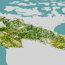
-
Canada AAFC Annual Crop Inventory
החל משנת 2009, צוות התצפית על כדור הארץ של המחלקה למדע וטכנולוגיה (STB) ב-Agriculture and Agri-Food Canada (AAFC) התחיל בתהליך יצירת מפות דיגיטליות שנתיות של סוגי גידולים. מתמקדים בפרובינציות Prairie בשנים 2009 ו-2010, מתודולוגיה המבוססת על עץ החלטות (DT) … agriculture canada crop landcover -
Canadian Digital Elevation Model
מודל הגובה הדיגיטלי של קנדה (CDEM) הוא חלק ממערכת האלטימטריה של Natural Resources Canada (NRCan), והוא נגזר מנתוני הגובה הדיגיטליים הקיימים של קנדה (CDED). בנתונים האלה, הגבהות יכולות להיות גובה הקרקע או גובה משטח רפלקטיבי. ה-CDEM מורכב מכמה מודלים של DEM עם … canada dem elevation elevation-topography geophysical topography -
גיל היער בקנדה בשנת 2019, על סמך נתוני Landsat
מערך הנתונים של יערות ראשיים בקנדה הוא מפה של גיל היערות לשנת 2019 שמבוססת על לוויין, בכל אזורי היערות של קנדה ברזולוציה מרחבית של 30 מ'. כדי לקבוע את הגיל, נעשה שימוש בנתונים מרחוק מ-Landsat (שיבושים, תרכובות של השתקפות פני השטח, מבנה היער) ומ-MODIS (ייצור ראשוני ברוטו). גיל היער יכול להיות … canada forest forest-biomass
Datasets tagged canada in Earth Engine
[null,null,[],[[["\u003cp\u003eAgriculture and Agri-Food Canada (AAFC) provides annual crop type maps focusing on the Canadian Prairie Provinces.\u003c/p\u003e\n"],["\u003cp\u003eA satellite-based forest age map for Canada is available, utilizing Landsat and MODIS data for a 30-m resolution view of forested ecozones.\u003c/p\u003e\n"],["\u003cp\u003eThe Canadian Digital Elevation Model (CDEM) offers elevation data, encompassing both ground and reflective surface measurements.\u003c/p\u003e\n"]]],["Agriculture and Agri-Food Canada (AAFC) initiated annual crop type mapping in 2009, starting with the Prairie Provinces, using a Decision Tree methodology. A 2019 satellite-based forest age map of Canada was created utilizing Landsat and MODIS data at a 30-meter resolution. Natural Resources Canada's (NRCan) Canadian Digital Elevation Model (CDEM), part of the altimetry system, provides elevation data comprising multiple Digital Elevation Models (DEMs).\n"],null,["# Datasets tagged canada in Earth Engine\n\n-\n\n |--------------------------------------------------------------------------------------------------------------------------------------------------------------------------------------------------------------------------------------------------------------------------------------------------|\n | [### Canada AAFC Annual Crop Inventory](/earth-engine/datasets/catalog/AAFC_ACI) |\n | Starting in 2009, the Earth Observation Team of the Science and Technology Branch (STB) at Agriculture and Agri-Food Canada (AAFC) began the process of generating annual crop type digital maps. Focusing on the Prairie Provinces in 2009 and 2010, a Decision Tree (DT) based methodology ... |\n | [agriculture](/earth-engine/datasets/tags/agriculture) [canada](/earth-engine/datasets/tags/canada) [crop](/earth-engine/datasets/tags/crop) [landcover](/earth-engine/datasets/tags/landcover) |\n\n-\n\n |-----------------------------------------------------------------------------------------------------------------------------------------------------------------------------------------------------------------------------------------------------------------------------------------------------------------------------|\n | [### Canadian Digital Elevation Model](/earth-engine/datasets/catalog/NRCan_CDEM) |\n | The Canadian Digital Elevation Model (CDEM) is part of Natural Resources Canada's (NRCan) altimetry system and stems from the existing Canadian Digital Elevation Data (CDED). In these data, elevations can be either ground or reflective surface elevations. The CDEM is comprised of multiple DEMs with ... |\n | [canada](/earth-engine/datasets/tags/canada) [dem](/earth-engine/datasets/tags/dem) [elevation](/earth-engine/datasets/tags/elevation) [elevation-topography](/earth-engine/datasets/tags/elevation-topography) [geophysical](/earth-engine/datasets/tags/geophysical) [topography](/earth-engine/datasets/tags/topography) |\n\n-\n\n |-------------------------------------------------------------------------------------------------------------------------------------------------------------------------------------------------------------------------------------------------------------------------------------------------------------------------------------------|\n | [### Landsat-derived forest age for Canada 2019](/earth-engine/datasets/catalog/CANADA_NFIS_NTEMS_CA_FOREST_AGE) |\n | Canadian primary forest dataset is a satellite-based forest age map for 2019 across Canada's forested ecozones at a 30-m spatial resolution. Remotely-sensed data from Landsat (disturbances, surface reflectance composites, forest structure) and MODIS (Gross Primary Production) are utilized to determine age. Forest age can be ... |\n | [canada](/earth-engine/datasets/tags/canada) [forest](/earth-engine/datasets/tags/forest) [forest-biomass](/earth-engine/datasets/tags/forest-biomass) |"]]