- 데이터 세트 제공
- 2019-01-01T01:00:00Z–2020-01-01T01:00:00Z
- 데이터 세트 출처
- 국유림 정보 시스템
- 태그
설명
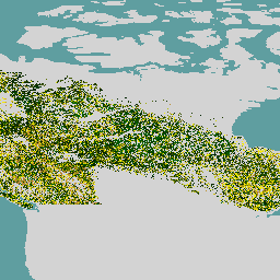
캐나다 원시림 데이터 세트는 30m 공간 해상도로 캐나다의 산림 생태 지역에 걸쳐 2019년의 위성 기반 산림 연령 지도입니다. Landsat (교란, 표면 반사율 합성, 산림 구조) 및 MODIS (총 일차 생산량)의 원격 감지 데이터는 연령을 결정하는 데 사용됩니다.
산림 연령은 교란을 직접 식별할 수 있는 경우(교란 접근 방식) 또는 스펙트럼 정보를 사용하여 추론하는 경우 (회복 접근 방식) 또는 교란의 증거가 없는 경우 연령을 모델링하기 위해 역전된 동종이형 방정식 (동종이형 접근 방식)을 사용하여 결정할 수 있습니다. 교란 접근 방식은 위성 데이터를 기반으로 변경사항을 매핑하며 가장 정확합니다. 복구 접근 방식은 순수 모델링보다 정확도가 높은 위성 데이터와 산림 천이에 관한 논리도 활용합니다.
캐나다의 숲에 최근 광범위한 교란이 없었기 때문에 가장 넓은 지역 (86.6%)에 대해 동종이형 접근 방식이 필요합니다. 실현된 높이와 성장 및 수확량 모델링에 관한 정보를 사용하여 다른 방법으로 불가능한 경우 연령을 추정합니다. 모든 연령대의 나무가 매핑되며 150년이 넘은 나무는 '오래된 나무' 카테고리로 결합됩니다.
대역
대역
픽셀 크기: 30미터 (모든 밴드)
| 이름 | 단위 | 픽셀 크기 | 설명 |
|---|---|---|---|
forest |
y | 30m | 숲 연령 |
이용약관
이용약관
캐나다의 산림 생태계에 대해 여기에 설명된 산림 연령 지도는 오픈소스로 선언되었으며 캐나다 정부에서 지원합니다. 데이터 세트는 CC-BY 4.0 라이선스에 따라 사용이 허가됩니다.
Earth Engine으로 탐색
코드 편집기(JavaScript)
var dataset = ee.ImageCollection('CANADA/NFIS/NTEMS/CA_FOREST_AGE');

Map.setCenter(-107.94, 58.18, 3);
Map.addLayer(
    dataset,
    {palette: ['006600', '002200', 'fff700', 'ab7634', 'c4d0ff', 'ffffff']},
    'Canada Primary Forest Data');