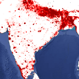
تحتوي مجموعة البيانات هذه على تقديرات لعدد الأشخاص
في كل خلية شبكية تبلغ مساحتها 30 ثانية قوسية، بما يتوافق مع الإحصاءات الوطنية
وسجلات السكان من حيث التوزيع المكاني النسبي، ولكن تم تعديلها
لتتطابق مع المراجعة لعام 2015 لآفاق السكان في العالم الصادرة عن الأمم المتحدة
وإجمالي عدد السكان في البلدان. تتوفّر صورة واحدة لكل سنة تم وضع نموذج لها.
يقدّم الإصدار 11 من "تعداد السكان في العالم" (GPWv4) توزيعًا
للسكان في العالم خلال الأعوام 2000 و2005 و2010 و2015 و2020
في خلايا شبكية تبلغ مساحتها 30 ثانية قوسية (كيلومتر واحد تقريبًا). يتم توزيع السكان على الخلايا باستخدام التوزيع النسبي للسكان من التعداد السكاني والوحدات الإدارية. يتم جمع بيانات السكان المدخلة بأعلى دقة مكانية متاحة من نتائج جولة التعدادات لعام 2010 التي أُجريت بين عامَي 2005 و2014. يتم استقراء بيانات الإدخال لإنتاج تقديرات عدد السكان لكل سنة تم وضع نموذج لها.
النطاقات
حجم البكسل 927.67 متر
النطاقات
الاسم
الحد الأدنى
الحد الأقصى
حجم البكسل
الوصف
unwpp-adjusted_population_density
0*
778120*
أمتار
يشير هذا المقياس إلى العدد المقدَّر للأشخاص في كل كيلومتر مربّع.
مركز شبكة معلومات علوم الأرض الدولية (CIESIN) في "جامعة كولومبيا" 2018 Gridded Population of the World، الإصدار 4
(GPWv4.11): الكثافة السكانية المعدّلة لتتطابق مع المراجعة لعام 2015 من التوقعات السكانية في العالم الصادرة عن الأمم المتحدة
إجمالي عدد السكان في البلدان، المراجعة 11. Palisades, NY: NASA Socioeconomic Data and Applications
Center (SEDAC). https://doi.org/10.7927/H4F47M65.
تم الوصول إليه في DAY MONTH YEAR.
تحتوي مجموعة البيانات هذه على تقديرات لعدد الأشخاص لكل خلية شبكة تبلغ 30 ثانية قوسية، بما يتوافق مع الإحصاءات الوطنية وسجلات السكان فيما يتعلق بالتوزيع المكاني النسبي، ولكن تم تعديلها لتتطابق مع المراجعة لعام 2015 لإجمالي عدد السكان في العالم حسب توقعات الأمم المتحدة. تتوفّر صورة واحدة لكل سنة تم وضع نموذج لها. عام …
[null,null,[],[[["\u003cp\u003eThe Gridded Population of the World, Version 4 (GPWv4), Revision 11, provides estimates of human population density globally for the years 2000, 2005, 2010, 2015, and 2020.\u003c/p\u003e\n"],["\u003cp\u003ePopulation data is modeled on a 30 arc-second (approximately 1km) grid and is based on national censuses and population registers, adjusted to the 2015 Revision of UN World Population Prospects.\u003c/p\u003e\n"],["\u003cp\u003eThe dataset is available through Google Earth Engine and is provided by NASA SEDAC at the Center for International Earth Science Information Network.\u003c/p\u003e\n"],["\u003cp\u003eIt's licensed under CC-BY-4.0 and is free to use for research, education, and non-profit purposes.\u003c/p\u003e\n"]]],[],null,["# GPWv411: UN-Adjusted Population Density (Gridded Population of the World Version 4.11)\n\nDataset Availability\n: 2000-01-01T00:00:00Z--2020-01-01T00:00:00Z\n\nDataset Provider\n:\n\n\n [NASA SEDAC at the Center for International Earth Science Information Network](https://doi.org/10.7927/H4F47M65)\n\nCadence\n: 5 Years\n\nTags\n:\n[ciesin](/earth-engine/datasets/tags/ciesin) [gpw](/earth-engine/datasets/tags/gpw) [nasa](/earth-engine/datasets/tags/nasa) [population](/earth-engine/datasets/tags/population) \n\n#### Description\n\nThis dataset contains estimates of the number of persons\nper 30 arc-second grid cell, consistent with national censuses and\npopulation registers with respect to relative spatial distribution but\nadjusted to match the 2015 Revision of UN World Population Prospects\ncountry totals. There is one image for each modeled year.\n\n[General Documentation](https://sedac.ciesin.columbia.edu/data/set/gpw-v4-population-density-rev11/docs)\n\nThe Gridded Population of World Version 4 (GPWv4), Revision 11 models the distribution\nof global human population for the years 2000, 2005, 2010, 2015, and 2020\non 30 arc-second (approximately 1 km) grid cells. Population is distributed\nto cells using proportional allocation of population from census and\nadministrative units. Population input data are collected at the most\ndetailed spatial resolution available from the results of the 2010 round of\ncensuses, which occurred between 2005 and 2014. The input data are\nextrapolated to produce population estimates for each modeled year.\n\n### Bands\n\n\n**Pixel Size**\n\n927.67 meters\n\n**Bands**\n\n| Name | Min | Max | Pixel Size | Description |\n|-------------------------------------|-----|----------|------------|-------------------------------------------------------|\n| `unwpp-adjusted_population_density` | 0\\* | 778120\\* | meters | The estimated number of persons per square kilometer. |\n\n\\* estimated min or max value\n\n### Terms of Use\n\n**Terms of Use**\n\n[CC-BY-4.0](https://spdx.org/licenses/CC-BY-4.0.html)\n\n### Citations\n\nCitations:\n\n- Center for International Earth Science Information Network - CIESIN -\n Columbia University. 2018. Gridded Population of the World, Version 4\n (GPWv4.11): Population Density Adjusted to Match 2015 Revision of UN WPP\n Country Totals, Revision 11. Palisades, NY: NASA Socioeconomic Data and Applications\n Center (SEDAC). \u003chttps://doi.org/10.7927/H4F47M65\u003e.\n Accessed DAY MONTH YEAR.\n\n### DOIs\n\n- \u003chttps://doi.org/10.7927/H4F47M65\u003e\n\n### Explore with Earth Engine\n\n| **Important:** Earth Engine is a platform for petabyte-scale scientific analysis and visualization of geospatial datasets, both for public benefit and for business and government users. Earth Engine is free to use for research, education, and nonprofit use. To get started, please [register for Earth Engine access.](https://console.cloud.google.com/earth-engine)\n\n### Code Editor (JavaScript)\n\n```javascript\nvar dataset = ee.ImageCollection('CIESIN/GPWv411/GPW_UNWPP-Adjusted_Population_Density').first();\nvar raster = dataset.select('unwpp-adjusted_population_density');\nvar raster_vis = {\n 'max': 1000.0,\n 'palette': [\n 'ffffe7',\n 'FFc869',\n 'ffac1d',\n 'e17735',\n 'f2552c',\n '9f0c21'\n ],\n 'min': 0.0\n};\nMap.setCenter(79.1, 19.81, 3);\nMap.addLayer(raster, raster_vis, 'unwpp-adjusted_population_density');\n```\n[Open in Code Editor](https://code.earthengine.google.com/?scriptPath=Examples:Datasets/CIESIN/CIESIN_GPWv411_GPW_UNWPP-Adjusted_Population_Density) \n[GPWv411: UN-Adjusted Population Density (Gridded Population of the World Version 4.11)](/earth-engine/datasets/catalog/CIESIN_GPWv411_GPW_UNWPP-Adjusted_Population_Density) \nThis dataset contains estimates of the number of persons per 30 arc-second grid cell, consistent with national censuses and population registers with respect to relative spatial distribution but adjusted to match the 2015 Revision of UN World Population Prospects country totals. There is one image for each modeled year. General ... \nCIESIN/GPWv411/GPW_UNWPP-Adjusted_Population_Density, ciesin,gpw,nasa,population \n2000-01-01T00:00:00Z/2020-01-01T00:00:00Z \n-90 -180 90 180 \nGoogle Earth Engine \nhttps://developers.google.com/earth-engine/datasets\n\n- [https://doi.org/10.7927/H4F47M65](https://doi.org/https://doi.org/10.7927/H4F47M65)\n- [https://doi.org/10.7927/H4F47M65](https://doi.org/https://developers.google.com/earth-engine/datasets/catalog/CIESIN_GPWv411_GPW_UNWPP-Adjusted_Population_Density)"]]