- Disponibilidade de conjuntos de dados
- 2000-01-01T00:00:00Z–2020-01-01T00:00:00Z
- Provedor de conjunto de dados
- NASA SEDAC no Center for International Earth Science Information Network
- Cadência
- 5 anos
- Tags
Descrição
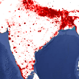
Esse conjunto de dados contém estimativas do número de pessoas por célula de grade de 30 segundos de arco, de acordo com os censos nacionais e os registros de população em relação à distribuição espacial relativa, mas ajustado para corresponder aos totais de países da Revisão de 2015 das Perspectivas da população mundial da ONU. Há uma imagem para cada ano modelado.
A versão 4 da população em grade do mundo (GPWv4), revisão 11, modela a distribuição da população humana global para os anos de 2000, 2005, 2010, 2015 e 2020 em células de grade de 30 segundos de arco (aproximadamente 1 km). A população é distribuída para células usando a alocação proporcional de população de unidades administrativas e do censo. Os dados de entrada da população são coletados na resolução espacial mais detalhada disponível nos resultados da rodada de censos de 2010, que ocorreu entre 2005 e 2014. Os dados de entrada são extrapolados para produzir estimativas de população para cada ano modelado.
Bandas
Tamanho do pixel
927,67 metros
Bandas
| Nome | Mín. | Máx. | Tamanho do pixel | Descrição |
|---|---|---|---|---|
unwpp-adjusted_population_density |
0* | 778120* | metros | O número estimado de pessoas por quilômetro quadrado. |
Termos de Uso
Termos de Uso
Citações
Center for International Earth Science Information Network - CIESIN - Columbia University. 2018. Gridded Population of the World, Version 4 (GPWv4.11): Population Density Adjusted to Match 2015 Revision of UN WPP Country Totals, Revision 11. Palisades, NY: NASA Socioeconomic Data and Applications Center (SEDAC). https://doi.org/10.7927/H4F47M65. Acessado em DIA MÊS ANO.
DOIs
Explorar com o Earth Engine
Editor de código (JavaScript)
var dataset = ee.ImageCollection('CIESIN/GPWv411/GPW_UNWPP-Adjusted_Population_Density').first();
var raster = dataset.select('unwpp-adjusted_population_density');
var raster_vis = {
  'max': 1000.0,
  'palette': [
    'ffffe7',
    'FFc869',
    'ffac1d',
    'e17735',
    'f2552c',
    '9f0c21'
  ],
  'min': 0.0
};
Map.setCenter(79.1, 19.81, 3);
Map.addLayer(raster, raster_vis, 'unwpp-adjusted_population_density');