- Доступность набора данных
- 2010-07-01T00:00:00Z–2016-07-01T00:00:00Z
- Поставщик наборов данных
- CPOM
- Теги
- cpom
Описание
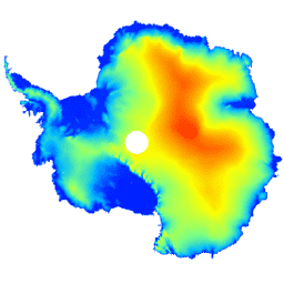
Этот набор данных представляет собой цифровую модель рельефа (ЦМР) Антарктического ледяного щита и шельфовых ледников, основанную на наблюдениях, зарегистрированных спутниковым радиолокационным высотомером CryoSat-2 в период с июля 2010 года по июль 2016 года.
ЦМР формируется на основе пространственно-временных аппроксимаций данных измерений высоты, собранных в ячейках сетки с шагом 1, 2 и 5 км, и публикуется с модальным разрешением 1 км. Медианное и среднеквадратичное отклонение между ЦМР и измерениями, полученными с помощью бортового лазерного высотомера (2,3*10 7 ) , полученными в ходе кампаний NASA Operation IceBridge, составляет -0,30 и 13,50 м соответственно.
Неопределенность ЦМР возрастает в областях с большим уклоном, особенно там, где измерения высоты проводились в режиме низкого разрешения; принимая это во внимание, мы оцениваем среднюю точность в 9,5 м.
Группы
Размер пикселя
1000 метров
Группы
| Имя | Единицы | Размер пикселя | Описание |
|---|---|---|---|
elevation | м | метров | Высота антарктического ледяного щита и шельфового ледника. |
data_composition | метров | Метод обработки данных по высоте ячейки сетки. | |
slope | град | метров | Уклон определяется градиентом высоты. |
z_smoothed | м | метров | Сглаженная версия модели рельефа с использованием медианного фильтра. |
z_uncertainty | м | метров | Достоверность модели рельефа, полученной на основе среднеквадратичного отклонения высот в наблюдаемых ячейках сетки и ошибки дисперсии кригинга в интерполированных ячейках сетки. |
Таблица классов data_composition
| Ценить | Цвет | Описание |
|---|---|---|
| 0 | #000000 | интерполированный |
| 1 | #cbcbcb | 1 км подходит |
| 2 | #377eb7 | повторная выборка 2 км |
| 3 | #e2191b | повторная выборка 5 км |
Условия эксплуатации
Условия эксплуатации
Цитаты
Слейтер, Т., Шепард, А., Макмиллан, М., Мьюир, А., Гилберт, Л., Хогг, А.Е., Конрад, Х. и Парринелло, Т.: Новая цифровая модель рельефа Антарктиды, полученная на основе данных альтиметрии CryoSat-2, Криосфера, doi:10.5194/tc-2017-223 , 2018
DOI
Исследуйте с Earth Engine
Редактор кода (JavaScript)
var dataset = ee.Image('CPOM/CryoSat2/ANTARCTICA_DEM');

var visualization = {
  bands: ['elevation'],
  min: 0.0,
  max: 4000.0,
  palette: ['001fff', '00ffff', 'fbff00', 'ff0000']
};

Map.setCenter(17.0, -76.0, 3);

Map.addLayer(dataset, visualization, 'Elevation');