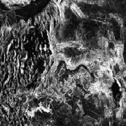
지형 다양성 (D)은 종이 지역 서식지로 이용할 수 있는 다양한 온도 및 습도 조건을 나타내는 대리 변수입니다. 이는 다양한 지형 기후 니치가 더 높은 다양성 (특히 식물)을 지원하고 기후 변화를 고려할 때 종의 지속성을 지원해야 한다는 논리를 나타냅니다.
D를 계산하기 위해 토양 수분 (T)의 지배적인 제어인 다중 스케일 지형 위치 지수 (mTPI)가 언덕 경사면 위치를 측정하는 데 사용되었습니다. mTPI는 mTPI>0 (T')의 제곱근 변환과 여러 스케일에서 계산된 연속 열-절연 부하 지수 (CHILI)의 표준 편차 (C')와 결합되었습니다. D = 1 - ((1-T') * (1-C')). JAXA의 ALOS DEM (EE에서 JAXA/ALOS/AW3D30_V1_1로 사용 가능)의 30m 'AVE' 밴드를 기반으로 합니다.
Conservation Science Partners (CSP)의 생태학적으로 관련된 지형학(ERGo) 데이터 세트, 지형 및 지형학에는 지형 및 지형학 (즉, 토지 패싯) 패턴에 관한 상세한 다중 스케일 데이터가 포함되어 있습니다. 이러한 데이터는 다양한 용도로 사용될 수 있지만, 원래 목적은 기후 적응 계획에 적합한 지형 및 지형학적 분류와 지도를 개발하는 것이었습니다. 미래 기후 조건과 생태학적 반응에 대한 불확실성이 크기 때문에 변화가 없을 가능성이 높은 요소에 관한 정보를 제공하면 관리자가 강력한 기후 적응 계획을 수립할 수 있는 강력한 기반이 됩니다. 이러한 지형의 특징은 해상도에 민감하므로 특정 지수의 범위와 특성을 고려하여 가능한 가장 높은 해상도를 제공합니다.
[null,null,[],[[["\u003cp\u003eThe dataset provides a global, ALOS-derived topographic diversity index at a 270-meter resolution, representing the variety of temperature and moisture conditions available to species.\u003c/p\u003e\n"],["\u003cp\u003eTopographic diversity is calculated using a combination of multi-scale Topographic Position Index (mTPI) and Continuous Heat-Insolation Load Index (CHILI) to represent the variety of topo-climate niches.\u003c/p\u003e\n"],["\u003cp\u003eThis dataset, developed by Conservation Science Partners, was created for climate adaptation planning and ecological relevance with landforms and physiographic patterns.\u003c/p\u003e\n"],["\u003cp\u003eThe data is based on the 30m "AVE" band of JAXA's ALOS DEM and is available under the CC-BY-NC-SA-4.0 license.\u003c/p\u003e\n"],["\u003cp\u003eThe dataset covers the period from January 24, 2006, to May 13, 2011.\u003c/p\u003e\n"]]],["The dataset, provided by Conservation Science Partners, contains global topographic diversity data from 2006 to 2011. It uses a calculation (D) based on multi-scale Topographic Position Index (mTPI) and the Continuous Heat-Insolation Load Index (CHILI) to represent the variety of temperature and moisture conditions for species habitats. The data, derived from JAXA's ALOS DEM, is available in Earth Engine as an image ('constant' band) with a 270-meter pixel size and is intended for climate adaptation planning.\n"],null,["# Global ALOS Topographic Diversity\n\nDataset Availability\n: 2006-01-24T00:00:00Z--2011-05-13T00:00:00Z\n\nDataset Provider\n:\n\n\n [Conservation Science Partners](https://www.csp-inc.org/)\n\nTags\n:\n[aspect](/earth-engine/datasets/tags/aspect) [csp](/earth-engine/datasets/tags/csp) [elevation](/earth-engine/datasets/tags/elevation) [elevation-topography](/earth-engine/datasets/tags/elevation-topography) [ergo](/earth-engine/datasets/tags/ergo) [geophysical](/earth-engine/datasets/tags/geophysical) [global](/earth-engine/datasets/tags/global) [landforms](/earth-engine/datasets/tags/landforms) [slope](/earth-engine/datasets/tags/slope) [topography](/earth-engine/datasets/tags/topography) \n\n#### Description\n\nTopographic diversity (D) is a surrogate variable that represents the\nvariety of temperature and moisture conditions available to species as local\nhabitats. It expresses the logic that a higher variety of topo-climate\nniches should support higher diversity (especially plant) and support\nspecies persistence given climatic change.\n\nTo calculate D, the multi-scale Topographic Position Index (mTPI), being a\ndominant control of soil moisture (T), was used for measuring hillslope\nposition. The mTPI was combined with the square-root transform for\nmTPI\\\u003e0 (T') and with the standard deviation of the Continuous\nHeat-Insolation Load Index (CHILI), calculated at multiple scales (C') as:\nD = 1 - ((1-T') \\* (1-C'). It is based on the 30m \"AVE\" band of JAXA's ALOS\nDEM (available in EE as JAXA/ALOS/AW3D30_V1_1).\n\nThe Conservation Science Partners (CSP) Ecologically Relevant Geomorphology\n(ERGo) Datasets, Landforms and Physiography contain detailed, multi-scale\ndata on landforms and physiographic (aka land facet) patterns. Although\nthere are many potential uses of these data, the original purpose for these\ndata was to develop an ecologically relevant classification and map of\nlandforms and physiographic classes that are suitable for climate adaptation\nplanning. Because there is large uncertainty associated with future climate\nconditions and even more uncertainty around ecological responses, providing\ninformation about what is unlikely to change offers a strong foundation for\nmanagers to build robust climate adaptation plans. The quantification of\nthese features of the landscape is sensitive to the resolution, so we\nprovide the highest resolution possible given the extent and characteristics\nof a given index.\n\n### Bands\n\n\n**Pixel Size**\n\n270 meters\n\n**Bands**\n\n| Name | Min | Max | Pixel Size | Description |\n|------------|-----|-----|------------|------------------------------------|\n| `constant` | 0\\* | 1\\* | meters | ALOS-derived topographic diversity |\n\n\\* estimated min or max value\n\n### Terms of Use\n\n**Terms of Use**\n\n[CC-BY-NC-SA-4.0](https://spdx.org/licenses/CC-BY-NC-SA-4.0.html)\n\n### Citations\n\nCitations:\n\n- Theobald, D. M., Harrison-Atlas, D., Monahan, W. B., \\& Albano, C. M.\n (2015). Ecologically-relevant maps of landforms and physiographic diversity\n for climate adaptation planning. PloS one, 10(12),\n [e0143619](https://journals.plos.org/plosone/article?id=10.1371/journal.pone.0143619)\n\n### Explore with Earth Engine\n\n| **Important:** Earth Engine is a platform for petabyte-scale scientific analysis and visualization of geospatial datasets, both for public benefit and for business and government users. Earth Engine is free to use for research, education, and nonprofit use. To get started, please [register for Earth Engine access.](https://console.cloud.google.com/earth-engine)\n\n### Code Editor (JavaScript)\n\n```javascript\nvar dataset = ee.Image('CSP/ERGo/1_0/Global/ALOS_topoDiversity');\nvar alosTopographicDiversity = dataset.select('constant');\nvar alosTopographicDiversityVis = {\n min: 0.0,\n max: 1.0,\n};\nMap.setCenter(-111.313, 39.724, 6);\nMap.addLayer(\n alosTopographicDiversity, alosTopographicDiversityVis,\n 'ALOS Topographic Diversity');\n```\n[Open in Code Editor](https://code.earthengine.google.com/?scriptPath=Examples:Datasets/CSP/CSP_ERGo_1_0_Global_ALOS_topoDiversity) \n[Global ALOS Topographic Diversity](/earth-engine/datasets/catalog/CSP_ERGo_1_0_Global_ALOS_topoDiversity) \nTopographic diversity (D) is a surrogate variable that represents the variety of temperature and moisture conditions available to species as local habitats. It expresses the logic that a higher variety of topo-climate niches should support higher diversity (especially plant) and support species persistence given climatic change. To calculate D, the ... \nCSP/ERGo/1_0/Global/ALOS_topoDiversity, aspect,csp,elevation,elevation-topography,ergo,geophysical,global,landforms,slope,topography \n2006-01-24T00:00:00Z/2011-05-13T00:00:00Z \n-90 -180 90 180 \nGoogle Earth Engine \nhttps://developers.google.com/earth-engine/datasets\n\n- [](https://doi.org/https://www.csp-inc.org/)\n- [](https://doi.org/https://developers.google.com/earth-engine/datasets/catalog/CSP_ERGo_1_0_Global_ALOS_topoDiversity)"]]