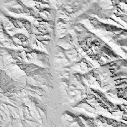
CHILI는 초오후에 일사량을 계산하여 나타낸 증발산에 대한 일사량 및 지형 음영의 효과를 대체합니다. 이때 태양 고도는 춘분과 동일합니다. 30m SRTM DEM(EE에서 USGS/SRTMGL1_003으로 사용 가능)을 기반으로 합니다.
Conservation Science Partners (CSP)의 생태학적으로 관련된 지형학(ERGo) 데이터 세트, 지형 및 지형학에는 지형 및 지형학 (즉, 토지 패싯) 패턴에 관한 상세한 다중 스케일 데이터가 포함되어 있습니다. 이러한 데이터는 다양한 용도로 사용될 수 있지만, 원래 목적은 기후 적응 계획에 적합한 지형 및 지형학적 분류와 지도를 개발하는 것이었습니다. 미래 기후 조건과 생태학적 반응에 대한 불확실성이 크기 때문에 변화가 없을 가능성이 높은 요소에 관한 정보를 제공하면 관리자가 강력한 기후 적응 계획을 수립할 수 있는 강력한 기반이 됩니다. 이러한 지형의 특징은 해상도에 민감하므로 특정 지수의 범위와 특성을 고려하여 가능한 가장 높은 해상도를 제공합니다.
대역
픽셀 크기 90미터
대역
이름
최소
최대
픽셀 크기
설명
constant
0
255
미터
SRTM에서 파생된 CHILI 지수로, 0 (매우 시원함)에서 255(매우 따뜻함)까지의 범위를 갖습니다. 게시물의 [0,1] 범위에서 다시 조정되었습니다.
CHILI는 초오후의 일사량, 춘분과 동일한 태양 고도를 계산하여 나타낸 증발산에 대한 일사량 및 지형 음영의 대리 변수입니다. 30m SRTM DEM (EE에서 USGS/SRTMGL1_003으로 사용 가능)을 기반으로 합니다. 보존 과학 파트너 (CSP) 생태학적으로 관련된 지형학 (ERGo) 데이터 세트, 지형 및 …
[null,null,[],[[["\u003cp\u003eThe SRTM CHILI dataset provides a global index of heat-insolation load, ranging from 0 (very cool) to 255 (very warm), derived from the SRTM DEM.\u003c/p\u003e\n"],["\u003cp\u003eThis dataset, developed by Conservation Science Partners, is intended for climate adaptation planning and ecological analysis.\u003c/p\u003e\n"],["\u003cp\u003eCHILI represents the effects of insolation and topographic shading on evapotranspiration, calculated at early afternoon sun altitude equivalent to equinox.\u003c/p\u003e\n"],["\u003cp\u003eIt is available at a 90-meter resolution and covers the period from January 24, 2006, to May 13, 2011.\u003c/p\u003e\n"],["\u003cp\u003eThe data is licensed under CC-BY-NC-SA-4.0.\u003c/p\u003e\n"]]],["The dataset, available from 2006-01-24 to 2011-05-13, provided by Conservation Science Partners, features the SRTM-derived CHILI index within the ERGo dataset. CHILI, a measure of insolation's impact on evapotranspiration, ranges from 0 (cool) to 255 (warm), based on a 30m SRTM DEM. Accessible via Earth Engine, it offers landform and physiographic data for climate adaptation planning. The pixel size is 90 meters and is offered under a CC-BY-NC-SA-4.0 license.\n"],null,["# Global SRTM CHILI (Continuous Heat-Insolation Load Index)\n\nDataset Availability\n: 2006-01-24T00:00:00Z--2011-05-13T00:00:00Z\n\nDataset Provider\n:\n\n\n [Conservation Science Partners](https://www.csp-inc.org/)\n\nTags\n:\n[aspect](/earth-engine/datasets/tags/aspect) [csp](/earth-engine/datasets/tags/csp) [elevation](/earth-engine/datasets/tags/elevation) [elevation-topography](/earth-engine/datasets/tags/elevation-topography) [ergo](/earth-engine/datasets/tags/ergo) [geophysical](/earth-engine/datasets/tags/geophysical) [global](/earth-engine/datasets/tags/global) [landforms](/earth-engine/datasets/tags/landforms) [slope](/earth-engine/datasets/tags/slope) [topography](/earth-engine/datasets/tags/topography) \n\n#### Description\n\nCHILI is a surrogate for effects of insolation and topographic shading on\nevapotranspiration represented by calculating insolation at early afternoon,\nsun altitude equivalent to equinox. It is based on the 30m SRTM DEM\n(available in EE as USGS/SRTMGL1_003).\n\nThe Conservation Science Partners (CSP) Ecologically Relevant Geomorphology\n(ERGo) Datasets, Landforms and Physiography contain detailed, multi-scale\ndata on landforms and physiographic (aka land facet) patterns. Although\nthere are many potential uses of these data, the original purpose for these\ndata was to develop an ecologically relevant classification and map of\nlandforms and physiographic classes that are suitable for climate adaptation\nplanning. Because there is large uncertainty associated with future climate\nconditions and even more uncertainty around ecological responses, providing\ninformation about what is unlikely to change offers a strong foundation for\nmanagers to build robust climate adaptation plans. The quantification of\nthese features of the landscape is sensitive to the resolution, so we\nprovide the highest resolution possible given the extent and characteristics\nof a given index.\n\n### Bands\n\n\n**Pixel Size**\n\n90 meters\n\n**Bands**\n\n| Name | Min | Max | Pixel Size | Description |\n|------------|-----|-----|------------|--------------------------------------------------------------------------------------------------------------------------------------|\n| `constant` | 0 | 255 | meters | SRTM-derived CHILI index ranging from 0 (very cool) to 255 (very warm). This was rescaled from the \\[0,1\\] range in the publication. |\n\n### Terms of Use\n\n**Terms of Use**\n\n[CC-BY-NC-SA-4.0](https://spdx.org/licenses/CC-BY-NC-SA-4.0.html)\n\n### Citations\n\nCitations:\n\n- Theobald, D. M., Harrison-Atlas, D., Monahan, W. B., \\& Albano, C. M.\n (2015). Ecologically-relevant maps of landforms and physiographic diversity\n for climate adaptation planning. PloS one, 10(12),\n [e0143619](https://journals.plos.org/plosone/article?id=10.1371/journal.pone.0143619)\n\n### Explore with Earth Engine\n\n| **Important:** Earth Engine is a platform for petabyte-scale scientific analysis and visualization of geospatial datasets, both for public benefit and for business and government users. Earth Engine is free to use for research, education, and nonprofit use. To get started, please [register for Earth Engine access.](https://console.cloud.google.com/earth-engine)\n\n### Code Editor (JavaScript)\n\n```javascript\nvar dataset = ee.Image('CSP/ERGo/1_0/Global/SRTM_CHILI');\nvar srtmChili = dataset.select('constant');\nvar srtmChiliVis = {\n min: 0.0,\n max: 255.0,\n};\nMap.setCenter(-105.8636, 40.3439, 11);\nMap.addLayer(srtmChili, srtmChiliVis, 'SRTM CHILI');\n```\n[Open in Code Editor](https://code.earthengine.google.com/?scriptPath=Examples:Datasets/CSP/CSP_ERGo_1_0_Global_SRTM_CHILI) \n[Global SRTM CHILI (Continuous Heat-Insolation Load Index)](/earth-engine/datasets/catalog/CSP_ERGo_1_0_Global_SRTM_CHILI) \nCHILI is a surrogate for effects of insolation and topographic shading on evapotranspiration represented by calculating insolation at early afternoon, sun altitude equivalent to equinox. It is based on the 30m SRTM DEM (available in EE as USGS/SRTMGL1_003). The Conservation Science Partners (CSP) Ecologically Relevant Geomorphology (ERGo) Datasets, Landforms and ... \nCSP/ERGo/1_0/Global/SRTM_CHILI, aspect,csp,elevation,elevation-topography,ergo,geophysical,global,landforms,slope,topography \n2006-01-24T00:00:00Z/2011-05-13T00:00:00Z \n-90 -180 90 180 \nGoogle Earth Engine \nhttps://developers.google.com/earth-engine/datasets\n\n- [](https://doi.org/https://www.csp-inc.org/)\n- [](https://doi.org/https://developers.google.com/earth-engine/datasets/catalog/CSP_ERGo_1_0_Global_SRTM_CHILI)"]]