- در دسترس بودن مجموعه دادهها
- ۲۰۰۶-۰۱-۲۴T۰۰:۰۰:۰۰Z–۲۰۱۱-۰۵-۱۳T۰۰:۰۰:۰۰Z
- تولیدکننده مجموعه داده
- شرکای علمی حفاظت
- برچسبها
توضیحات
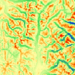
mTPI اشکال پشته را از دره متمایز میکند. این شاخص با استفاده از دادههای ارتفاعی برای هر مکان و تفریق آن از میانگین ارتفاع در یک محله محاسبه میشود. mTPI از پنجرههای متحرک با شعاع (کیلومتر) استفاده میکند: ۱۱۵.۸، ۸۹.۹، ۳۵.۵، ۱۳.۱، ۵.۶، ۲.۸ و ۱.۲. این شاخص بر اساس DEM 30 متری SRTM (موجود در EE با نام USGS/SRTMGL1_003) است.
مجموعه دادههای ژئومورفولوژی، لندفرمها و فیزیوگرافی مرتبط با اکولوژی (ERGo) شرکای علوم حفاظت (CSP) حاوی دادههای دقیق و چندمقیاسی در مورد لندفرمها و الگوهای فیزیوگرافی (معروف به وجه زمین) هستند. اگرچه کاربردهای بالقوه زیادی برای این دادهها وجود دارد، هدف اصلی این دادهها، توسعه یک طبقهبندی و نقشه مرتبط با اکولوژی از لندفرمها و طبقات فیزیوگرافی بود که برای برنامهریزی سازگاری با آب و هوا مناسب باشند. از آنجا که عدم قطعیت زیادی در ارتباط با شرایط آب و هوایی آینده و حتی عدم قطعیت بیشتر در مورد پاسخهای اکولوژیکی وجود دارد، ارائه اطلاعات در مورد آنچه بعید است تغییر کند، پایه محکمی را برای مدیران فراهم میکند تا برنامههای سازگاری با آب و هوا قوی ایجاد کنند. کمیسازی این ویژگیهای چشمانداز به وضوح تصویر حساس است، بنابراین ما با توجه به وسعت و ویژگیهای یک شاخص معین، بالاترین وضوح ممکن را ارائه میدهیم.
باندها
باندها
اندازه پیکسل: ۲۷۰ متر (همه باندها)
| نام | واحدها | حداقل | مکس | اندازه پیکسل | توضیحات |
|---|---|---|---|---|---|
elevation | متر | -۸۱۲۹* | ۷۹۰۵* | ۲۷۰ متر | mTPI مشتقشده از SRTM که از مقادیر منفی (درهها) تا مقادیر مثبت (برآمدگیها) متغیر است |
شرایط استفاده
شرایط استفاده
نقل قولها
تئوبالد، دیام، هریسون-اطلس، دی.، موناهان، دبلیوبی، و آلبانو، سیام (2015). نقشههای مرتبط با بومشناسی از لندفرمها و تنوع فیزیوگرافی برای برنامهریزی سازگاری با آب و هوا. PloS one، 10(12)، e0143619
با موتور زمین کاوش کنید
ویرایشگر کد (جاوااسکریپت)
var dataset = ee.Image('CSP/ERGo/1_0/Global/SRTM_mTPI');
var srtmMtpi = dataset.select('elevation');
var srtmMtpiVis = {
  min: -200.0,
  max: 200.0,
  palette: ['0b1eff', '4be450', 'fffca4', 'ffa011', 'ff0000'],
};
Map.setCenter(-105.8636, 40.3439, 11);
Map.addLayer(srtmMtpi, srtmMtpiVis, 'SRTM mTPI');