- در دسترس بودن مجموعه دادهها
- ۲۰۰۶-۰۱-۲۴T۰۰:۰۰:۰۰Z–۲۰۱۱-۰۵-۱۳T۰۰:۰۰:۰۰Z
- تولیدکننده مجموعه داده
- شرکای علمی حفاظت
- برچسبها
توضیحات
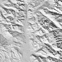
CHILI جایگزینی برای اثرات تابش خورشید و سایه توپوگرافی بر تبخیر و تعرق است که با محاسبه تابش خورشید در اوایل بعد از ظهر، ارتفاع خورشید معادل اعتدالین، نشان داده میشود. این مدل بر اساس DEM 10 متری NED متعلق به USGS (که در EE با عنوان USGS/NED موجود است) میباشد.
مجموعه دادههای ژئومورفولوژی، لندفرمها و فیزیوگرافی مرتبط با اکولوژی (ERGo) شرکای علوم حفاظت (CSP) حاوی دادههای دقیق و چندمقیاسی در مورد لندفرمها و الگوهای فیزیوگرافی (معروف به وجه زمین) هستند. اگرچه کاربردهای بالقوه زیادی برای این دادهها وجود دارد، هدف اصلی این دادهها، توسعه یک طبقهبندی و نقشه مرتبط با اکولوژی از لندفرمها و طبقات فیزیوگرافی بود که برای برنامهریزی سازگاری با آب و هوا مناسب باشند. از آنجا که عدم قطعیت زیادی در ارتباط با شرایط آب و هوایی آینده و حتی عدم قطعیت بیشتر در مورد پاسخهای اکولوژیکی وجود دارد، ارائه اطلاعات در مورد آنچه بعید است تغییر کند، پایه محکمی را برای مدیران فراهم میکند تا برنامههای سازگاری با آب و هوا قوی ایجاد کنند. کمیسازی این ویژگیهای چشمانداز به وضوح تصویر حساس است، بنابراین ما با توجه به وسعت و ویژگیهای یک شاخص معین، بالاترین وضوح ممکن را ارائه میدهیم.
باندها
باندها
اندازه پیکسل: ۱۰ متر (همه باندها)
| نام | حداقل | مکس | اندازه پیکسل | توضیحات |
|---|---|---|---|---|
constant | 0 | ۲۵۵ | ۱۰ متر | شاخص چیلی (CHILI) مشتق شده از NED که از 0 (خیلی سرد) تا 255 (خیلی گرم) متغیر است. این شاخص از محدوده [0،1] در نشریه تغییر مقیاس داده شده است. |
شرایط استفاده
شرایط استفاده
نقل قولها
تئوبالد، دیام، هریسون-اطلس، دی.، موناهان، دبلیوبی، و آلبانو، سیام (2015). نقشههای مرتبط با بومشناسی از لندفرمها و تنوع فیزیوگرافی برای برنامهریزی سازگاری با آب و هوا. PloS one، 10(12)، e0143619
با موتور زمین کاوش کنید
ویرایشگر کد (جاوااسکریپت)
var dataset = ee.Image('CSP/ERGo/1_0/US/CHILI');
var usChili = dataset.select('constant');
var usChiliVis = {
  min: 0.0,
  max: 255.0,
};
Map.setCenter(-105.8636, 40.3439, 11);
Map.addLayer(usChili, usChiliVis, 'US CHILI');