Zbiór danych ALOS Landform zawiera klasy ukształtowania terenu utworzone przez połączenie zbiorów danych Continuous Heat-Insolation Load Index (CHILI) i multi-scale Topographic Position Index (mTPI). Jest on oparty na modelu DEM NED o rozdzielczości 10 m od USGS (dostępnym w EE jako USGS/NED).
Zbiory danych Conservation Science Partners (CSP) Ecologically Relevant Geomorphology (ERGo), Landforms and Physiography zawierają szczegółowe dane wieloskalowe dotyczące form terenu i wzorców fizjograficznych (czyli aspektów terenu). Chociaż dane te można wykorzystać na wiele sposobów, ich pierwotnym celem było opracowanie istotnej z ekologicznego punktu widzenia klasyfikacji i mapy form terenu oraz klas fizjograficznych, które nadają się do planowania adaptacji do zmian klimatu. Przyszłe warunki klimatyczne są obarczone dużą niepewnością, a reakcje ekologiczne są jeszcze bardziej niepewne. Dlatego informacje o tym, co prawdopodobnie się nie zmieni, stanowią solidną podstawę do opracowywania przez menedżerów solidnych planów adaptacji do zmian klimatu. Kwantyfikacja tych cech krajobrazu jest wrażliwa na rozdzielczość, dlatego podajemy najwyższą możliwą rozdzielczość, biorąc pod uwagę zakres i charakterystykę danego indeksu.
Theobald, D. M., Harrison-Atlas, D., Monahan, W. B., & Albano, C. M.
(2015). Mapy form terenu i różnorodności fizjograficznej istotne z ekologicznego punktu widzenia na potrzeby planowania adaptacji do zmian klimatu. PloS one, 10(12),
e0143619
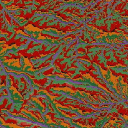
Zbiór danych ALOS Landform zawiera klasy form terenu utworzone przez połączenie zbiorów danych Continuous Heat-Insolation Load Index (CHILI) i multi-scale Topographic Position Index (mTPI). Jest on oparty na modelu DEM NED o rozdzielczości 10 m (dostępnym w EE jako USGS/NED). Zbiory danych Conservation Science Partners (CSP) Ecologically Relevant Geomorphology (ERGo), Landforms and …
[null,null,[],[[["\u003cp\u003eThe ALOS Landform dataset provides landform classes by combining CHILI and mTPI datasets, based on the USGS's 10m NED DEM.\u003c/p\u003e\n"],["\u003cp\u003eThe dataset was developed for climate adaptation planning by classifying landforms and physiographic patterns.\u003c/p\u003e\n"],["\u003cp\u003eIt offers 10-meter resolution and includes 15 distinct landform classes, such as peaks, ridges, slopes, and valleys.\u003c/p\u003e\n"],["\u003cp\u003eThe dataset is provided by Conservation Science Partners and is licensed under CC-BY-NC-SA-4.0.\u003c/p\u003e\n"],["\u003cp\u003eIt covers the United States and is available in Google Earth Engine for analysis and visualization.\u003c/p\u003e\n"]]],[],null,["# US NED Landforms\n\nDataset Availability\n: 2006-01-24T00:00:00Z--2011-05-13T00:00:00Z\n\nDataset Provider\n:\n\n\n [Conservation Science Partners](https://www.csp-inc.org/)\n\nTags\n:\n[aspect](/earth-engine/datasets/tags/aspect) [csp](/earth-engine/datasets/tags/csp) [elevation](/earth-engine/datasets/tags/elevation) [elevation-topography](/earth-engine/datasets/tags/elevation-topography) [ergo](/earth-engine/datasets/tags/ergo) [geophysical](/earth-engine/datasets/tags/geophysical) [landforms](/earth-engine/datasets/tags/landforms) [slope](/earth-engine/datasets/tags/slope) [topography](/earth-engine/datasets/tags/topography) [us](/earth-engine/datasets/tags/us) \n\n#### Description\n\nThe ALOS Landform dataset provides landform classes created by combining\nthe Continuous Heat-Insolation Load Index (CHILI) and the\nmulti-scale Topographic Position Index (mTPI) datasets. It is\nbased on the USGS's 10m NED DEM (available in EE as USGS/NED).\n\nThe Conservation Science Partners (CSP) Ecologically Relevant Geomorphology\n(ERGo) Datasets, Landforms and Physiography contain detailed, multi-scale\ndata on landforms and physiographic (aka land facet) patterns. Although\nthere are many potential uses of these data, the original purpose for these\ndata was to develop an ecologically relevant classification and map of\nlandforms and physiographic classes that are suitable for climate adaptation\nplanning. Because there is large uncertainty associated with future climate\nconditions and even more uncertainty around ecological responses, providing\ninformation about what is unlikely to change offers a strong foundation for\nmanagers to build robust climate adaptation plans. The quantification of\nthese features of the landscape is sensitive to the resolution, so we\nprovide the highest resolution possible given the extent and characteristics\nof a given index.\n\n### Bands\n\n\n**Pixel Size**\n\n10 meters\n\n**Bands**\n\n| Name | Pixel Size | Description |\n|------------|------------|------------------------------|\n| `constant` | meters | NED-derived landform classes |\n\n**constant Class Table**\n\n| Value | Color | Description |\n|-------|---------|--------------------|\n| 11 | #141414 | Peak/ridge (warm) |\n| 12 | #383838 | Peak/ridge |\n| 13 | #808080 | Peak/ridge (cool) |\n| 14 | #ebeb8f | Mountain/divide |\n| 15 | #f7d311 | Cliff |\n| 21 | #aa0000 | Upper slope (warm) |\n| 22 | #d89382 | Upper slope |\n| 23 | #ddc9c9 | Upper slope (cool) |\n| 24 | #dccdce | Upper slope (flat) |\n| 31 | #1c6330 | Lower slope (warm) |\n| 32 | #68aa63 | Lower slope |\n| 33 | #b5c98e | Lower slope (cool) |\n| 34 | #e1f0e5 | Lower slope (flat) |\n| 41 | #a975ba | Valley |\n| 42 | #6f198c | Valley (narrow) |\n\n### Terms of Use\n\n**Terms of Use**\n\n[CC-BY-NC-SA-4.0](https://spdx.org/licenses/CC-BY-NC-SA-4.0.html)\n\n### Citations\n\nCitations:\n\n- Theobald, D. M., Harrison-Atlas, D., Monahan, W. B., \\& Albano, C. M.\n (2015). Ecologically-relevant maps of landforms and physiographic diversity\n for climate adaptation planning. PloS one, 10(12),\n [e0143619](https://journals.plos.org/plosone/article?id=10.1371/journal.pone.0143619)\n\n### Explore with Earth Engine\n\n| **Important:** Earth Engine is a platform for petabyte-scale scientific analysis and visualization of geospatial datasets, both for public benefit and for business and government users. Earth Engine is free to use for research, education, and nonprofit use. To get started, please [register for Earth Engine access.](https://console.cloud.google.com/earth-engine)\n\n### Code Editor (JavaScript)\n\n```javascript\nvar dataset = ee.Image('CSP/ERGo/1_0/US/landforms');\nvar landforms = dataset.select('constant');\nvar landformsVis = {\n min: 11.0,\n max: 42.0,\n palette: [\n '141414', '383838', '808080', 'ebeb8f', 'f7d311', 'aa0000', 'd89382',\n 'ddc9c9', 'dccdce', '1c6330', '68aa63', 'b5c98e', 'e1f0e5', 'a975ba',\n '6f198c'\n ],\n};\nMap.setCenter(-105.58, 40.5498, 11);\nMap.addLayer(landforms, landformsVis, 'Landforms');\n```\n[Open in Code Editor](https://code.earthengine.google.com/?scriptPath=Examples:Datasets/CSP/CSP_ERGo_1_0_US_landforms) \n[US NED Landforms](/earth-engine/datasets/catalog/CSP_ERGo_1_0_US_landforms) \nThe ALOS Landform dataset provides landform classes created by combining the Continuous Heat-Insolation Load Index (CHILI) and the multi-scale Topographic Position Index (mTPI) datasets. It is based on the USGS's 10m NED DEM (available in EE as USGS/NED). The Conservation Science Partners (CSP) Ecologically Relevant Geomorphology (ERGo) Datasets, Landforms and ... \nCSP/ERGo/1_0/US/landforms, aspect,csp,elevation,elevation-topography,ergo,geophysical,landforms,slope,topography,us \n2006-01-24T00:00:00Z/2011-05-13T00:00:00Z \n12.54 -132.09 56.21 -60.35 \nGoogle Earth Engine \nhttps://developers.google.com/earth-engine/datasets\n\n- [](https://doi.org/https://www.csp-inc.org/)\n- [](https://doi.org/https://developers.google.com/earth-engine/datasets/catalog/CSP_ERGo_1_0_US_landforms)"]]