- در دسترس بودن مجموعه دادهها
- ۲۰۰۶-۰۱-۲۴T۰۰:۰۰:۰۰Z–۲۰۱۱-۰۵-۱۳T۰۰:۰۰:۰۰Z
- تولیدکننده مجموعه داده
- شرکای علمی حفاظت
- برچسبها
توضیحات
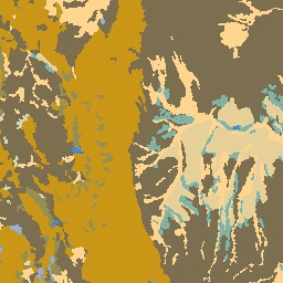
مجموعه دادههای سنگشناسی، کلاسهایی از انواع کلی مواد مادری خاک روی سطح را ارائه میدهد. این مجموعه از هیچ DEM مشتق نشده است.
مجموعه دادههای ژئومورفولوژی، لندفرمها و فیزیوگرافی مرتبط با اکولوژی (ERGo) شرکای علوم حفاظت (CSP) حاوی دادههای دقیق و چندمقیاسی در مورد لندفرمها و الگوهای فیزیوگرافی (معروف به وجه زمین) هستند. اگرچه کاربردهای بالقوه زیادی برای این دادهها وجود دارد، هدف اصلی این دادهها، توسعه یک طبقهبندی و نقشه مرتبط با اکولوژی از لندفرمها و طبقات فیزیوگرافی بود که برای برنامهریزی سازگاری با آب و هوا مناسب باشند. از آنجا که عدم قطعیت زیادی در ارتباط با شرایط آب و هوایی آینده و حتی عدم قطعیت بیشتر در مورد پاسخهای اکولوژیکی وجود دارد، ارائه اطلاعات در مورد آنچه بعید است تغییر کند، پایه محکمی را برای مدیران فراهم میکند تا برنامههای سازگاری با آب و هوا قوی ایجاد کنند. کمیسازی این ویژگیهای چشمانداز به وضوح تصویر حساس است، بنابراین ما با توجه به وسعت و ویژگیهای یک شاخص معین، بالاترین وضوح ممکن را ارائه میدهیم.
باندها
باندها
اندازه پیکسل: ۹۰ متر (همه باندها)
| نام | اندازه پیکسل | توضیحات |
|---|---|---|
b1 | ۹۰ متر | کلاسهای سنگشناسی |
جدول کلاس b1
| ارزش | رنگ | توضیحات |
|---|---|---|
| 0 | #356eff | آب |
| ۱ | #acb6da | کربنات |
| ۳ | #d6b879 | غیر کربناته |
| ۴ | #۳۱۳۱۳۱ | نفوذی قلیایی |
| ۵ | #eda800 | باقیمانده سیلیسی |
| ۷ | #۶۱۶۱۶۱ | آتشفشانی خروجی |
| ۸ | #d6d6d6 | رسوب کوهرفتی |
| ۹ | #d0ddae | یخبندان تا خاک رس |
| ۱۰ | #b8d279 | خاک لومی یخبندان |
| ۱۱ | #d5d378 | یخبندان تا دانه درشت |
| ۱۳ | #۱۴۱۴۱۴ | رسوبات ریز دریاچه یخچالی |
| ۱۴ | #6db155 | یخزدگی سطحی (یا: زبری سطح آب ناشی از یخبندان) |
| ۱۵ | #9b6d55 | هیدریک |
| ۱۶ | #فیئیسی۹ | رسوبات بادی درشت |
| ۱۷ | #d6b879 | رسوبات بادی ریز |
| ۱۸ | #00b7ec | رسوب دریاچه شور |
| ۱۹ | #ffda90 | آبرفت و رسوبات ساحلی ریز |
| ۲۰ | #f8b28c | رسوبات ساحلی درشت |
شرایط استفاده
شرایط استفاده
نقل قولها
تئوبالد، دیام، هریسون-اطلس، دی.، موناهان، دبلیوبی، و آلبانو، سیام (2015). نقشههای مرتبط با بومشناسی از لندفرمها و تنوع فیزیوگرافی برای برنامهریزی سازگاری با آب و هوا. PloS one، 10(12)، e0143619
با موتور زمین کاوش کنید
ویرایشگر کد (جاوااسکریپت)
var dataset = ee.Image('CSP/ERGo/1_0/US/lithology');
var lithology = dataset.select('b1');
var lithologyVis = {
  min: 0.0,
  max: 20.0,
  palette: [
    '356eff', 'acb6da', 'd6b879', '313131', 'eda800', '616161', 'd6d6d6',
    'd0ddae', 'b8d279', 'd5d378', '141414', '6db155', '9b6d55', 'feeec9',
    'd6b879', '00b7ec', 'ffda90', 'f8b28c'
  ],
};
Map.setCenter(-105.8636, 40.3439, 11);
Map.addLayer(lithology, lithologyVis, 'Lithology');