- Dostępność zbioru danych
- 2006-01-24T00:00:00Z–2011-05-13T00:00:00Z
- Dostawca zbioru danych
- Conservation Science Partners
- Tagi
Opis
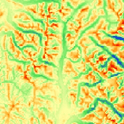
Wskaźnik mTPI odróżnia grzbiety od dolin. Jest on obliczany na podstawie danych o wysokości nad poziomem morza w każdej lokalizacji, od których odejmowana jest średnia wysokość nad poziomem morza w danej okolicy. mTPI wykorzystuje ruchome okna o promieniach (w km): 115,8, 89,9, 35,5, 13,1, 5,6, 2,8 i 1,2. Jest on oparty na modelu DEM NED o rozdzielczości 10 m od USGS (dostępnym w EE jako USGS/NED).
Zbiory danych Conservation Science Partners (CSP) Ecologically Relevant Geomorphology (ERGo), Landforms and Physiography zawierają szczegółowe dane wieloskalowe dotyczące form terenu i wzorców fizjograficznych (czyli aspektów terenu). Chociaż dane te można wykorzystać na wiele sposobów, pierwotnym celem ich gromadzenia było opracowanie istotnej z ekologicznego punktu widzenia klasyfikacji i mapy form terenu oraz klas fizjograficznych, które nadają się do planowania adaptacji do zmian klimatu. Przyszłe warunki klimatyczne są obarczone dużą niepewnością, a reakcje ekologiczne – jeszcze większą. Dlatego informacje o tym, co prawdopodobnie się nie zmieni, stanowią solidną podstawę do opracowywania przez menedżerów solidnych planów adaptacji do zmian klimatu. Kwantyfikacja tych cech krajobrazu jest zależna od rozdzielczości, dlatego podajemy najwyższą możliwą rozdzielczość, biorąc pod uwagę zakres i charakterystykę danego indeksu.
Pasma
Pasma
Rozmiar piksela: 270 m (wszystkie pasma)
| Nazwa | Jednostki | Min. | Maks. | Rozmiar piksela | Opis |
|---|---|---|---|---|---|
elevation |
m | -378 | 493 | 270 metrów | Wartości mTPI pochodzące z danych NED, które wahają się od ujemnych (doliny) do dodatnich (grzbiety) |
Warunki korzystania z usługi
Warunki korzystania z usługi
Cytaty
Theobald, D. M., Harrison-Atlas, D., Monahan, W. B., & Albano, C. M. (2015). Mapy form terenu i różnorodności fizjograficznej istotne z ekologicznego punktu widzenia na potrzeby planowania adaptacji do zmian klimatu. PloS one, 10(12), e0143619
Odkrywaj za pomocą Earth Engine
Edytor kodu (JavaScript)
var dataset = ee.Image('CSP/ERGo/1_0/US/mTPI');
var usMtpi = dataset.select('elevation');
var usMtpiVis = {
  min: -200.0,
  max: 200.0,
  palette: ['0b1eff', '4be450', 'fffca4', 'ffa011', 'ff0000'],
};
Map.setCenter(-105.8636, 40.3439, 11);
Map.addLayer(usMtpi, usMtpiVis, 'US mTPI');