- Dataset Availability
- 2023-11-14T00:00:00Z–2023-11-14T00:00:00Z
- Dataset Provider
- Environmental Defense Fund - MethaneSAT
- Earth Engine Snippet
-
FeatureCollection
ee.FeatureCollection("EDF/OGIM/OGIM_v2-4_RF06_RF08") -
FeatureView
ui.Map.FeatureViewLayer("EDF/OGIM/OGIM_v2-4_RF06_RF08_FeatureView") - Tags
Description
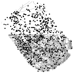
This dataset provides the locations of oil and gas (O&G) related infrastructure within two key O&G producing regions in the United States: the Delaware sub-basin of the Permian Basin in western Texas and southern New Mexico, and the Uinta Basin in Utah.
The Oil and Gas Infrastructure Mapping (OGIM) database is a project developed by the Environmental Defense Fund (EDF) and MethaneSAT LLC, a wholly-owned subsidiary of EDF. The primary objective of developing a standardized O&G infrastructure database such as OGIM is to support MethaneSAT's emission quantification, source characterization, and other scientific- or advocacy-relevant analyses of methane emissions from the oil and gas sector. The OGIM database is developed based on the acquisition, analysis, and quality assurance of publicly available geospatial data sources of O&G facilities, which are combined within one standard data schema and coordinate reference system.
This dataset contains the spatial locations of the following types of infrastructure assets:
- oil and gas wells,
- natural gas compressor stations,
- gathering and processing facilities,
- petroleum terminals,
- oil and gas pipelines,
- satellite detections of oil and gas flares,
- and "other" oil and gas related infrastructure, such as metering stations.
Records in the OGIM are consolidated from numerous publicly-available governmental and academic sources, including:
- Homeland Infrastructure Foundation-Level Data (HIFLD)
- EPA Facility Level Information on Greenhouse Gases Tool (FLIGHT)
- Texas Railroad Commission (RRC)
- New Mexico Energy Minerals, and Natural Resources Department (EMNRD)
- Utah Geospatial Resource Center (UGRC)
- Earth Observation Group (EOG) at the Colorado School of Mines
- Marchese et al, 2015
The O&G facilities in this dataset are spatially coincident with the extent of MethaneAIR measurements taken on 8 August 2021 (research flight RF06) over the Permian Basin and 11 August 2021 (research flight RF08) over the Uinta Basin. MethaneAIR is an airborne precursor of the MethaneSAT satellite mission, managed by MethaneSAT LLC. Only O&G facilities found within the RF06 or RF08 region of interest are included in this data release.
Important notes about the attributes associated with these facility locations:
Missing values (i.e., values missing or not reported by the original data source) are handled by assigning "N/A" to string attributes, -999 to numerical attributes, and a generic date of "1900-01-01" to date/datetime attributes.
Facility operator names have not been altered in any way from the original source of data and are assumed to be accurate as of the original source's publication date.
For more information about the OGIM database, including methods used in its development and key applications of the database, please refer to the recent publication by Omara et al, 2023.
Contact the data provider for more information about the project at this link: https://www.methanesat.org/contact/
Table Schema
Table Schema
| Name | Type | Description |
|---|---|---|
| CATEGORY | STRING | Category of O&G infrastructure to which the facility belongs. Values:
|
| FAC_ID | STRING | Unique ID used by the original source agency to identify the facility. |
| FAC_NAME | STRING | Name of the facility. |
| FAC_TYPE | STRING | Detailed information on type of facility. |
| OGIM_ID | INT | Unique identifier for each facility in the geopackage. Values do not repeat across infrastructure categories. |
| OGIM_STATUS | STRING | Standardized version of the facility status reported by the original data source. The original statuses were binned into one of 12 categories defined by EDF. |
| OPERATOR | STRING | Name of the facility's operator, according to the original source at time of publication. |
| SRC_DATE | STRING | Original publication date of the data source from which the record was acquired, in YYYY-MM-DD format. |
| SRC_REF_ID | INT | ID number linking the record to its corresponding original data source. For more information, refer to the "Data_Catalog" table in the GeoPackage that accompanies Omara et al (2023). Values:
|
| STATE_PROV | STRING | State or province in which the facility resides. Values:
|
Terms of Use
Terms of Use
Citations
Omara, M., Gautam, R., O'Brien, M., Himmelberger, A., Franco, A., Meisenhelder, K., Hauser, G., Lyon, D., Chulakadaba, A., Miller, C. and Franklin, J., 2023. Developing a spatially explicit global oil and gas infrastructure database for characterizing methane emission sources at high resolution. Earth System Science Data Discussions, 2023, pp.1-35. doi:10.5194/essd-15-3761-2023,
DOIs
Explore with Earth Engine
Code Editor (JavaScript)
var dataset = ee.FeatureCollection("EDF/OGIM/OGIM_v2-4_RF06_RF08");

var datasetVis = dataset.style({
  color: 'black',
  pointSize: 3,
});

// Center on one of the two available areas of interests.
// Map.setCenter(-109.6, 40, 9);
Map.setCenter(-103.71, 31.96, 9);
Map.setOptions("SATELLITE");
Map.addLayer(datasetVis, {}, 'oil and gas infrastructure')
Visualize as a FeatureView
A FeatureView is a view-only, accelerated representation of a
FeatureCollection. For more details, visit the
FeatureView documentation.
Code Editor (JavaScript)
var fvLayer = ui.Map.FeatureViewLayer('EDF/OGIM/OGIM_v2-4_RF06_RF08_FeatureView');

var visParams = {
  pointSize: 3,
  color: {
    property: 'CATEGORY',
    categories: [
      ['GATHERING AND PROCESSING', 'red'],
      ['NATURAL GAS COMPRESSOR STATION', 'green'],
      ['NATURAL GAS FLARING DETECTIONS', 'blue'],
      ['OIL AND NATURAL GAS WELLS', 'purple'],
    ],
    defaultValue: 'white'
  }
};

fvLayer.setVisParams(visParams);
fvLayer.setName('Oil and gas infrastructure database');

// Center on one of the two available areas of interests.
Map.setCenter(-109.6, 40, 9);
// Map.setCenter(-103.71, 31.96, 9);
Map.setOptions("SATELLITE");
Map.add(fvLayer);