- 数据集可用时间
- 2024-05-15T00:00:00Z–2024-05-15T00:00:00Z
- 数据集生产者
- 美国环保基金会 - MethaneSAT
- 标签
说明
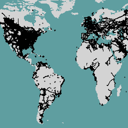
此数据集提供全球石油和天然气 (O&G) 相关基础设施的位置信息。
石油和天然气基础设施地图 (OGIM) 数据库是由环境保卫基金 (EDF) 和 EDF 的全资子公司 MethaneSAT LLC 开发的项目。开发 OGIM 等标准化石油和天然气基础设施数据库的主要目的是支持 MethaneSAT 对石油和天然气行业的甲烷排放进行量化、来源特征分析,以及其他与科学或倡导相关的分析。OGIM 数据库基于石油和天然气设施的公开地理空间数据源的采集、分析和质量保证而开发,这些数据源在一个标准数据架构和坐标参考系中组合在一起。
此数据集包含以下类型的基础设施资产的空间位置:
- 油气井,
- 石油和天然气管道,
- 天然气压缩机站,
- 收集和处理设施,
- 坦克电池,
- 海上平台、
- 液化天然气 (LNG) 设施,
- 原油炼油厂,
- 石油码头,
- 注入和处置设施,
- 设备和组件位置,
- 卫星检测到的油气火炬,
- 以及“其他”与石油和天然气相关的基础设施,例如计量站
OGIM 中的记录整合自众多公开的政府和学术来源。您可以在 OGIM_v2.5.1_Data_Source_References.pdf 文档中找到此来源列表。如需详细了解每个来源,请参阅 Omara 等人 (2023) 随附的“Data_Catalog”表格。
与这些设施位置相关联的属性方面的重要说明:
对于缺失值(即原始数据源中缺失或未报告的值),系统会为字符串属性分配“不适用”,为数值属性分配 -999,为日期/日期时间属性分配通用日期“1900-01-01”。
设施运营商名称未以任何方式更改,并且假定在原始数据源的发布日期时是准确的。
如需详细了解 OGIM 数据库(包括其开发中采用的方法和数据库的主要应用),请参阅 Omara 等人于 2023 年发表的最新出版物。
如需详细了解此项目,请访问以下链接与数据提供方联系: https://www.methanesat.org/contact/
此数据集将就地更新为新版本。
表格结构
表格结构
| 名称 | 类型 | 说明 |
|---|---|---|
| 类别 | STRING | 设施所属的石油和天然气基础设施类别。 值:
|
| OGIM_ID | INT | 数据集中每个医疗机构的唯一标识符。值在各个基础设施类别中不会重复。 |
| SRC_DATE | STRING | 获取相应记录的数据源的原始发布日期,格式为 YYYY-MM-DD。 |
| SRC_REF_ID | INT | 将记录与其对应的原始数据源相关联的 ID 编号。如需查找给定 SRC_REF_ID 值的引用,请参阅数据源参考列表或随 Omara 等人 (2023) 提供的 GeoPackage 中的“Data_Catalog”表。 |
| 国家/地区 | STRING | 相应记录所在的国家/地区。如果可能,国家/地区名称应与联合国会员国列表一致。 如果功能位于多个国家/地区,则 COUNTRY 字段包含这些国家/地区的逗号分隔列表,并按字母顺序排列。 |
| STATE_PROV | STRING | 相应设施所在的州或省。 |
| FAC_ID | STRING | 原始来源机构用于标识设施的唯一 ID。 |
| FAC_NAME | STRING | 设施的名称。 |
| FAC_STATUS | STRING | 基础设施资产的运营状态,根据原始来源,例如“ACTIVE”“SUSPENDED”“TEMPORARILY CLOSED”。 FAC_STATUS 为“N/A”时,不能假定为有效或无效。 |
| FAC_TYPE | STRING | 有关设施类型的详细信息。 |
| OGIM_STATUS | STRING | 原始数据源报告的设施状态的标准化版本。原始状态被归入 EDF 定义的 12 个类别之一。 |
| OPERATOR | STRING | 根据发布时的原始来源,设施运营商的名称。 |
使用条款
使用条款
引用
Omara, M.、Gautam, R., O'Brien, M.、Himmelberger, A.,Franco, A.、 Meisenhelder, K.、Hauser, G.、Lyon, D.、Chulakadaba, A.、Miller, C. 和 Franklin, J.,2023 年。开发一个空间显式全球石油和天然气基础设施数据库,以高分辨率表征甲烷排放源。《地球系统科学数据讨论》,2023 年,第 1-35 页。 doi:10.5194/essd-15-3761-2023,
DOI
通过 Earth Engine 探索
代码编辑器 (JavaScript)
var dataset = ee.FeatureCollection("EDF/OGIM/current");

var datasetVis = dataset.style({
  color: 'black',
  fillColor: 'yellow',
  pointSize: 2,
  width: 0.5
});

Map.setCenter(-96, 40, 4);
Map.setOptions("SATELLITE");
Map.addLayer(datasetVis, {}, 'oil and gas infrastructure');
以 FeatureView 形式直观呈现
FeatureView 是 FeatureCollection 的只读加速表示形式。如需了解详情,请访问
FeatureView 文档。
代码编辑器 (JavaScript)
var fvLayer = ui.Map.FeatureViewLayer('EDF/OGIM/current_FeatureView');

var visParams = {
  pointSize: 2,
  width: 0.5,
  color: {
    property: 'CATEGORY',
    categories: [
      ['GATHERING AND PROCESSING', 'red'],
      ['NATURAL GAS COMPRESSOR STATION', 'green'],
      ['NATURAL GAS FLARING DETECTIONS', 'blue'],
      ['OIL AND NATURAL GAS WELLS', 'purple'],
      ['OFFSHORE PLATFORMS', 'yellow']
    ],
    defaultValue: 'white'
  }
};

fvLayer.setVisParams(visParams);
fvLayer.setName('Oil and gas infrastructure database');

Map.setCenter(-96, 40, 4);
Map.setOptions("SATELLITE");
Map.add(fvLayer);