Page Summary
-
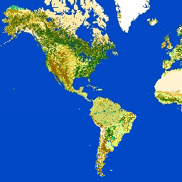
GlobCover 2009 is a global land cover map created from ENVISAT's MERIS data with approximately 300-meter spatial resolution.
-
The dataset is available for the period of 2009-01-01 to 2010-01-01 and provided by ESA.
-
The map includes a 'landcover' band with 22 defined land cover classes and a 'qa' quality band.
-
Use of the GlobCover products is permitted for educational and scientific purposes with appropriate credit to ESA and UCLouvain.
- Dataset Availability
- 2009-01-01T00:00:00Z–2010-01-01T00:00:00Z
- Dataset Provider
- ESA
- Tags
Description
GlobCover 2009 is a global land cover map based on ENVISAT's Medium Resolution Imaging Spectrometer (MERIS) Level 1B data acquired in full resolution mode with a spatial resolution of approximately 300 meters.
Bands
Pixel Size
300 meters
Bands
| Name | Pixel Size | Description | |||||||||||||||||||||||||||||||||||||||||||||||||||||||||||||||||||||||||||||||||||||||||||||||||
|---|---|---|---|---|---|---|---|---|---|---|---|---|---|---|---|---|---|---|---|---|---|---|---|---|---|---|---|---|---|---|---|---|---|---|---|---|---|---|---|---|---|---|---|---|---|---|---|---|---|---|---|---|---|---|---|---|---|---|---|---|---|---|---|---|---|---|---|---|---|---|---|---|---|---|---|---|---|---|---|---|---|---|---|---|---|---|---|---|---|---|---|---|---|---|---|---|---|---|---|
landcover |
meters | The land cover map is derived by an automatic and regionally-tuned classification of a time series of global MERIS FR mosaics for the year 2009. The global land cover map counts 22 land cover classes defined with the United Nations (UN) Land Cover Classification System (LCCS). |
|||||||||||||||||||||||||||||||||||||||||||||||||||||||||||||||||||||||||||||||||||||||||||||||||
qa |
meters | Binary quality band indicating whether the reference dataset has been used instead of the output of the GlobCover classification scheme. |
|||||||||||||||||||||||||||||||||||||||||||||||||||||||||||||||||||||||||||||||||||||||||||||||||
landcover Class Table
| Value | Color | Description |
|---|---|---|
| 11 | #aaefef | Post-flooding or irrigated croplands |
| 14 | #ffff63 | Rainfed croplands |
| 20 | #dcef63 | Mosaic cropland (50-70%) / vegetation (grassland, shrubland, forest) (20-50%) |
| 30 | #cdcd64 | Mosaic vegetation (grassland, shrubland, forest) (50-70%) / cropland (20-50%) |
| 40 | #006300 | Closed to open (>15%) broadleaved evergreen and/or semi-deciduous forest (>5m) |
| 50 | #009f00 | Closed (>40%) broadleaved deciduous forest (>5m) |
| 60 | #aac700 | Open (15-40%) broadleaved deciduous forest (>5m) |
| 70 | #003b00 | Closed (>40%) needleleaved evergreen forest (>5m) |
| 90 | #286300 | Open (15-40%) needleleaved deciduous or evergreen forest (>5m) |
| 100 | #788300 | Closed to open (>15%) mixed broadleaved and needleleaved forest (>5m) |
| 110 | #8d9f00 | Mosaic forest-shrubland (50-70%) / grassland (20-50%) |
| 120 | #bd9500 | Mosaic grassland (50-70%) / forest-shrubland (20-50%) |
| 130 | #956300 | Closed to open (>15%) shrubland (<5m) |
| 140 | #ffb431 | Closed to open (>15%) grassland |
| 150 | #ffebae | Sparse (>15%) vegetation (woody vegetation, shrubs, grassland) |
| 160 | #00785a | Closed (>40%) broadleaved forest regularly flooded - Fresh water |
| 170 | #009578 | Closed (>40%) broadleaved semi-deciduous and/or evergreen forest regularly flooded - saline water |
| 180 | #00dc83 | Closed to open (>15%) vegetation (grassland, shrubland, woody vegetation) on regularly flooded or waterlogged soil - fresh, brackish or saline water |
| 190 | #c31300 | Artificial surfaces and associated areas (urban areas >50%) GLOBCOVER 2009 |
| 200 | #fff5d6 | Bare areas |
| 210 | #0046c7 | Water bodies |
| 220 | #ffffff | Permanent snow and ice |
| 230 | #743411 | Unclassified |
Terms of Use
Terms of Use
The GlobCover products have been processed by ESA and by the Université Catholique de Louvain. They are made available to the public by ESA. You may use the GlobCover land cover map for educational and/or scientific purposes, without any fee on the condition that you credit ESA and the Université Catholique de Louvain as the source of the GlobCover products.
Citations
ESA 2010 and UCLouvain. http://due.esrin.esa.int/page_globcover.php
Explore with Earth Engine
Code Editor (JavaScript)
var dataset = ee.Image('ESA/GLOBCOVER_L4_200901_200912_V2_3');
var landcover = dataset.select('landcover');
Map.setCenter(-88.6, 26.4, 3);
Map.addLayer(landcover, {}, 'Landcover');