-
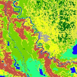
哥白尼 CORINE 土地覆盖
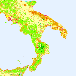
CORINE(环境信息协调)土地覆盖 (CLC) 清单于 1985 年启动,旨在标准化欧洲土地数据收集,以支持制定环境政策。该项目由欧洲环境署 (EEA) 在欧盟… 哥白尼 欧洲环境署 欧洲航天局 欧盟 土地覆盖 土地利用和土地覆盖 -
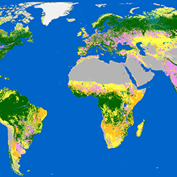
哥白尼全球土地覆盖层:CGLS-LC100 Collection 3

哥白尼全球陆地服务 (CGLS) 被指定为陆地服务的一个组件,用于运行一个多用途服务组件,该组件可提供一系列关于全球陆地表面状况和演变的生物地球物理产品。… 的动态土地覆盖地图 哥白尼 欧洲环境署 欧洲航天局 欧盟 土地覆盖 土地利用和土地覆盖 -
科特迪瓦 BNETD 2020 年土地覆盖地图

科特迪瓦 BNETD 2020 年土地覆被地图由科特迪瓦政府通过国家机构国家研究办公室技术与发展中心 (BNETD-CIGN) 制作,并获得了欧盟的技术和资金支持。方法… 分类 森林砍伐 森林 土地覆盖 土地利用-土地覆盖 -
DESS China Terrace Map v1

此数据集是 2018 年中国梯田地图,分辨率为 30 米。该模型基于 Google Earth Engine 平台,通过使用多源和多时态数据进行监督像素级分类来开发。总体准确率和 Kappa 系数分别达到 94% 和 0.72。第一个… 农业 土地覆盖 土地利用 土地利用和土地覆盖 清华 -
Dynamic World V1

Dynamic World 是一个分辨率为 10 米的近乎实时 (NRT) 土地使用/土地覆盖 (LULC) 数据集,其中包含九个类别的类别概率和标签信息。Dynamic World 预测数据覆盖从 2015 年 6 月 27 日至今的 Sentinel-2 L1C 数据集。Sentinel-2 的重访频率为 2-5 天… global google landcover landuse landuse-landcover nrt -
ESA WorldCover 10 米 v100
欧洲空间局 (ESA) WorldCover 10 m 2020 产品基于 Sentinel-1 和 Sentinel-2 数据,提供 2020 年全球土地覆被地图,分辨率为 10 米。WorldCover 产品包含 11 种地表覆被类别,在 … 框架下生成 esa landcover landuse landuse-landcover sentinel1-derived sentinel2-derived -
ESA WorldCover 10m v200

欧洲空间局 (ESA) WorldCover 10 m 2021 产品基于 Sentinel-1 和 Sentinel-2 数据,提供 2021 年全球土地覆被地图,分辨率为 10 米。WorldCover 产品包含 11 种地表覆被类别,在 … 框架下生成 esa landcover landuse landuse-landcover sentinel1-derived sentinel2-derived -
Farmscapes 2020
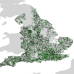
Farmscapes 2020 数据集提供了高分辨率 (25cm) 的概率地图,其中包含英格兰农业景观中的三种关键半自然特征:树篱、林地和石墙。此数据集是与牛津大学 Leverhulme Centre for Nature Recovery 合作开发的,可作为应用的基础数据… 生物多样性 气候 保护 生态连通性 森林 土地利用和土地覆盖 -
Farmscapes 2020 矢量化

这是 Farmscapes 2020 光栅数据集的矢量化版本。该数据集提供了多边形几何图形,用于表示英格兰农业景观中的精细半自然景观特征(具体而言是树篱、林地和石墙)。此数据集是与 Oxford Leverhulme Centre for Nature Recovery 合作开发的,旨在… 生物多样性 气候 保护 生态连通性 森林 土地利用和土地覆盖 -
GPW 草地年主导类 v1

此数据集提供 2000 年至 2022 年全球草地(人工和天然/半天然)年度主要类别地图,空间分辨率为 30 米。此地图由 Land & Carbon Lab Global Pasture Watch 计划制作,其中显示的草地范围包括任何地表覆盖类型,只要其中包含至少 … 全球 全球牧场监测 土地 土地覆盖 土地利用 土地利用和土地覆盖 -
GPW 耕地草地年概率 v1

此数据集提供 2000 年至 2022 年全球人工草地年度概率地图,空间分辨率为 30 米。此地图由 Land & Carbon Lab Global Pasture Watch 计划制作,其中显示的草地范围包括任何土地覆盖类型,这些类型至少包含 30% 的干… 全球 全球牧场监测 土地 土地覆盖 土地利用 土地利用和土地覆盖 -
GPW 天然/半天然草地的年度概率 v1

此数据集提供 2000 年至 2022 年全球天然/半天然草地年度概率地图,空间分辨率为 30 米。此地图由 Land & Carbon Lab Global Pasture Watch 计划制作,其中显示的草地范围包括任何土地覆盖类型,这些类型至少包含 30% 的干… 全球 全球牧场监测 土地 土地覆盖 土地利用 土地利用和土地覆盖 -
GlobCover:全球土地覆盖地图

GlobCover 2009 是一张全球土地覆被地图,基于 ENVISAT 的中分辨率成像光谱仪 (MERIS) 在全分辨率模式下获取的 1B 级数据生成,空间分辨率约为 300 米。 esa landcover landuse-landcover -
全球红树林面积年变化图(1984 年至 2023 年)

CGMD-Extent30(连续全球红树林动态 - 分辨率为 30 米的年度红树林范围)数据集提供 1984 年至 2023 年的全球年度红树林范围。该数据集以单个 Earth Engine FeatureCollection 的形式分发,其中每个要素代表特定年份的红树林多边形地图。数据集… 年度 沿海 森林生物质 全球 基于 Landsat 的 土地利用和土地覆盖 -
局地气候带全球地图,最新版本

自 2012 年推出局地气候带 (LCZ) 以来,其已成为表征城市景观的新标准,提供了一种综合考虑微观尺度土地覆盖及相关物理属性的整体分类方法。这份全球局地气候带地图代表 2018 基准年,像元大小为 100m … climate landcover landuse-landcover urban -
Google 基于 Landsat 的全球 CCDC 分段(1999 年至 2019 年)

此集合包含对 20 年的 Landsat 地表反射率数据运行持续变化检测和分类 (CCDC) 算法后预先计算的结果。CCDC 是一种断点查找算法,它使用谐波拟合和动态 RMSE 阈值来检测时间序列数据中的断点。… change-detection google landcover landsat-derived landuse landuse-landcover -
伊朗土地覆被地图 v1 13 类(2017 年)

伊朗全境土地覆盖地图是通过在 Google Earth Engine 云平台中处理 Sentinel 影像生成的。为此,我们处理了 2,500 多张 Sentinel-1 影像和 11,000 多张 Sentinel-2 影像,以生成 2017 年的单个镶嵌数据集。然后,基于对象的随机数生成器… landcover landuse-landcover -
LUCAS Copernicus(带属性的多边形,2018 年)V1

欧盟 (EU) 的土地利用/覆盖面积框架调查 (LUCAS) 旨在提供统计信息。该计划每三年开展一次原位地表覆盖和土地利用数据收集工作,覆盖整个欧盟地区。LUCAS 收集有关土地覆被和…的信息 哥白尼 欧盟 jrc 土地覆盖 土地利用 土地利用和土地覆盖 -
LUCAS Harmonized(理论位置,2006-2018 年)V1
欧盟 (EU) 的土地利用/覆盖面积框架调查 (LUCAS) 旨在提供统计信息。该计划每三年开展一次原位地表覆盖和土地利用数据收集工作,覆盖整个欧盟地区。LUCAS 收集有关土地覆被和…的信息 eu jrc landcover landuse landuse-landcover lucas -
LUCAS THLOC(具有属性的点,2022 年)V1

欧盟 (EU) 的土地利用/覆盖面积框架调查 (LUCAS) 旨在提供统计信息。该计划每三年开展一次原位地表覆盖和土地利用数据收集工作,覆盖整个欧盟地区。LUCAS 收集有关土地覆被和…的信息 eu jrc landcover landuse landuse-landcover lucas -
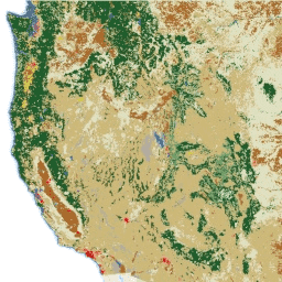
2020 年北美土地覆盖情况(30 米分辨率)

2020 年北美土地覆盖 30 米数据集是北美土地变化监测系统 (NALCMS) 的一部分,该系统是加拿大自然资源部、美国地质调查局和三个墨西哥组织(包括国家统计和地理研究所)之间的三边合作项目。 landcover landsat landuse-landcover nlcd reflectance -
MCD12C1.061 MODIS 土地覆盖类型年度全球 0.05 度 CMG

Terra 和 Aqua 组合的中等分辨率成像光谱辐射计 (MODIS) 土地覆盖气候模型网格 (CMG) (MCD12C1) 版本 6.1 数据产品提供了平铺 MCD12Q1 版本 6.1 数据产品的空间聚合和重新投影版本。国际地圈-生物圈计划 (IGBP) 地图,… 大学 landcover landuse-landcover modis nasa usgs yearly -
MCD12Q1.061 MODIS 土地覆被类型年度全球 500 米
Terra 和 Aqua 组合的中等分辨率成像光谱辐射计 (MODIS) 土地覆盖类型 (MCD12Q1) 版本 6.1 数据产品以年为间隔提供全球土地覆盖类型。MCD12Q1 版本 6.1 数据产品是使用 MODIS Terra 和 Aqua 反射率数据的监督分类得出的。土地… landcover landuse-landcover modis nasa usgs yearly -
MCD12Q2.006 土地覆盖动态年度全球 500 米

Terra 和 Aqua 卫星组合的中等分辨率成像光谱辐射计 (MODIS) 土地覆盖动态 (MCD12Q2) 版本 6.1 数据产品以年为间隔提供全球地表物候指标。MCD12Q2 版本 6.1 数据产品源自双波段增强型植被指数 (EVI2) 的时间序列… EVI 全球 土地利用和土地覆盖 MODIS 绿度起始 物候 -
MOD44B.061 Terra 植被连续场年度全球 250 米

Terra MODIS 植被连续场 (VCF) 产品是全球地表植被覆盖估计值的亚像素级表示。该模型旨在以基本植被特征的比例来连续表示地球陆地表面,它提供了三种地表覆盖成分的梯度:树木覆盖率百分比、… 年度 地球物理 全球 土地利用和土地覆盖 MODIS NASA -
MapBiomas 土地利用和土地覆被 - 玻利维亚 V1.0

MapBiomas 玻利维亚土地利用和土地覆盖 (LULC) 数据集由 MapBiomas 项目每年使用 Landsat 卫星图像和机器学习分类技术生成。该数据集提供分辨率为 30 米的连贯年度土地覆盖地图,涵盖 1985 年至 2024 年期间。玻利维亚的… landsat-derived landuse-landcover mapbiomas-public publisher-dataset -
MapBiomas 土地利用和土地覆盖 - 巴西 V1.0

MapBiomas 巴西土地利用和土地覆盖 (LULC) 数据集由 MapBiomas 项目每年使用 Landsat 卫星图像和机器学习分类技术生成。该数据集提供分辨率为 30 米的连贯且主题详细的地图,涵盖数十年,每年都会更新。每个图片… landsat-derived landuse-landcover mapbiomas-public publisher-dataset -
MapBiomas 土地利用和土地覆盖 - 厄瓜多尔 V1.0

厄瓜多尔的 MapBiomas 土地使用和土地覆盖 (LULC) 数据集由 MapBiomas 项目每年使用 Landsat 卫星图像和机器学习分类技术生成。该数据集提供分辨率为 30 米的连贯年度土地覆盖地图,涵盖 1985 年至 2024 年期间。厄瓜多尔的… landsat-derived landuse-landcover mapbiomas-public publisher-dataset -
NLCD 2019:美国地质调查局国家土地覆盖数据库,2019 年发布
NLCD(美国国家土地覆盖数据库)是一个基于 Landsat 的 30 米土地覆盖数据库,涵盖 8 个时间段(2001 年、2004 年、2006 年、2008 年、2011 年、2013 年、2016 年和 2019 年)。您还可以在此处找到 2021 年的第九个周期。这些图片依赖于不透水性数据层来显示城市… blm landcover landuse-landcover mrlc nlcd usgs -
NLCD 2021:美国地质调查局国家土地覆盖数据库,2021 年发布
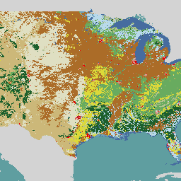
美国地质调查局 (USGS) 与多个联邦机构合作,现已开发并发布了七个国家土地覆盖数据库 (NLCD) 产品:NLCD 1992、2001、2006、2011、2016、2019 和 2021。自 2016 年发布以来,地表覆盖产品每隔 2-3 年创建一次… blm landcover landuse-landcover mrlc nlcd usgs -
牛津 MAP:疟疾地图集项目分数国际地圈-生物圈计划土地覆盖

此地表覆盖产品的基础数据集是 MODIS 年度地表覆盖产品 (MCD12Q1) 中的 IGBP 层。此数据从其类别格式(分辨率约为 500 米)转换为分数产品,表示输出的整数百分比 (0-100) … landcover landuse-landcover map -
RCMAP 草地分量时间序列(1985 年至 2023 年),版本 06

“RCMAP(草地状况监测评估和预测)数据集使用 1985 年至 2023 年的 Landsat 影像,量化了北美西部草地组成部分的覆盖百分比。RCMAP 产品套件包含 10 个分数组件:一年生草本、裸地、草本、凋落物、非山艾灌木、多年生草本、山艾灌木等。 climate-change disturbance landsat-derived landuse-landcover nlcd rangeland -
RCMAP 草地趋势年(1985-2023 年),v06

此合集包含 1985 年至 2023 年的 RCMAP 年度产品。RCMAP(牧草地状况监测评估和预测)数据集使用 1985 年至 2023 年的 Landsat 影像,量化了北美西部牧草地组成部分的覆盖百分比。RCMAP 产品套件包含 10 个分数组件:年限、… climate-change disturbance landsat-derived landuse-landcover nlcd rangeland -
RCMAP 草地分量时间序列趋势(1985 年至 2023 年),版本 06

RCMAP(牧草地状况监测评估和预测)数据集使用 1985 年至 2023 年的 Landsat 影像,量化了北美西部牧草地组成部分的覆盖百分比。RCMAP 产品套件包含 10 个分数组件:一年生草本、裸地、草本、凋落物、非山艾灌木、多年生草本、山艾灌木等。 climate-change disturbance landsat-derived landuse-landcover nlcd rangeland -
SBTN Natural Lands Map v1
SBTN 自然土地地图 v1 是一张 2020 年的自然和非自然土地覆盖基准地图,旨在供企业在制定基于科学的自然目标时使用,特别是 SBTN 土地目标 1:不转换自然生态系统。“自然”和“非自然”的定义改编自… 生态系统 landcover landuse-landcover wri -
SBTN Natural Lands Map v1.1
SBTN 自然土地地图 v1.1 是一张 2020 年的自然和非自然土地覆盖基准地图,旨在供企业在制定基于科学的自然目标时使用,特别是 SBTN 土地目标 1:不转换自然生态系统。“自然”和“非自然”的定义改编自… 生态系统 landcover landuse-landcover wri -
TUBerlin/BigEarthNet/v1

BigEarthNet 是一个全新的大规模 Sentinel-2 基准归档,包含 590,326 个 Sentinel-2 图像块。为了构建 BigEarthNet,我们于 2017 年 6 月至 2018 年 5 月期间在欧洲的 10 个国家/地区(奥地利、比利时、芬兰、爱尔兰、科索沃、立陶宛、卢森堡、葡萄牙、塞尔维亚、瑞士)获取了 125 个 Sentinel-2 地块。所有… 哥白尼 土地利用和土地覆盖 Sentinel -
USFS Landscape Change Monitoring System v2025-11(美国大陆和美国境外)

此产品是景观变化监测系统 (LCMS) 数据套件的一部分。它显示了每个年份的 LCMS 建模变化、土地覆盖和/或土地利用类别,覆盖了美国本土 (CONUS) 以及 CONUS 以外的地区 (OCONUS),包括阿拉斯加 (AK)、波多黎各… change-detection forest gtac gtac-data-publish landcover landuse -
美国林务局树冠覆盖率 v2025-6(CONUS 和 OCONUS)

树冠覆盖率 (TCC) 数据套件由美国农业部林务局 (USFS) 制作,是基于遥感的年度地图输出,涵盖 1985 年至 2025 年。这些数据支持美国地质调查局 (USGS) 管理的国家土地覆盖数据库 (NLCD) 项目,… 森林 gtac gtac-data-publish landuse-landcover publisher-dataset redcastle-resources
Datasets tagged landuse-landcover in Earth Engine
[null,null,[],[],[]]