-
CSP gHM:Global Human Modification

全球人类改造数据集 (gHM) 提供全球陆地人类改造的累积度量,分辨率为 1 平方公里。gHM 值的范围为 0.0-1.0,计算方式为估计给定位置(像素)的修改比例、估计的强度… csp fragmentation human-modification landcover landscape-gradient population -
加拿大 AAFC 年度作物库存

自 2009 年起,加拿大农业及农业食品部 (AAFC) 科学技术分部 (STB) 的地球观测团队开始生成年度作物类型数字地图。该研究侧重于 2009 年和 2010 年的草原省份,采用基于决策树 (DT) 的方法… 农业 加拿大 农作物 地表覆盖 -
哥白尼 CORINE 土地覆盖
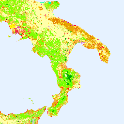
CORINE(环境信息协调)土地覆盖 (CLC) 清单于 1985 年启动,旨在标准化欧洲土地数据收集,以支持制定环境政策。该项目由欧洲环境署 (EEA) 在欧盟… 哥白尼 欧洲环境署 欧洲航天局 欧盟 土地覆盖 土地利用和土地覆盖 -
哥白尼全球土地覆盖层:CGLS-LC100 Collection 3

哥白尼全球陆地服务 (CGLS) 被指定为陆地服务的一个组件,用于运行一个多用途服务组件,该组件可提供一系列关于全球陆地表面状况和演变的生物地球物理产品。… 的动态土地覆盖地图 哥白尼 欧洲环境署 欧洲航天局 欧盟 土地覆盖 土地利用和土地覆盖 -
科特迪瓦 BNETD 2020 年土地覆盖地图

科特迪瓦 BNETD 2020 年土地覆被地图由科特迪瓦政府通过国家机构国家研究办公室技术与发展中心 (BNETD-CIGN) 制作,并获得了欧盟的技术和资金支持。方法… 分类 森林砍伐 森林 土地覆盖 土地利用-土地覆盖 -
DESS China Terrace Map v1

此数据集是 2018 年中国梯田地图,分辨率为 30 米。该模型基于 Google Earth Engine 平台,通过使用多源和多时态数据进行监督像素级分类来开发。总体准确率和 Kappa 系数分别达到 94% 和 0.72。第一个… 农业 土地覆盖 土地利用 土地利用和土地覆盖 清华 -
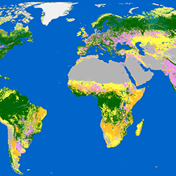
Dynamic World V1

Dynamic World 是一个分辨率为 10 米的近乎实时 (NRT) 土地使用/土地覆盖 (LULC) 数据集,其中包含九个类别的类别概率和标签信息。Dynamic World 预测数据覆盖从 2015 年 6 月 27 日至今的 Sentinel-2 L1C 数据集。Sentinel-2 的重访频率为 2-5 天… global google landcover landuse landuse-landcover nrt -
EC JRC 2020 年全球森林类型地图,V1

全球森林类型地图以空间分布的形式呈现了 2020 年原始森林、自然再生林和人工林(包括种植林)的分布情况,空间分辨率为 10 米。用于绘制这些森林类型的基本层是森林覆盖范围… eudr 森林 森林生物质 jrc 土地覆盖 原始森林 -
ESA WorldCereal 10 m v100

欧洲空间局 (ESA) WorldCereal 10 米 2021 年产品套件包含全球范围的年度和季节性作物地图及其相关置信度。这些数据是作为 ESA-WorldCereal 项目的一部分生成的。如需详细了解这些产品的内容以及用于…的方法,请参阅… 农业 哥白尼 农作物 欧洲航天局 全球 土地覆盖 -
ESA WorldCereal Active Cropland 10 m v100

欧洲空间局 (ESA) WorldCereal Active Cropland 10 m 2021 产品套件包含全球范围的季节性活跃耕地标记。这些数据是作为 ESA-WorldCereal 项目的一部分生成的。有效农田产品表示被识别为临时作物的像素是否已积极… 农业 哥白尼 农作物 欧洲航天局 全球 土地覆盖 -
ESA WorldCover 10 米 v100
欧洲空间局 (ESA) WorldCover 10 m 2020 产品基于 Sentinel-1 和 Sentinel-2 数据,提供 2020 年全球土地覆被地图,分辨率为 10 米。WorldCover 产品包含 11 种地表覆被类别,在 … 框架下生成 esa landcover landuse landuse-landcover sentinel1-derived sentinel2-derived -
ESA WorldCover 10m v200

欧洲空间局 (ESA) WorldCover 10 m 2021 产品基于 Sentinel-1 和 Sentinel-2 数据,提供 2021 年全球土地覆被地图,分辨率为 10 米。WorldCover 产品包含 11 种地表覆被类别,在 … 框架下生成 esa landcover landuse landuse-landcover sentinel1-derived sentinel2-derived -
FireCCI51:MODIS Fire_cci 烧毁面积像素产品,版本 5.1

MODIS Fire_cci 烧毁面积像素产品版本 5.1 (FireCCI51) 是一个每月更新的全球数据集,空间分辨率约为 250 米,其中包含烧毁面积信息以及辅助数据。该指数基于 MODIS 仪器在近红外 (NIR) 波段的地表反射率计算得出,… burn cci climate-change copernicus esa fire -
GFSAD1000:农田范围 1km 多研究作物掩膜,全球粮食支持分析数据

GFSAD 是 NASA 资助的项目,旨在提供高分辨率的全球农田数据及其用水量,以促进 21 世纪的全球粮食安全。GFSAD 产品是通过多传感器遥感数据(例如 Landsat、MODIS、AVHRR)、次级数据和实地地块数据得出的… 农业 农作物 土地覆盖 usgs -
GHSL:全球建成区地表 10 米分辨率 (P2023A)

此栅格数据集描绘了 2018 年从 S2 影像数据中观测到的建成区地表分布情况,以每 10 米网格单元的平方米数表示。这些数据集用于衡量:a) 总建成区面积;b) 分配给网格单元的建成区面积(… built built-environment builtup copernicus ghsl jrc -
GHSL:全球建成区地表 1975-2030 年 (P2023A)
此栅格数据集描绘了建成地表的分布情况,以每 100 米网格单元的平方米数表示。该数据集衡量了以下指标:a) 总建成区地表,以及 b) 分配给以非住宅 (NRES) 用途为主的网格单元的建成区地表。数据经过时空插值或… built built-environment builtup copernicus ghsl jrc -
GHSL:全球聚落特征(10 米)2018 年 (P2023A)
此空间栅格数据集以 10 米分辨率划定人类住区,并根据建成环境的功能和高度相关组成部分描述其内部特征。如需详细了解 GHSL 数据产品,请参阅 GHSL Data Package 2023 报告… 建筑物 建成区 建成区 哥白尼 ghsl 高度 -
GLIMS 2023:Global Land Ice Measurements From Space(2023 年全球陆地冰川太空测量)
“全球陆地冰测量计划”(GLIMS) 是一项国际计划,旨在反复调查全球约 20 万条冰川。该项目旨在创建一份全球全面的陆地冰川清单,其中包括冰川面积、几何形状、表面速度和雪线的测量数据… 冰冻圈 冰川 glims 冰 landcover nasa -
GLIMS Current:Global Land Ice Measurements From Space

“全球陆地冰测量计划”(GLIMS) 是一项国际计划,旨在反复调查全球约 20 万条冰川。该项目旨在创建一份全球全面的陆地冰川清单,其中包括冰川面积、几何形状、表面速度和雪线的测量数据… 冰冻圈 冰川 glims 冰 landcover nasa -
GPW 草地年主导类 v1

此数据集提供 2000 年至 2022 年全球草地(人工和天然/半天然)年度主要类别地图,空间分辨率为 30 米。此地图由 Land & Carbon Lab Global Pasture Watch 计划制作,其中显示的草地范围包括任何地表覆盖类型,只要其中包含至少 … 全球 全球牧场监测 土地 土地覆盖 土地利用 土地利用和土地覆盖 -
GPW 耕地草地年概率 v1

此数据集提供 2000 年至 2022 年全球人工草地年度概率地图,空间分辨率为 30 米。此地图由 Land & Carbon Lab Global Pasture Watch 计划制作,其中显示的草地范围包括任何土地覆盖类型,这些类型至少包含 30% 的干… 全球 全球牧场监测 土地 土地覆盖 土地利用 土地利用和土地覆盖 -
GPW 天然/半天然草地的年度概率 v1

此数据集提供 2000 年至 2022 年全球天然/半天然草地年度概率地图,空间分辨率为 30 米。此地图由 Land & Carbon Lab Global Pasture Watch 计划制作,其中显示的草地范围包括任何土地覆盖类型,这些类型至少包含 30% 的干… 全球 全球牧场监测 土地 土地覆盖 土地利用 土地利用和土地覆盖 -
GPW 年短植被高度 v1

此数据集提供 2000 年以来的全球植被高度中位数,空间分辨率为 30 米。该数据集由 Land & Carbon Lab 的 Global Pasture Watch 计划生成,提供自 2000 年以来全球 30 米空间分辨率的中值植被高度值(第 50 百分位)。该数据集基于… 冠层 全球 全球牧场监测 土地 土地覆盖 植物生产力 -
GPW 年未校准初级生产总值 (uGPP) v1

此数据集提供自 2000 年以来基于 EO 的全球未校准总初级生产力,空间分辨率为 30 米。当前数据集由 Land & Carbon Lab Global Pasture Watch 计划生成,提供自 2000 年以来全球范围内的总初级生产力 (GPP) 值,空间分辨率为 30 米。GPP 值… 全球 全球牧场监测 土地 土地覆盖 土地利用 植物生产力 -
GlobCover:全球土地覆盖地图

GlobCover 2009 是一张全球土地覆被地图,基于 ENVISAT 的中分辨率成像光谱仪 (MERIS) 在全分辨率模式下获取的 1B 级数据生成,空间分辨率约为 300 米。 esa landcover landuse-landcover -
全球三类 PALSAR-2/PALSAR 森林/非森林地图
您可以在 JAXA/ALOS/PALSAR/YEARLY/FNF4 中找到此数据集的更新版本,其中包含 2017-2020 年的 4 个类别。全球森林/非森林地图 (FNF) 是通过对全球 25 米分辨率 PALSAR-2/PALSAR SAR 镶嵌中的 SAR 图像(后向散射系数)进行分类而生成的,因此强后向散射像素和低后向散射像素… ALOS alos2 分类 eroc 森林 森林生物质 -
全球 4 类 PALSAR-2/PALSAR 森林/非森林地图

全球森林/非森林 (FNF) 地图是通过对全球 25 米分辨率 PALSAR-2/PALSAR SAR 镶嵌图中的 SAR 图像(后向散射系数)进行分类而生成的,以便将强后向散射像素和低后向散射像素分别指定为“森林”和“非森林”。在此,“森林”是指具有以下特征的天然森林… ALOS alos2 分类 eroc 森林 森林生物质 -
局地气候带全球地图,最新版本

自 2012 年推出局地气候带 (LCZ) 以来,其已成为表征城市景观的新标准,提供了一种综合考虑微观尺度土地覆盖及相关物理属性的整体分类方法。这份全球局地气候带地图代表 2018 基准年,像元大小为 100m … climate landcover landuse-landcover urban -
Google 基于 Landsat 的全球 CCDC 分段(1999 年至 2019 年)

此集合包含对 20 年的 Landsat 地表反射率数据运行持续变化检测和分类 (CCDC) 算法后预先计算的结果。CCDC 是一种断点查找算法,它使用谐波拟合和动态 RMSE 阈值来检测时间序列数据中的断点。… change-detection google landcover landsat-derived landuse landuse-landcover -
伊朗土地覆被地图 v1 13 类(2017 年)

伊朗全境土地覆盖地图是通过在 Google Earth Engine 云平台中处理 Sentinel 影像生成的。为此,我们处理了 2,500 多张 Sentinel-1 影像和 11,000 多张 Sentinel-2 影像,以生成 2017 年的单个镶嵌数据集。然后,基于对象的随机数生成器… landcover landuse-landcover -
LUCAS Copernicus(带属性的多边形,2018 年)V1

欧盟 (EU) 的土地利用/覆盖面积框架调查 (LUCAS) 旨在提供统计信息。该计划每三年开展一次原位地表覆盖和土地利用数据收集工作,覆盖整个欧盟地区。LUCAS 收集有关土地覆被和…的信息 哥白尼 欧盟 jrc 土地覆盖 土地利用 土地利用和土地覆盖 -
LUCAS Harmonized(理论位置,2006-2018 年)V1
欧盟 (EU) 的土地利用/覆盖面积框架调查 (LUCAS) 旨在提供统计信息。该计划每三年开展一次原位地表覆盖和土地利用数据收集工作,覆盖整个欧盟地区。LUCAS 收集有关土地覆被和…的信息 eu jrc landcover landuse landuse-landcover lucas -
LUCAS THLOC(具有属性的点,2022 年)V1

欧盟 (EU) 的土地利用/覆盖面积框架调查 (LUCAS) 旨在提供统计信息。该计划每三年开展一次原位地表覆盖和土地利用数据收集工作,覆盖整个欧盟地区。LUCAS 收集有关土地覆被和…的信息 eu jrc landcover landuse landuse-landcover lucas -
2020 年北美土地覆盖情况(30 米分辨率)

2020 年北美土地覆盖 30 米数据集是北美土地变化监测系统 (NALCMS) 的一部分,该系统是加拿大自然资源部、美国地质调查局和三个墨西哥组织(包括国家统计和地理研究所)之间的三边合作项目。 landcover landsat landuse-landcover nlcd reflectance -
MCD12C1.061 MODIS 土地覆盖类型年度全球 0.05 度 CMG

Terra 和 Aqua 组合的中等分辨率成像光谱辐射计 (MODIS) 土地覆盖气候模型网格 (CMG) (MCD12C1) 版本 6.1 数据产品提供了平铺 MCD12Q1 版本 6.1 数据产品的空间聚合和重新投影版本。国际地圈-生物圈计划 (IGBP) 地图,… 大学 landcover landuse-landcover modis nasa usgs yearly -
MCD12Q1.061 MODIS 土地覆被类型年度全球 500 米
Terra 和 Aqua 组合的中等分辨率成像光谱辐射计 (MODIS) 土地覆盖类型 (MCD12Q1) 版本 6.1 数据产品以年为间隔提供全球土地覆盖类型。MCD12Q1 版本 6.1 数据产品是使用 MODIS Terra 和 Aqua 反射率数据的监督分类得出的。土地… landcover landuse-landcover modis nasa usgs yearly -
监测烧伤严重程度趋势 (MTBS) 烧伤严重程度图片

燃烧严重程度镶嵌图包含美国本土、阿拉斯加、夏威夷和波多黎各所有当前已完成的 MTBS 火灾的 MTBS 燃烧严重程度类别专题栅格图像。镶嵌的烧伤严重程度图像每年都会按美国各州和…进行汇编 EROS 火灾 森林 gtac 土地覆盖 Landsat 衍生数据 -
NLCD 2019:美国地质调查局国家土地覆盖数据库,2019 年发布
NLCD(美国国家土地覆盖数据库)是一个基于 Landsat 的 30 米土地覆盖数据库,涵盖 8 个时间段(2001 年、2004 年、2006 年、2008 年、2011 年、2013 年、2016 年和 2019 年)。您还可以在此处找到 2021 年的第九个周期。这些图片依赖于不透水性数据层来显示城市… blm landcover landuse-landcover mrlc nlcd usgs -
NLCD 2021:美国地质调查局国家土地覆盖数据库,2021 年发布
美国地质调查局 (USGS) 与多个联邦机构合作,现已开发并发布了七个国家土地覆盖数据库 (NLCD) 产品:NLCD 1992、2001、2006、2011、2016、2019 和 2021。自 2016 年发布以来,地表覆盖产品每隔 2-3 年创建一次… blm landcover landuse-landcover mrlc nlcd usgs -
牛津 MAP:疟疾地图集项目分数国际地圈-生物圈计划土地覆盖

此地表覆盖产品的基础数据集是 MODIS 年度地表覆盖产品 (MCD12Q1) 中的 IGBP 层。此数据从其类别格式(分辨率约为 500 米)转换为分数产品,表示输出的整数百分比 (0-100) … landcover landuse-landcover map -
SBTN Natural Lands Map v1
SBTN 自然土地地图 v1 是一张 2020 年的自然和非自然土地覆盖基准地图,旨在供企业在制定基于科学的自然目标时使用,特别是 SBTN 土地目标 1:不转换自然生态系统。“自然”和“非自然”的定义改编自… 生态系统 landcover landuse-landcover wri -
SBTN Natural Lands Map v1.1
SBTN 自然土地地图 v1.1 是一张 2020 年的自然和非自然土地覆盖基准地图,旨在供企业在制定基于科学的自然目标时使用,特别是 SBTN 土地目标 1:不转换自然生态系统。“自然”和“非自然”的定义改编自… 生态系统 landcover landuse-landcover wri -
TNC 全球人类修改版 v3(变化一致的 3 亿)

“全球人类改造 v3”数据集用于衡量全球陆地生态系统(南极洲除外)所承受的累积人类压力。该数据集跟踪了 1990 年至 2022 年的数据,旨在帮助量化人类对保护规划、政策制定和研究的影响。此数据集是“更改一致”系列(“c”系列)… 碎片化 人类改造 地表覆盖 景观梯度 人口 压力源 -
TNC 全球人类改造 v3(静态快照 90 米)

“全球人类改造 v3”数据集用于衡量全球陆地生态系统(南极洲除外)所承受的累积人类压力。该数据集跟踪了 1990 年至 2022 年的数据,旨在帮助量化人类对保护规划、政策制定和研究的影响。这是 2022 年的静态快照(“s”系列)… 碎片化 人类改造 地表覆盖 景观梯度 人口 压力源 -
美国农业部 NASS 农田数据层
农田数据层 (CDL) 是一种特定于农作物的土地覆盖数据层,每年都会使用中等分辨率的卫星图像和广泛的农业地面实况数据为美国大陆创建。CDL 由美国农业部国家农业统计局 (NASS) 研究与开发部创建,… 农业 农作物 土地覆盖 usda -
USFS Landscape Change Monitoring System v2025-11(美国大陆和美国境外)

此产品是景观变化监测系统 (LCMS) 数据套件的一部分。它显示了每个年份的 LCMS 建模变化、土地覆盖和/或土地利用类别,覆盖了美国本土 (CONUS) 以及 CONUS 以外的地区 (OCONUS),包括阿拉斯加 (AK)、波多黎各… change-detection forest gtac gtac-data-publish landcover landuse -
美国林务局 TreeMap v2016(美国本土)

此产品是 TreeMap 数据套件的一部分。该数据集提供了 2016 年美国大陆整个森林覆盖范围内的森林特征(包括活树和死树的数量、生物量和碳)的详细空间信息。TreeMap v2016 包含一张图片,即… 生物质 碳 气候变化 美国本土 森林 森林生物质 -
USFS TreeMap v2020
此产品是 TreeMap 数据套件的一部分。该数据集提供了 2020 年美国整个森林覆盖范围内的森林特征(包括活树和死树的数量、生物量和碳)的详细空间信息。TreeMap v2020 包含 22 个波段,分辨率为 30 x 30 米… 地上 生物质 碳 气候变化 美国本土 森林 -
USFS TreeMap v2022

此产品是 TreeMap 数据套件的一部分。该数据集提供了 2022 年美国整个森林覆盖范围内的森林特征(包括活树和死树的数量、生物量和碳)的详细空间信息。TreeMap v2022 包含 22 个波段的 30 x 30 米… 地上 生物质 碳 气候变化 美国本土 森林 -
USGS GAP Alaska 2001

GAP/LANDFIRE 全国陆地生态系统数据代表了美国本土的详细植被和土地覆盖分类,阿拉斯加、夏威夷和波多黎各。GAP/LF 2011 美国本土生态系统是国家间隙分析计划土地覆盖数据 - 版本 2.2 的更新版。阿拉斯加… 生态系统 gap landcover landfire usgs 植被 -
USGS GAP CONUS 2011

GAP/LANDFIRE 全国陆地生态系统数据代表了美国本土的详细植被和土地覆盖分类,阿拉斯加、夏威夷和波多黎各。GAP/LF 2011 美国本土生态系统是国家间隙分析计划土地覆盖数据 - 版本 2.2 的更新版。阿拉斯加… 生态系统 gap landcover landfire usgs 植被 -
USGS GAP 夏威夷 2001 年

GAP/LANDFIRE 全国陆地生态系统数据代表了美国本土的详细植被和土地覆盖分类,阿拉斯加、夏威夷和波多黎各。GAP/LF 2011 美国本土生态系统是国家间隙分析计划土地覆盖数据 - 版本 2.2 的更新版。阿拉斯加… 生态系统 gap landcover landfire usgs 植被 -
USGS GAP 波多黎各 2001 年

GAP/LANDFIRE 全国陆地生态系统数据代表了美国本土的详细植被和土地覆盖分类,阿拉斯加、夏威夷和波多黎各。GAP/LF 2011 美国本土生态系统是国家间隙分析计划土地覆盖数据 - 版本 2.2 的更新版。阿拉斯加… 生态系统 gap landcover landfire usgs 植被 -
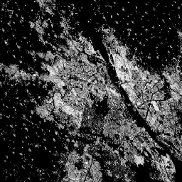
World Settlement Footprint 2015

世界聚落足迹 (WSF) 2015 是一张分辨率为 10 米的二元掩码,用于勾勒全球人类聚落的范围,该掩码是根据 2014-2015 年的多时相 Landsat-8 和 Sentinel-1 影像(分别处理了约 217,000 个和约 107,000 个场景)得出的。人类聚居地的时空动态变化… landcover landsat-derived population sentinel1-derived settlement urban
Datasets tagged landcover in Earth Engine
[null,null,[],[],["Datasets primarily provide global, regional, or national land cover and related data. Key actions include creating maps of crop types (Canada AAFC), land cover (Cote d'Ivoire BNETD, Copernicus CORINE), burned areas (FireCCI51), and human settlements (World Settlement Footprint). Global land surface status is monitored (Copernicus CGLS), as is human impact (CSP gHM). Annual or seasonal crop and land cover mapping (ESA WorldCereal/Cover) is present, as well as glacier surveys (GLIMS) and near real-time land use/land cover updates (Dynamic World V1). There is also change detection (Google CCDC).\n"]]