- Dostępność zbioru danych
- 2009-01-01T00:00:00Z–2010-01-01T00:00:00Z
- Dostawca zbioru danych
- ESA
- Tagi
Opis
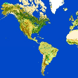
GlobCover 2009 to globalna mapa pokrycia terenu oparta na danych z spektrometru obrazującego o średniej rozdzielczości (MERIS) poziomu 1B, które zostały uzyskane przez satelitę ENVISAT w trybie pełnej rozdzielczości o rozdzielczości przestrzennej wynoszącej około 300 metrów.
Pasma
Rozmiar piksela
300 metrów
Pasma
| Nazwa | Rozmiar piksela | Opis | |||||||||||||||||||||||||||||||||||||||||||||||||||||||||||||||||||||||||||||||||||||||||||||||||
|---|---|---|---|---|---|---|---|---|---|---|---|---|---|---|---|---|---|---|---|---|---|---|---|---|---|---|---|---|---|---|---|---|---|---|---|---|---|---|---|---|---|---|---|---|---|---|---|---|---|---|---|---|---|---|---|---|---|---|---|---|---|---|---|---|---|---|---|---|---|---|---|---|---|---|---|---|---|---|---|---|---|---|---|---|---|---|---|---|---|---|---|---|---|---|---|---|---|---|---|
landcover |
metry | Mapa pokrycia terenu została utworzona na podstawie automatycznej i dostosowanej regionalnie klasyfikacji szeregu czasowego globalnych mozaik MERIS FR z 2009 roku. Globalna mapa pokrycia terenu zawiera 22 klasy pokrycia terenu zdefiniowane w systemie klasyfikacji pokrycia terenu (LCCS) Organizacji Narodów Zjednoczonych (ONZ). |
|||||||||||||||||||||||||||||||||||||||||||||||||||||||||||||||||||||||||||||||||||||||||||||||||
qa |
metry | Binarny zakres jakości wskazujący, czy zamiast danych wyjściowych schematu klasyfikacji GlobCover użyto referencyjnego zbioru danych. |
|||||||||||||||||||||||||||||||||||||||||||||||||||||||||||||||||||||||||||||||||||||||||||||||||
Tabela klas pokrycia terenu
| Wartość | Kolor | Opis |
|---|---|---|
| 11 | #aaefef | zalane lub nawadniane grunty uprawne; |
| 14 | #ffff63 | Uprawy zależne od opadów |
| 20 | #dcef63 | Mozaika pól uprawnych (50–70%) / roślinności (łąki, zarośla, lasy) (20–50%) |
| 30 | #cdcd64 | Mozaika roślinności (łąki, zarośla, lasy) (50–70%) / grunty orne (20–50%) |
| 40 | #006300 | Zamknięty do otwartego (>15%) las liściasty wiecznie zielony lub półzimozielony (>5 m) |
| 50 | #009f00 | Zamknięty (>40%) las liściasty zrzucający liście na zimę (>5 m) |
| 60 | #aac700 | Otwarty (15–40%) las liściasty zrzucający liście na zimę (>5 m) |
| 70 | #003b00 | Zwarcie (>40%) iglastego lasu wiecznie zielonego (>5 m) |
| 90 | #286300 | Otwarty (15–40%) las iglasty liściasty lub zimozielony (>5 m) |
| 100 | #788300 | Zamknięty do otwartego (>15%) mieszanego lasu liściastego i iglastego (>5 m) |
| 110 | #8d9f00 | Mozaika lasów i zarośli (50–70%) / łąk (20–50%) |
| 120 | #bd9500 | Mozaika łąk (50–70%) i lasów zaroślowych (20–50%) |
| 130 | #956300 | Zamknięte do otwartego (>15%) zarośla (<5 m) |
| 140 | #ffb431 | Zamknięte do otwartych (>15%) terenów trawiastych |
| 150 | #ffebae | Rzadka (>15%) roślinność (rośliny drzewiaste, krzewy, trawy) |
| 160 | #00785a | Zamknięty (>40%) las liściasty regularnie zalewany – woda słodka |
| 170 | #009578 | Zamknięty (>40%) las liściasty półzrzucający liście i/lub wiecznie zielony regularnie zalewany wodą słoną |
| 180 | #00dc83 | Zamknięta do otwartej (>15%) roślinność (trawy, krzewy, roślinność drzewiasta) na regularnie zalewanej lub podmokłej glebie – woda słodka, słonawa lub słona |
| 190 | #c31300 | Powierzchnie sztuczne i powiązane z nimi obszary (obszary miejskie >50%) GLOBCOVER 2009 |
| 200 | #fff5d6 | niezalesione obszary, |
| 210 | #0046c7 | Zbiorniki wodne |
| 220 | #ffffff | Stały śnieg i lód |
| 230 | #743411 | Niesklasyfikowany |
Warunki korzystania z usługi
Warunki korzystania z usługi
Produkty GlobCover zostały przetworzone przez ESA i Université Catholique de Louvain. Są one udostępniane publicznie przez ESA. Możesz używać mapy pokrycia terenu GlobCover do celów edukacyjnych lub naukowych bez opłat, pod warunkiem że podasz ESA i Université Catholique de Louvain jako źródło produktów GlobCover.
Cytaty
ESA 2010 i UCLouvain. http://due.esrin.esa.int/page_globcover.php
Odkrywanie za pomocą Earth Engine
Edytor kodu (JavaScript)
var dataset = ee.Image('ESA/GLOBCOVER_L4_200901_200912_V2_3');
var landcover = dataset.select('landcover');
Map.setCenter(-88.6, 26.4, 3);
Map.addLayer(landcover, {}, 'Landcover');