- ডেটাসেট উপলব্ধতা
- 1993-01-01T00:00:00Z–2021-06-16T00:00:00Z
- ডেটাসেট প্রদানকারী
- এস্তোনিয়া অর্থোফটোস
- ট্যাগ
বর্ণনা
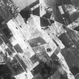
অর্থোফোটোস হল এস্তোনিয়া জুড়ে একটি বায়বীয় ফটো ডেটাসেট।
অরথোফটো হল একটি প্রক্রিয়াকৃত বায়বীয় ছবি যেখান থেকে ভূখণ্ডের ত্রাণ, এক্সপোজারের মুহুর্তে ভূমির সাপেক্ষে ক্যামেরার কাত এবং ক্যামেরা কেন্দ্রীয় অভিক্ষেপের কারণে সৃষ্ট বিকৃতিগুলি সরানো হয়। একটি ডিজিটাল অর্থোফটোর একটি নির্দিষ্ট পিক্সেল আকার বা রেজোলিউশন থাকে যা মাটিতে ক্ষুদ্রতম অবিভাজ্য উন্মুক্ত এলাকা দেখায় (গ্রাউন্ড স্যাম্পলিং দূরত্ব, জিএসডি)।
অর্থোফোটোগুলির একটি দেশব্যাপী কভারেজ রয়েছে এবং এটি 1:5000-1:10000 (পিক্সেল আকার 20-40 সেমি) স্কেলের সাথে মিলে যায়। ঘনবসতিপূর্ণ এলাকার জন্য অর্থোফোটো 10-16 সেমি পিক্সেল আকারের সাথে উত্পাদিত হয়।
মনো ডেটাসেটে দেশব্যাপী কভারেজ সহ একটি একক গ্রেস্কেল ব্যান্ড রয়েছে।
আরও তথ্যের জন্য, অনুগ্রহ করে এস্তোনিয়া অর্থোফটোস ডকুমেন্টেশন দেখুন
ব্যান্ড
পিক্সেল সাইজ
0.4 মিটার
ব্যান্ড
| নাম | মিন | সর্বোচ্চ | পিক্সেল সাইজ | বর্ণনা |
|---|---|---|---|---|
mono | 0 | 255 | মিটার | গ্রেস্কেল |
ব্যবহারের শর্তাবলী
ব্যবহারের শর্তাবলী
ডেটাটি একটি অ-নির্দিষ্ট মেয়াদের জন্য বাণিজ্যিক এবং অ-বাণিজ্যিক উদ্দেশ্যে ব্যবহার করার জন্য বিনামূল্যে, যদি ডেটার শিরোনাম এবং বয়স সহ লাইসেন্সদাতাকে (যেমন এস্তোনিয়ান ল্যান্ড বোর্ড) যথাযথ অ্যাট্রিবিউশন দেওয়া হয়।
আরো বিস্তারিত জানার জন্য ব্যবহারের শর্তাবলী দেখুন
উদ্ধৃতি
মানচিত্রের তথ্য: এস্তোনিয়ান ল্যান্ড বোর্ড
আর্থ ইঞ্জিন দিয়ে অন্বেষণ করুন
কোড এডিটর (জাভাস্ক্রিপ্ট)
var dataset = ee.ImageCollection('Estonia/Maamet/orthos/mono');
Map.setCenter(26.61312, 58.5879, 15);
Map.addLayer(dataset, null, 'Estonia Maamet mono');