- در دسترس بودن مجموعه دادهها
- 1992-01-01T00:00:00Z–2018-01-01T00:00:00Z
- تولیدکننده مجموعه داده
- سازمان خواربار و کشاورزی ملل متحد (فائو)
- کادانس
- ۱ سال
- برچسبها
توضیحات
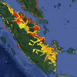
دو مجموعه داده مرتبط فائو در مورد خاکهای آلی زهکشیشده، تخمینهایی از موارد زیر ارائه میدهند:
DROSA-A: مساحت خاکهای آلی (برحسب هکتار) که برای فعالیتهای کشاورزی زهکشی شدهاند (زمینهای زراعی و مراتع چرای دام)
DROSE-A: تخمین کربن (C) و اکسید نیتروژن (N2O) (برحسب گیگاگرم) از زهکشی کشاورزی خاکهای آلی تحت این کاربریها.
دادههای سالانه با وضوح ۰.۰۰۸۳۳۳۳۳ × ۰.۰۰۸۳۳۳۳۳ (حدود ۱ کیلومتر در خط استوا)، با پوشش جهانی برای دوره ۱۹۹۲ تا ۲۰۱۸ در دسترس هستند.
تخمینهای FAOSTAT از دستورالعملهای هیئت بین دولتی تغییرات اقلیمی (IPCC) پیروی میکنند و از هیستوسولها به عنوان نمایندهای برای وجود خاکهای آلی و نقشههای سالانه پوشش زمین به عنوان مؤلفه وابسته به زمان استفاده میکنند. علاوه بر این، ویژگیهای خاک، کاربری زمین و اطلاعات اقلیمی در تجزیه و تحلیل اعمال میشوند. انتشار کربن را میتوان با ضرب مقادیر پیکسل در نسبت وزن مولکولی دی اکسید کربن (CO2) به کربن (44/12) به CO2 تبدیل کرد.
خاکهای آلی در اکوسیستمهای خاک مرطوب توسعه مییابند. این خاکها شامل پیتزارهای گرمسیری و شمالی، باتلاقهای عرض جغرافیایی بالا، سرخسها و باتلاقها میشوند. خاکهای آلی در سطح جهان تنها ۳ درصد از مساحت خشکیها را پوشش میدهند، اما تا ۳۰ درصد از کل کربن خاک را تشکیل میدهند و بنابراین نقش مهمی در حفظ تعادل کربن زمین ایفا میکنند. کشاورزی یکی از دلایل اصلی زهکشی خاکهای آلی در سراسر جهان است. زهکشی، ماده آلی خاکهای آلی را در معرض شرایط هوازی قرار میدهد که اکسید میشود و مقادیر زیادی گازهای گلخانهای مضر (GHG) را به جو آزاد میکند.
DROSA-A و DROSE-A مبنای آمار کشوری و منطقهای در مورد خاکهای آلی زهکشیشده هستند که در سه مجموعه داده FAOSTAT (کشت خاکهای آلی؛ زمینهای زراعی؛ و مراتع) منتشر شدهاند.
باندها
باندها
اندازه پیکسل: ۹۲۷.۶۷ متر (همه باندها)
| نام | واحدها | اندازه پیکسل | توضیحات |
|---|---|---|---|
cropland | هکتار | ۹۲۷.۶۷ متر | مساحت خاکهای آلی زمینهای کشاورزی (هیستوسولها) |
grassland | هکتار | ۹۲۷.۶۷ متر | مساحت خاکهای آلی علفزار (هیستوسولها) |
شرایط استفاده
شرایط استفاده
سازمان خواربار و کشاورزی ملل متحد (FAO) موظف به جمعآوری، تجزیه و تحلیل، تفسیر و انتشار اطلاعات مربوط به تغذیه، غذا و کشاورزی است. در این راستا، تعدادی پایگاه داده در مورد موضوعات مرتبط با ماموریت FAO منتشر میکند و استفاده از آنها را برای اهداف علمی و تحقیقاتی تشویق میکند. مطابق با اصول باز بودن و اشتراکگذاری پیشبینی شده در مجوز دادههای باز برای پایگاههای داده آماری، و مطابق با ماموریت FAO، دادههای مربوط به انتشار گازهای گلخانهای ناشی از فعالیتهای کشاورزی در خاکهای آلی به عنوان بخشی از FAOSTAT - پایگاه داده FAO در مورد دادههای غذا و کشاورزی - به صورت رایگان در دسترس جامعه کاربران قرار میگیرد.
نقل قولها
فائو ۲۰۲۰. خاکهای آلی زهکشیشده ۱۹۹۰-۲۰۱۹. روندهای جهانی، منطقهای و کشوری. مجموعه خلاصه تحلیلی FAOSTAT شماره ۴، فائو، رم. http://www.fao.org/3/cb0489en/cb0489en.pdf
کونچدا، جی. و توبیلو، اف.ان: زهکشی خاکهای آلی و انتشار گازهای گلخانهای: اعتبارسنجی با دادههای کشوری، Earth Syst. Sci. Data Discuss، 2022، doi:10.5194/essd-12-3113-2020
DOI ها
با موتور زمین کاوش کنید
ویرایشگر کد (جاوااسکریپت)
var dataset = ee.ImageCollection('FAO/GHG/1/DROSA_A');

var visualization = {
  bands: ['cropland'],
  min: 1.0,
  max: 60.0,
  palette: ['white', 'red']
};

Map.setCenter(108.0, -0.4, 6);

Map.addLayer(dataset, visualization, 'Cropland area drained (Annual)');