- Disponibilidad del conjunto de datos
- 2000-11-01T00:00:00Z–2026-04-20T00:00:00Z
- Proveedor del conjunto de datos
- NASA / LANCE / EOSDIS
- Cadencia
- 1 día
- Etiquetas
Descripción
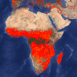
La versión de Earth Engine del conjunto de datos de Fire Information for Resource Management System (FIRMS) contiene el producto de detección de incendios de LANCE en formato rasterizado. LANCE procesa las ubicaciones de incendios activos casi en tiempo real (NRT) con el producto estándar de anomalías térmicas y de incendios MOD14/MYD14 de MODIS. Cada ubicación de incendio activo representa el centroide de un píxel de 1 km marcado por el algoritmo como un píxel que contiene uno o más incendios. Los datos se rasterizan de la siguiente manera: para cada punto de incendio activo de FIRMS, se define un cuadro delimitador (BB) de 1 km, se identifican los píxeles en la proyección sinusoidal de MODIS que intersecan con ese cuadro y, si varios puntos intersecan el mismo píxel, se conserva el que tiene mayor confianza y, en caso de empate, se conserva el más brillante.
Los datos del conjunto de datos casi en tiempo real no se consideran de calidad científica.
Puedes encontrar información adicional aquí.
NOTA: También están disponibles los conjuntos de datos de VIIRS FIRMS de NOAA20 y SUOMI:
Bandas
Bandas
Tamaño de píxel: 1,000 metros (todas las bandas)
| Nombre | Unidades | Mín. | Máx. | Tamaño de los píxeles | Descripción |
|---|---|---|---|---|---|
T21 |
K | 300* | 509.29* | 1,000 metros | Temperatura de brillo de un píxel de incendio que usa los canales 21 y 22 de MODIS. |
confidence |
% | 0 | 100 | 1,000 metros | Nivel de confianza de detección que tiene como objetivo ayudar a los usuarios a evaluar la calidad de los píxeles de incendios activos individuales. La estimación de confianza varía entre el 0% y el 100% para todos los píxeles de incendio dentro de la máscara de incendio. El campo de confianza debe usarse con precaución, ya que es probable que su significado varíe en diferentes partes del mundo. |
line_number |
1* | 35,302* | 1,000 metros | Número de línea en el archivo CSV de FIRMS del que provino el píxel. |
Condiciones de Uso
Condiciones de Uso
La NASA promueve el intercambio completo y abierto de todos los datos con las comunidades de investigación y aplicaciones, la industria privada, el ámbito académico y el público en general. Lee la Política de Datos e Información de la NASA.
Si proporcionas los datos de Land, Atmosphere Near real-time Capability for EOS (LANCE) o Fire Information for Resource Management System (FIRMS) a un tercero, sigue los lineamientos del sitio de LANCE Citation, Acknowledgements, and Disclaimer y replica o proporciona un vínculo al descargo de responsabilidad.
Citas
MODIS Collection 6 NRT Hotspot / Active Fire Detections MCD14DL. Disponible en línea en https://earthdata.nasa.gov/firms. doi:10.5067/FIRMS/MODIS/MCD14DL.NRT.006
Explora con Earth Engine
Editor de código (JavaScript)
var dataset = ee.ImageCollection('FIRMS').filter(
    ee.Filter.date('2018-08-01', '2018-08-10'));
var fires = dataset.select('T21');
var firesVis = {
  min: 325.0,
  max: 400.0,
  palette: ['red', 'orange', 'yellow'],
};
Map.setCenter(-119.086, 47.295, 6);
Map.addLayer(fires, firesVis, 'Fires');