- Dostępność zbioru danych
- 2000-11-01T00:00:00Z–2026-05-31T00:00:00Z
- Producent zbioru danych
- NASA / LANCE / EOSDIS
- Częstotliwość
- 1 dzień
- Tagi
Opis
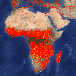
Wersja zbioru danych Fire Information for Resource Management System (FIRMS) w Earth Engine zawiera produkt LANCE do wykrywania pożarów w postaci rastrowej. Lokalizacje aktywnych pożarów w czasie zbliżonym do rzeczywistego (NRT) są przetwarzane przez LANCE przy użyciu standardowego produktu MODIS MOD14/MYD14 Fire and Thermal Anomalies. Każda lokalizacja aktywnego pożaru reprezentuje środek piksela o rozmiarze 1 km, który został oznaczony przez algorytm jako zawierający co najmniej 1 pożar. Dane są rasteryzowane w ten sposób: dla każdego punktu aktywnego pożaru FIRMS definiowana jest ramka ograniczająca o boku 1 km; identyfikowane są piksele w rzucie sinusoidalnym MODIS, które przecinają ramkę ograniczającą FIRMS; jeśli kilka ramek ograniczających FIRMS przecina ten sam piksel, zachowywana jest ta o większym poziomie ufności; w przypadku remisu zachowywany jest jaśniejszy piksel.
Dane w zbiorze danych w czasie zbliżonym do rzeczywistego nie są uznawane za dane naukowe.
Dodatkowe informacje znajdziesz tutaj.
UWAGA: dostępne są też zbiory danych VIIRS FIRMS z NOAA20 i SUOMI:
Pasma
Pasma
Rozmiar piksela: 1000 metrów (wszystkie pasma)
| Nazwa | Jednostki | Min. | Maks. | Rozmiar piksela | Opis |
|---|---|---|---|---|---|
T21 |
K | 300* | 509,29* | 1000 metrów | Temperatura jasności piksela pożaru przy użyciu kanałów MODIS 21/22. |
confidence |
% | 0 | 100 | 1000 metrów | Poziom ufności wykrycia, który ma pomóc użytkownikom ocenić jakość poszczególnych pikseli aktywnego pożaru. Szacowany poziom ufności wynosi od 0% do 100% w przypadku wszystkich pikseli pożaru w masce pożaru. Pola ufności należy używać ostrożnie, ponieważ ich znaczenie może się różnić w zależności od regionu. |
line_number |
1* | 35302* | 1000 metrów | Numer wiersza w pliku CSV FIRMS, z którego pochodzi piksel. |
Warunki korzystania z usługi
Warunki korzystania z usługi
NASA promuje pełne i otwarte udostępnianie wszystkich danych społecznościom badawczym i związanym z aplikacją, sektorowi prywatnemu, środowisku akademickiemu i ogółowi społeczeństwa. Zapoznaj się z zasadami NASA dotyczącymi danych i informacji.
Jeśli udostępniasz dane Land, Atmosphere Near real-time Capability for EOS (LANCE) / Fire Information for Resource Management System (FIRMS) osobom trzecim, postępuj zgodnie z wytycznymi podanymi na stronie LANCE Citation, Acknowledgements, and Disclaimer i powiel lub podaj link do zastrzeżenia.
Cytaty
MODIS Collection 6 NRT Hotspot / Active Fire Detections MCD14DL. Dostępne online: https://earthdata.nasa.gov/firms. doi:10.5067/FIRMS/MODIS/MCD14DL.NRT.006
Odkrywaj za pomocą Earth Engine
Edytor kodu (JavaScript)
var dataset = ee.ImageCollection('FIRMS').filter(
    ee.Filter.date('2018-08-01', '2018-08-10'));
var fires = dataset.select('T21');
var firesVis = {
  min: 325.0,
  max: 400.0,
  palette: ['red', 'orange', 'yellow'],
};
Map.setCenter(-119.086, 47.295, 6);
Map.addLayer(fires, firesVis, 'Fires');
import ee
import geemap.core as geemap
Colab (Python)
dataset = ee.ImageCollection('FIRMS').filter(
    ee.Filter.date('2018-08-01', '2018-08-10')
)

fires = dataset.select('T21')

fires_vis = {'min': 325.0, 'max': 400.0, 'palette': ['red', 'orange', 'yellow']}

m = geemap.Map()
m.set_center(-119.086, 47.295, 6)
m.add_layer(fires, fires_vis, 'Fires')
m