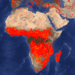
Kaynak Yönetimi için Yangın Bilgileri Sistemi (FIRMS) veri kümesinin Earth Engine sürümü, rasterleştirilmiş biçimde LANCE yangın tespit ürününü içerir. Neredeyse gerçek zamanlı (NRT) aktif yangın konumları, standart MODIS MOD14/MYD14 Yangın ve Termal Anormallikler ürünü kullanılarak LANCE tarafından işlenir. Her aktif yangın konumu, algoritma tarafından piksel içinde bir veya daha fazla yangın içerdiği belirtilen 1 km'lik bir pikselin merkezini temsil eder. Veriler şu şekilde rasterleştirilir: Her bir FIRMS aktif yangın noktası için 1 km'lik bir sınırlayıcı kutu (BB) tanımlanır; MODIS sinüs projeksiyonunda FIRMS BB ile kesişen pikseller belirlenir; aynı pikselle birden fazla FIRMS BB kesişiyorsa daha yüksek güvene sahip olan korunur; eşitlik durumunda ise daha parlak olan korunur.
Neredeyse gerçek zamanlı veri kümesindeki veriler bilimsel kalitede kabul edilmez.
MODIS kanalları 21/22 kullanılarak bir yangın pikselinin parlaklık sıcaklığı.
confidence
%
0
100
metre
Kullanıcıların tek tek etkin yangın piksellerinin kalitesini değerlendirmesine yardımcı olmak için tasarlanmış bir algılama güveni. Güven tahmini, yangın maskesindeki tüm yangın pikselleri için% 0 ile% 100 arasında değişir. Güven alanı dikkatli kullanılmalıdır. Dünyanın farklı bölgelerinde anlamı değişebilir.
line_number
1*
35302*
metre
Pikselin geldiği FIRMS CSV dosyasındaki satır numarası.
* tahmini minimum veya maksimum değer
Kullanım Şartları
Kullanım Şartları
NASA, tüm verilerin araştırma ve uygulama toplulukları, özel sektör, akademi ve halkla tam ve açık bir şekilde paylaşılmasını teşvik eder. NASA Veri ve Bilgi Politikası'nı okuyun.
Kaynak Yönetimi Sistemi İçin Yangın Bilgileri (FIRMS) veri kümesinin Earth Engine sürümü, rasterleştirilmiş biçimde LANCE yangın tespit ürününü içerir. Neredeyse anlık (NRT) aktif yangın konumları, standart MODIS MOD14/MYD14 Yangın ve Termal Anormallikler ürünü kullanılarak LANCE tarafından işlenir. Her etkin yangın konumu, …
[null,null,[],[[["\u003cp\u003eFIRMS provides near real-time (NRT) active fire data, derived from the MODIS MOD14/MYD14 Fire and Thermal Anomalies product and presented in rasterized form.\u003c/p\u003e\n"],["\u003cp\u003eEach active fire location in the dataset represents the centroid of a 1km pixel flagged by the algorithm as containing one or more fires.\u003c/p\u003e\n"],["\u003cp\u003eThe data are considered to be near real-time and not of science quality, with a confidence estimate provided for each fire pixel.\u003c/p\u003e\n"],["\u003cp\u003eThe dataset covers the period from 2000-11-01 to 2024-12-11 and is provided by NASA/LANCE/EOSDIS.\u003c/p\u003e\n"],["\u003cp\u003eVIIRS FIRMS datasets from NOAA20 and SUOMI are also available as separate datasets within the Earth Engine catalog.\u003c/p\u003e\n"]]],["The Fire Information for Resource Management System (FIRMS) dataset, provided by NASA/LANCE/EOSDIS, contains near real-time active fire locations from 2000-11-01 to 2025-02-22. These fire locations, detected using MODIS data, are rasterized as 1km pixels, with higher confidence and brighter pixels prioritized when multiple fire points overlap. The dataset, accessible via Earth Engine using `ee.ImageCollection(\"FIRMS\")`, includes bands like `T21` (temperature), `confidence` (detection quality), and `line_number` (origin in the data file). The data is not considered science-quality.\n"],null,["Dataset Availability\n: 2000-11-01T00:00:00Z--2025-08-31T00:00:00Z\n\nDataset Provider\n:\n\n\n [NASA / LANCE / EOSDIS](https://earthdata.nasa.gov/earth-observation-data/near-real-time/firms)\n\nCadence\n: 1 Day\n\nTags\n:\n[eosdis](/earth-engine/datasets/tags/eosdis) [fire](/earth-engine/datasets/tags/fire) [firms](/earth-engine/datasets/tags/firms) [geophysical](/earth-engine/datasets/tags/geophysical) [hotspot](/earth-engine/datasets/tags/hotspot) [lance](/earth-engine/datasets/tags/lance) [modis](/earth-engine/datasets/tags/modis) [nasa](/earth-engine/datasets/tags/nasa) [thermal](/earth-engine/datasets/tags/thermal) \n\nDescription \nThe Earth Engine version of the Fire Information for Resource Management\nSystem (FIRMS) dataset contains the LANCE fire detection product in\nrasterized form. The near real-time (NRT) active fire locations are\nprocessed by LANCE using the standard MODIS MOD14/MYD14 Fire and Thermal\nAnomalies product. Each active fire location represents the centroid of a\n1km pixel that is flagged by the algorithm as containing one or more fires\nwithin the pixel. The data are rasterized as follows: for each FIRMS active\nfire point, a 1km bounding box (BB) is defined; pixels in the MODIS\nsinusoidal projection that intersect the FIRMS BB are identified; if\nmultiple FIRMS BBs intersect the same pixel, the one with higher confidence\nis retained; in case of a tie, the brighter one is retained.\n\nThe data in the near-real-time dataset are not considered to be of science\nquality.\n\nAdditional information can be found [here](https://firms.modaps.eosdis.nasa.gov/).\n\nNOTE: VIIRS FIRMS datasets from NOAA20 and SUOMI are also available:\n\n- [NASA/LANCE/NOAA20_VIIRS/C2](/earth-engine/datasets/catalog/NASA_LANCE_NOAA20_VIIRS_C2)\n- [NASA/LANCE/SNPP_VIIRS/C2](/earth-engine/datasets/catalog/NASA_LANCE_SNPP_VIIRS_C2)\n\nBands\n\n\n**Pixel Size**\n\n1000 meters\n\n**Bands**\n\n| Name | Units | Min | Max | Pixel Size | Description |\n|---------------|-------|-------|----------|------------|-----------------------------------------------------------------------------------------------------------------------------------------------------------------------------------------------------------------------------------------------------------------------------------------------------------------------------|\n| `T21` | K | 300\\* | 509.29\\* | meters | The brightness temperature of a fire pixel using MODIS channels 21/22. |\n| `confidence` | % | 0 | 100 | meters | A detection confidence intended to help users gauge the quality of individual active fire pixels. The confidence estimate ranges between 0% and 100% for all fire pixels within the fire mask. The confidence field should be used with caution; it is likely that it will vary in meaning in different parts of the world. |\n| `line_number` | | 1\\* | 35302\\* | meters | Line number in the FIRMS CSV file that the pixel came from. |\n\n\\* estimated min or max value\n\nTerms of Use\n\n**Terms of Use**\n\nNASA promotes the full and open sharing of all data with the research and\napplications communities, private industry, academia, and the general\npublic. Read the [NASA Data and Information Policy](https://www.earthdata.nasa.gov/learn/use-data/data-use-policy).\n\nIf you provide the\n[Land, Atmosphere Near real-time Capability for EOS (LANCE) / Fire Information for Resource Management System (FIRMS)](https://earthdata.nasa.gov/earth-observation-data/near-real-time)\ndata to a third party, follow the guidelines in the\n[LANCE Citation, Acknowledgements, and Disclaimer](https://earthdata.nasa.gov/earth-observation-data/near-real-time/citation#ed-lance-disclaimer)\nsite and replicate or provide a link to the\n[disclaimer](https://earthdata.nasa.gov/earth-observation-data/near-real-time/citation#ed-lance-disclaimer).\n\nCitations \nCitations:\n\n- MODIS Collection 6 NRT Hotspot / Active Fire Detections MCD14DL.\n Available on-line \u003chttps://earthdata.nasa.gov/firms\u003e.\n [doi:10.5067/FIRMS/MODIS/MCD14DL.NRT.006](https://doi.org/10.5067/FIRMS/MODIS/MCD14DL.NRT.006)\n\nExplore with Earth Engine **Important:** Earth Engine is a platform for petabyte-scale scientific analysis and visualization of geospatial datasets, both for public benefit and for business and government users. Earth Engine is free to use for research, education, and nonprofit use. To get started, please [register for Earth Engine access.](https://console.cloud.google.com/earth-engine)\n\nCode Editor (JavaScript) \n\n```javascript\nvar dataset = ee.ImageCollection('FIRMS').filter(\n ee.Filter.date('2018-08-01', '2018-08-10'));\nvar fires = dataset.select('T21');\nvar firesVis = {\n min: 325.0,\n max: 400.0,\n palette: ['red', 'orange', 'yellow'],\n};\nMap.setCenter(-119.086, 47.295, 6);\nMap.addLayer(fires, firesVis, 'Fires');\n```\n[Open in Code Editor](https://code.earthengine.google.com/?scriptPath=Examples:Datasets/FIRMS/FIRMS) \n[FIRMS: Fire Information for Resource Management System](/earth-engine/datasets/catalog/FIRMS) \nThe Earth Engine version of the Fire Information for Resource Management System (FIRMS) dataset contains the LANCE fire detection product in rasterized form. The near real-time (NRT) active fire locations are processed by LANCE using the standard MODIS MOD14/MYD14 Fire and Thermal Anomalies product. Each active fire location represents the ... \nFIRMS, eosdis,fire,firms,geophysical,hotspot,lance,modis,nasa,thermal \n2000-11-01T00:00:00Z/2025-08-31T00:00:00Z \n-90 -180 90 180 \nGoogle Earth Engine \nhttps://developers.google.com/earth-engine/datasets\n\n- [](https://doi.org/https://earthdata.nasa.gov/earth-observation-data/near-real-time/firms)\n- [](https://doi.org/https://developers.google.com/earth-engine/datasets/catalog/FIRMS)"]]