-
FIRMS: Resource Management System için Yangın Bilgileri
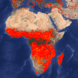
Resource Management System (FIRMS) veri kümesinin Earth Engine sürümü, LANCE yangın algılama ürününü rasterleştirilmiş biçimde içerir. Neredeyse gerçek zamanlı (NRT) etkin yangın konumları, standart MODIS MOD14/MYD14 Yangın ve Termal Anormallikler ürünü kullanılarak LANCE tarafından işlenir. Her … eosdis fire firms geophysical hotspot lance -
VJ114IMGTDL_NRT Günlük Raster: VIIRS (NOAA-20) Band 375m Aktif Yangın
NOAA-20 (JPSS-1) Görünür Kızılötesi Görüntüleme Radyometresi Paketi (VIIRS) Etkin Yangın Algılama ürünü, cihazın 375 m nominal çözünürlük verilerini temel alır. Daha düşük çözünürlüklü (≥ 1 km) diğer uydu yangın algılama ürünlerine kıyasla, iyileştirilmiş 375 m verileri nispeten küçük yangınlar için daha fazla yanıt sağlar. eosdis fire firms geophysical hotspot lance -
VNP14IMGTDL_NRT Günlük Raster: VIIRS (S-NPP) Band 375m Aktif Yangın
Suomi NPP Görünür Kızılötesi Görüntüleme Radyometresi Paketi (VIIRS) Etkin Yangın Algılama ürünü, cihazın 375 m nominal çözünürlük verilerini temel alır. Daha düşük çözünürlüklü (≥ 1 km) diğer uydu yangın algılama ürünlerine kıyasla, iyileştirilmiş 375 m verileri nispeten küçük yangınlar için daha fazla yanıt sağlar. eosdis fire firms geophysical hotspot lance
Datasets tagged eosdis in Earth Engine
[null,null,[],[[["\u003cp\u003eThe Fire Information for Resource Management System (FIRMS) dataset provides near real-time active fire locations based on the MODIS MOD14/MYD14 Fire and Thermal Anomalies product.\u003c/p\u003e\n"],["\u003cp\u003eThe VIIRS Active Fire detection product offers improved 375m resolution data for greater response over smaller fires, available for both NOAA-20 and Suomi NPP satellites.\u003c/p\u003e\n"],["\u003cp\u003eAll datasets utilize LANCE (Land, Atmosphere Near real-time Capability for EOS) for fire detection and are available through Earth Engine.\u003c/p\u003e\n"]]],[],null,["# Datasets tagged eosdis in Earth Engine\n\n-\n\n |-----------------------------------------------------------------------------------------------------------------------------------------------------------------------------------------------------------------------------------------------------------------------------------------------------------------------|\n | [### FIRMS: Fire Information for Resource Management System](/earth-engine/datasets/catalog/FIRMS) |\n | The Earth Engine version of the Fire Information for Resource Management System (FIRMS) dataset contains the LANCE fire detection product in rasterized form. The near real-time (NRT) active fire locations are processed by LANCE using the standard MODIS MOD14/MYD14 Fire and Thermal Anomalies product. Each ... |\n | [eosdis](/earth-engine/datasets/tags/eosdis) [fire](/earth-engine/datasets/tags/fire) [firms](/earth-engine/datasets/tags/firms) [geophysical](/earth-engine/datasets/tags/geophysical) [hotspot](/earth-engine/datasets/tags/hotspot) [lance](/earth-engine/datasets/tags/lance) |\n\n-\n\n |---------------------------------------------------------------------------------------------------------------------------------------------------------------------------------------------------------------------------------------------------------------------------------------------------------------------------------|\n | [### VJ114IMGTDL_NRT Daily Raster: VIIRS (NOAA-20) Band 375m Active Fire](/earth-engine/datasets/catalog/NASA_LANCE_NOAA20_VIIRS_C2) |\n | NOAA-20 (JPSS-1) Visible Infrared Imaging Radiometer Suite (VIIRS) Active Fire detection product is based on the instrument's 375m nominal resolution data. Compared to other coarser resolution (≥ 1km) satellite fire detection products, the improved 375 m data provide greater response over fires of relatively small ... |\n | [eosdis](/earth-engine/datasets/tags/eosdis) [fire](/earth-engine/datasets/tags/fire) [firms](/earth-engine/datasets/tags/firms) [geophysical](/earth-engine/datasets/tags/geophysical) [hotspot](/earth-engine/datasets/tags/hotspot) [lance](/earth-engine/datasets/tags/lance) |\n\n-\n\n |--------------------------------------------------------------------------------------------------------------------------------------------------------------------------------------------------------------------------------------------------------------------------------------------------------------------------|\n | [### VNP14IMGTDL_NRT Daily Raster: VIIRS (S-NPP) Band 375m Active Fire](/earth-engine/datasets/catalog/NASA_LANCE_SNPP_VIIRS_C2) |\n | Suomi NPP Visible Infrared Imaging Radiometer Suite (VIIRS) Active Fire detection product is based on the instrument's 375m nominal resolution data. Compared to other coarser resolution (≥ 1km) satellite fire detection products, the improved 375 m data provide greater response over fires of relatively small ... |\n | [eosdis](/earth-engine/datasets/tags/eosdis) [fire](/earth-engine/datasets/tags/fire) [firms](/earth-engine/datasets/tags/firms) [geophysical](/earth-engine/datasets/tags/geophysical) [hotspot](/earth-engine/datasets/tags/hotspot) [lance](/earth-engine/datasets/tags/lance) |"]]