Global Land Ice Measurements from Space (GLIMS) هي مبادرة دولية تهدف إلى إجراء مسح متكرر لنحو 200,000 نهر جليدي في العالم.
يهدف المشروع إلى إنشاء قاعدة بيانات شاملة عالميًا للجليد الأرضي، بما في ذلك قياسات مساحة الأنهار الجليدية وشكلها الهندسي وسرعة سطحها وارتفاع خط الثلج. لإجراء هذه التحليلات، يستعين مشروع GLIMS ببيانات الأقمار الصناعية، بشكل أساسي من جهاز ASTER وجهاز ETM+، بالإضافة إلى المعلومات السابقة المستمدة من الخرائط والصور الجوية.
تمثّل كل ميزة في مجموعة البيانات هذه حدودًا مضلّعة لأحد الأنهار الجليدية في وقت التحليل. تحتوي بعض معرّفات الأنهار الجليدية على مئات الصفوف المميّزة بمرور الوقت.
تمثّل مجموعة البيانات هذه لقطة لحدود الأنهار الجليدية في 7 حزيران (يونيو) 2023، وتوفّر أكثر من 1,100,000 صف.
مخطط الجدول
مخطط الجدول
الاسم
النوع
الوصف
المحلّلون
سلسلة
أسماء المساهمين في البيانات
anlys_id
مزدوج
معرّف نهر جليدي في وقت معيّن
anlys_time
سلسلة
وقت إجراء التحليل
المساحة
مزدوج
مساحة النهر الجليدي في مستوى إسقاط الخريطة بالكيلومترات المربّعة
chief_affl
سلسلة
جهة انتماء رئيس المركز الإقليمي
db_area
مزدوج
كما هو الحال مع "المساحة"، ولكن يتم إعادة احتسابه بواسطة مشروع GLIMS
geog_area
سلسلة
اسم المنطقة الجغرافية التي يغطيها المركز الإقليمي
glac_id
سلسلة
معرّف النهر الجليدي في GLIMS
glac_name
سلسلة
اسم النهر الجليدي 80% تقريبًا من الصفوف تساوي "لا شيء"
glac_stat
سلسلة
حالة النهر الجليدي، إما "موجود" أو "لا شيء"
length
مزدوج
طول محيط النهر الجليدي بالمتر
line_type
سلسلة
نوع سجلّ النهر الجليدي، مثل "glac_bound" للأنهار الجليدية،
أو قيم أخرى للصخور الداخلية وخطوط الثلج والمعالم المائية وما إلى ذلك
local_id
سلسلة
رقم التعريف الذي خصصته المؤسسة المساهمة أو المركز الإقليمي
max_elev
مزدوج
أعلى جزء من النهر الجليدي، بالمتر فوق مستوى سطح البحر
mean_elev
مزدوج
متوسط ارتفاع النهر الجليدي، بالأمتار فوق مستوى سطح البحر
min_elev
مزدوج
أدنى جزء من النهر الجليدي، بالمتر فوق مستوى سطح البحر
parent_id
سلسلة
معرّف النهر الجليدي الذي يمثّل النهر الجليدي الرئيسي لهذا النهر الجليدي
primeclass
مزدوج
رقم تصنيف الأنهار الجليدية في WGMS
proc_desc
سلسلة
وصف المعالجة التي تم إجراؤها على هذا السجلّ
rc_id
مزدوج
رقم التعريف المستخدَم من قِبل المركز الإقليمي
rec_status
سلسلة
حالة السجلّ
release_dt
سلسلة
تاريخ إصدار بيانات التقييم، بالتنسيق YYYY-MM-ddTHH:mm:ss
src_date
سلسلة
تاريخ الصور المصدر المستخدَمة لإنشاء المخطط
subm_id
مزدوج
معرّف الطلب الذي خصّصه نظام GLIMS
المرسِلون
سلسلة
أسماء مُرسِلي البيانات
wgms_id
سلسلة
معرّف "الخدمة العالمية لمراقبة الأنهار الجليدية"
العرض
مزدوج
عرض النهر الجليدي بالمتر
بنود الاستخدام
بنود الاستخدام
عند إنشاء أي تقارير أو منشورات أو مجموعات بيانات جديدة أو منتجات أو خدمات مشتقة ناتجة عن مجموعة البيانات، على المستخدمين الإشارة إلى: GLIMS وNSIDC (2005، تم تعديله في 2013): قاعدة بيانات الأنهار الجليدية العالمية لقياسات الجليد الأرضي من الفضاء. تم تجميعها وإتاحتها من قِبل مجموعة GLIMS الدولية ومركز البيانات الوطني للثلوج والجليد في بولدر، كولورادو، الولايات المتحدة الأمريكية،
doi:10.7265/N5V98602
Global Land Ice Measurements from Space (GLIMS) هي مبادرة دولية تهدف إلى إجراء مسح متكرر لنحو 200,000 نهر جليدي في العالم. يهدف المشروع إلى إنشاء قاعدة بيانات شاملة على مستوى العالم للجليد الأرضي، بما في ذلك قياسات مساحة الأنهار الجليدية وشكلها الهندسي وسرعة سطحها وارتفاع خط الثلج. لإجراء هذه التحليلات، …
[null,null,[],[[["\u003cp\u003e\u003cstrong\u003eCaution:\u003c/strong\u003e This dataset has been replaced by a newer version, GLIMS/20230607.\u003c/p\u003e\n"],["\u003cp\u003eGLIMS is an international project creating a global inventory of glacier boundaries, including measurements of glacier area, geometry, velocity, and snow line elevation.\u003c/p\u003e\n"],["\u003cp\u003eThe dataset comprises over 1,100,000 rows, representing glacier boundaries primarily derived from ASTER and Landsat satellite data.\u003c/p\u003e\n"],["\u003cp\u003eEach feature in the dataset represents a glacier's polygonal boundary at the time of analysis, with attributes like area, elevation, and source imagery date.\u003c/p\u003e\n"],["\u003cp\u003eUsers of this dataset for publications or derived products should cite GLIMS and NSIDC, providing the associated DOI.\u003c/p\u003e\n"]]],[],null,["# GLIMS Current: Global Land Ice Measurements From Space\n\nDataset Availability\n: 1750-01-01T00:00:00Z--2023-06-07T00:00:00Z\n\nDataset Provider\n:\n\n\n [National Snow and Ice Data Center (NSDIC)](https://www.glims.org)\n\nTags\n:\n[cryosphere](/earth-engine/datasets/tags/cryosphere) [glacier](/earth-engine/datasets/tags/glacier) [glims](/earth-engine/datasets/tags/glims) [ice](/earth-engine/datasets/tags/ice) [landcover](/earth-engine/datasets/tags/landcover) [nasa](/earth-engine/datasets/tags/nasa) [nsidc](/earth-engine/datasets/tags/nsidc) [snow](/earth-engine/datasets/tags/snow) [table](/earth-engine/datasets/tags/table) \n\n#### Description\n\nGlobal Land Ice Measurements from Space (GLIMS) is\nan international initiative with the goal of repeatedly surveying\nthe world's estimated 200,000 glaciers.\n\nThe project seeks\nto create a globally comprehensive inventory of land ice, including\nmeasurements of glacier area, geometry, surface velocity, and\nsnow line elevation. To perform these analyses, the GLIMS project\nuses satellite data, primarily from the Advanced Spaceborne Thermal\nEmission and Reflection Radiometer (ASTER) and the Landsat Enhanced\nThematic Mapper Plus (ETM+), as well as historical information\nderived from maps and aerial photographs.\n\nEach feature in this dataset is a polygonal boundary of a glacier at the\ntime of analysis. A few glacier IDs have hundreds of distinct rows over\ntime.\n\nThis dataset is a snapshot of the inventory of glacier boundaries as of\nJune 7, 2023, providing over 1,100,000 rows.\n\n### Table Schema\n\n**Table Schema**\n\n| Name | Type | Description |\n|------------|--------|--------------------------------------------------------------------------------------------------------------------------|\n| analysts | STRING | Name(s) of data contributor(s) |\n| anlys_id | DOUBLE | ID of a glacier at a particular time |\n| anlys_time | STRING | When the analysis was done |\n| area | DOUBLE | Area of the glacier in the plane of the map projection in square kilometers |\n| chief_affl | STRING | Affiliation of the chief of the regional center |\n| db_area | DOUBLE | Same as 'area', but recomputed by the GLIMS project |\n| geog_area | STRING | Name of geographic region covered by the regional center |\n| glac_id | STRING | The GLIMS glacier ID |\n| glac_name | STRING | The glacier name. \\~80% of the rows equal 'None' |\n| glac_stat | STRING | Glacier status, either 'exists' or 'None' |\n| length | DOUBLE | Length of the glacier perimeter in meters |\n| line_type | STRING | Glacier record type, e.g. 'glac_bound' for glaciers, or other values for internal rocks, snowlines, water features, etc. |\n| local_id | STRING | ID assigned by the contributing institution or regional center |\n| max_elev | DOUBLE | Highest part of the glacier, in meters above sea level |\n| mean_elev | DOUBLE | Mean elevation of the glacier, in meters above sea level |\n| min_elev | DOUBLE | Lowest part of the glacier, in meters above sea level |\n| parent_id | STRING | ID of the glacier that is the parent of this glacier |\n| primeclass | DOUBLE | WGMS glacier classification number |\n| proc_desc | STRING | Description of processing done on this record |\n| rc_id | DOUBLE | ID used by the regional center |\n| rec_status | STRING | Record status |\n| release_dt | STRING | Date data was released, in YYYY-MM-ddTHH:mm:ss format |\n| src_date | STRING | Date of source imagery used to create the outline |\n| subm_id | DOUBLE | The submission ID assigned by GLIMS |\n| submitters | STRING | Name(s) of data submitter(s) |\n| wgms_id | STRING | World Glacier Monitoring Service ID |\n| width | DOUBLE | Width of the glacier in meters |\n\n### Terms of Use\n\n**Terms of Use**\n\nFor the creation of any reports, publications, new\ndata sets, derived products, or services resulting from the data\nset, users should cite: GLIMS and NSIDC (2005, updated 2013): Global\nLand Ice Measurements from Space glacier database. Compiled and\nmade available by the international GLIMS community and the National\nSnow and Ice Data Center, Boulder CO, U.S.A.,\n[doi:10.7265/N5V98602](https://doi.org/10.7265/N5V98602)\n\n### DOIs\n\n- \u003chttps://doi.org/10.7265/N5V98602\u003e\n\n### Explore with Earth Engine\n\n| **Important:** Earth Engine is a platform for petabyte-scale scientific analysis and visualization of geospatial datasets, both for public benefit and for business and government users. Earth Engine is free to use for research, education, and nonprofit use. To get started, please [register for Earth Engine access.](https://console.cloud.google.com/earth-engine)\n\n### Code Editor (JavaScript)\n\n```javascript\n
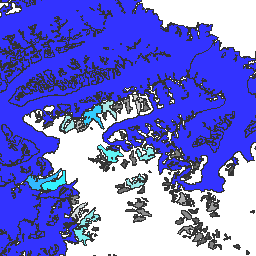
var dataset = ee.FeatureCollection('GLIMS/current');\nvar visParams = {\n palette: ['gray', 'cyan', 'blue'],\n min: 0.0,\n max: 10.0,\n opacity: 0.8,\n};\nvar image = ee.Image().float().paint(dataset, 'area');\nMap.setCenter(-35.618, 66.743, 7);\nMap.addLayer(image, visParams, 'GLIMS/current');\nMap.addLayer(dataset, null, 'for Inspector', false);\n```\n[Open in Code Editor](https://code.earthengine.google.com/?scriptPath=Examples:Datasets/GLIMS/GLIMS_current)\n\n### Visualize as a FeatureView\n\n\nA `FeatureView` is a view-only, accelerated representation of a\n`FeatureCollection`. For more details, visit the\n[`FeatureView` documentation.](/earth-engine/guides/featureview_overview)\n| **Important:** Earth Engine is a platform for petabyte-scale scientific analysis and visualization of geospatial datasets, both for public benefit and for business and government users. Earth Engine is free to use for research, education, and nonprofit use. To get started, please [register for Earth Engine access.](https://console.cloud.google.com/earth-engine)\n\n### Code Editor (JavaScript)\n\n```javascript\nvar fvLayer = ui.Map.FeatureViewLayer('GLIMS/current_FeatureView');\n\nvar visParams = {\n color: {\n property: 'area',\n mode: 'linear',\n palette: ['gray', 'cyan', 'blue'],\n min: 0.0,\n max: 10.0\n },\n opacity: 0.8,\n polygonStrokeOpacity: 0\n};\n\nfvLayer.setVisParams(visParams);\nfvLayer.setName('GLIMS/current');\n\nMap.setCenter(-35.618, 66.743, 7);\nMap.add(fvLayer);\n```\n[Open in Code Editor](https://code.earthengine.google.com/?scriptPath=Examples:Datasets/GLIMS/GLIMS_current_FeatureView) \n[GLIMS Current: Global Land Ice Measurements From Space](/earth-engine/datasets/catalog/GLIMS_current) \nGlobal Land Ice Measurements from Space (GLIMS) is an international initiative with the goal of repeatedly surveying the world's estimated 200,000 glaciers. The project seeks to create a globally comprehensive inventory of land ice, including measurements of glacier area, geometry, surface velocity, and snow line elevation. To perform these analyses, ... \nGLIMS/current, cryosphere,glacier,glims,ice,landcover,nasa,nsidc,snow,table \n1750-01-01T00:00:00Z/2023-06-07T00:00:00Z \n-90 -180 90 180 \nGoogle Earth Engine \nhttps://developers.google.com/earth-engine/datasets\n\n- [https://doi.org/10.7265/N5V98602](https://doi.org/https://www.glims.org)\n- [https://doi.org/10.7265/N5V98602](https://doi.org/https://developers.google.com/earth-engine/datasets/catalog/GLIMS_current)"]]