- ডেটাসেটের উপলভ্যতা
- 1750-01-01T00:00:00Z–2023-06-07T00:00:00Z
- ডেটাসেট প্রযোজক
- জাতীয় তুষার ও বরফ তথ্য কেন্দ্র (NSDIC)
- ট্যাগ
বিবরণ
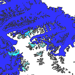
গ্লোবাল ল্যান্ড আইস মেজারমেন্টস ফ্রম স্পেস (GLIMS) হল একটি আন্তর্জাতিক উদ্যোগ যার লক্ষ্য বিশ্বের আনুমানিক ২০০,০০০ হিমবাহ বারবার জরিপ করা।
এই প্রকল্পটি হিমবাহ এলাকা, জ্যামিতি, পৃষ্ঠের বেগ এবং তুষাররেখার উচ্চতা পরিমাপ সহ স্থল বরফের একটি বিশ্বব্যাপী বিস্তৃত তালিকা তৈরি করার লক্ষ্যে কাজ করে। এই বিশ্লেষণগুলি সম্পাদন করার জন্য, GLIMS প্রকল্পটি মূলত অ্যাডভান্সড স্পেসবোর্ন থার্মাল এমিশন অ্যান্ড রিফ্লেকশন রেডিওমিটার (ASTER) এবং ল্যান্ডস্যাট এনহ্যান্সড থিম্যাটিক ম্যাপার প্লাস (ETM+) থেকে প্রাপ্ত স্যাটেলাইট ডেটা, সেইসাথে মানচিত্র এবং বায়বীয় ছবি থেকে প্রাপ্ত ঐতিহাসিক তথ্য ব্যবহার করে।
এই ডেটাসেটের প্রতিটি বৈশিষ্ট্য বিশ্লেষণের সময় একটি হিমবাহের বহুভুজ সীমানা। কিছু হিমবাহ আইডিতে সময়ের সাথে সাথে শত শত স্বতন্ত্র সারি থাকে।
এই ডেটাসেটটি ৭ জুন, ২০২৩ তারিখের হিমবাহের সীমানার তালিকার একটি স্ন্যাপশট, যা ১,১০০,০০০ এরও বেশি সারি প্রদান করে।
টেবিল স্কিমা
টেবিল স্কিমা
| নাম | আদর্শ | বিবরণ |
|---|---|---|
| বিশ্লেষকরা | স্ট্রিং | তথ্য প্রদানকারীর নাম (গুলি) |
| অ্যানালিস_আইডি | দ্বিগুণ | একটি নির্দিষ্ট সময়ে একটি হিমবাহের পরিচয় |
| অ্যানালিস_টাইম | স্ট্রিং | যখন বিশ্লেষণটি সম্পন্ন হয়েছিল |
| এলাকা | দ্বিগুণ | মানচিত্রের প্রক্ষেপণের সমতলে হিমবাহের ক্ষেত্রফল বর্গকিলোমিটারে |
| প্রধান_অ্যাফল | স্ট্রিং | আঞ্চলিক কেন্দ্রের প্রধানের অধিভুক্তি |
| db_area সম্পর্কে | দ্বিগুণ | 'ক্ষেত্র'-এর মতোই, কিন্তু GLIMS প্রকল্প দ্বারা পুনঃগণনা করা হয়েছে |
| ভূ-ক্ষেত্র | স্ট্রিং | আঞ্চলিক কেন্দ্রের আওতাধীন ভৌগোলিক অঞ্চলের নাম |
| গ্ল্যাক_আইডি | স্ট্রিং | GLIMS হিমবাহের আইডি |
| গ্ল্যাক_নাম | স্ট্রিং | হিমবাহের নাম। ~৮০% সারি 'কিছুই নয়' এর সমান |
| গ্ল্যাক_স্ট্যাট | স্ট্রিং | হিমবাহের অবস্থা, হয় 'অস্তিত্ব আছে' অথবা 'কিছুই নেই' |
| দৈর্ঘ্য | দ্বিগুণ | হিমবাহের পরিধির দৈর্ঘ্য মিটারে |
| লাইন_টাইপ | স্ট্রিং | হিমবাহ রেকর্ডের ধরণ, যেমন হিমবাহের জন্য 'glac_bound', অথবা অভ্যন্তরীণ শিলা, তুষাররেখা, জলের বৈশিষ্ট্য ইত্যাদির জন্য অন্যান্য মান। |
| স্থানীয়_আইডি | স্ট্রিং | অবদানকারী প্রতিষ্ঠান বা আঞ্চলিক কেন্দ্র কর্তৃক নির্ধারিত আইডি |
| ম্যাক্স_এলিভ | দ্বিগুণ | হিমবাহের সর্বোচ্চ অংশ, সমুদ্রপৃষ্ঠ থেকে মিটার উপরে |
| মানে_এলিভ | দ্বিগুণ | হিমবাহের গড় উচ্চতা, সমুদ্রপৃষ্ঠ থেকে মিটারে |
| মিন_এলিভ | দ্বিগুণ | হিমবাহের সর্বনিম্ন অংশ, সমুদ্রপৃষ্ঠ থেকে মিটার উপরে |
| প্যারেন্ট_আইডি | স্ট্রিং | এই হিমবাহের মূল উৎস হিমবাহের পরিচয়পত্র |
| প্রাইমক্লাস | দ্বিগুণ | WGMS হিমবাহের শ্রেণীবিভাগ নম্বর |
| প্রোক_ডেস্ক | স্ট্রিং | এই রেকর্ডে করা প্রক্রিয়াকরণের বর্ণনা |
| আরসি_আইডি | দ্বিগুণ | আঞ্চলিক কেন্দ্র কর্তৃক ব্যবহৃত আইডি |
| rec_status সম্পর্কে | স্ট্রিং | রেকর্ডের অবস্থা |
| রিলিজ_ডেট | স্ট্রিং | তারিখের তথ্য প্রকাশ করা হয়েছিল, YYYY-MM-ddTHH:mm:ss ফর্ম্যাটে |
| src_date সম্পর্কে | স্ট্রিং | রূপরেখা তৈরি করতে ব্যবহৃত উৎস চিত্রের তারিখ |
| সাবমি_আইডি | দ্বিগুণ | GLIMS দ্বারা নির্ধারিত জমা আইডি |
| জমাদানকারীরা | স্ট্রিং | তথ্য জমাদানকারীর নাম (গুলি) |
| wgms_id সম্পর্কে | স্ট্রিং | বিশ্ব হিমবাহ পর্যবেক্ষণ পরিষেবা আইডি |
| প্রস্থ | দ্বিগুণ | হিমবাহের প্রস্থ মিটারে |
ব্যবহারের শর্তাবলী
ব্যবহারের শর্তাবলী
ডেটা সেট থেকে প্রাপ্ত যেকোনো প্রতিবেদন, প্রকাশনা, নতুন ডেটা সেট, প্রাপ্ত পণ্য বা পরিষেবা তৈরির জন্য, ব্যবহারকারীদের উদ্ধৃত করা উচিত: GLIMS এবং NSIDC (2005, আপডেট করা 2013): মহাকাশ হিমবাহ ডাটাবেস থেকে বিশ্বব্যাপী ভূমি বরফ পরিমাপ। আন্তর্জাতিক GLIMS সম্প্রদায় এবং জাতীয় তুষার ও বরফ ডেটা সেন্টার, বোল্ডার CO, মার্কিন যুক্তরাষ্ট্র, doi:10.7265/N5V98602 দ্বারা সংকলিত এবং উপলব্ধ করা হয়েছে।
ডিওআই
আর্থ ইঞ্জিনের সাহায্যে ঘুরে দেখুন
কোড এডিটর (জাভাস্ক্রিপ্ট)
var dataset = ee.FeatureCollection('GLIMS/current');
var visParams = {
  palette: ['gray', 'cyan', 'blue'],
  min: 0.0,
  max: 10.0,
  opacity: 0.8,
};
var image = ee.Image().float().paint(dataset, 'area');
Map.setCenter(-35.618, 66.743, 7);
Map.addLayer(image, visParams, 'GLIMS/current');
Map.addLayer(dataset, null, 'for Inspector', false);
একটি FeatureView হিসেবে ভিজ্যুয়ালাইজ করুন
FeatureView হল FeatureCollection এর একটি ত্বরিত উপস্থাপনা যা কেবলমাত্র দেখার জন্য। আরও বিস্তারিত জানার জন্য, FeatureView ডকুমেন্টেশনটি দেখুন।
কোড এডিটর (জাভাস্ক্রিপ্ট)
var fvLayer = ui.Map.FeatureViewLayer('GLIMS/current_FeatureView');

var visParams = {
  color: {
    property: 'area',
    mode: 'linear',
    palette: ['gray', 'cyan', 'blue'],
    min: 0.0,
    max: 10.0
  },
  opacity: 0.8,
  polygonStrokeOpacity: 0
};

fvLayer.setVisParams(visParams);
fvLayer.setName('GLIMS/current');

Map.setCenter(-35.618, 66.743, 7);
Map.add(fvLayer);