Global Land Ice Measurements from Space (GLIMS)는 전 세계에 약 20만 개로 추정되는 빙하를 반복적으로 조사하는 것을 목표로 하는 국제 이니셔티브입니다.
이 프로젝트는 빙하 면적, 기하학적 구조, 표면 속도, 눈 선 고도 측정 등 육지 얼음의 전 세계 포괄적인 인벤토리를 만드는 것을 목표로 합니다. 이러한 분석을 수행하기 위해 GLIMS 프로젝트에서는 주로 Advanced Spaceborne Thermal Emission and Reflection Radiometer (ASTER) 및 Landsat Enhanced Thematic Mapper Plus (ETM+)의 위성 데이터와 지도 및 항공 사진에서 파생된 과거 정보를 사용합니다.
이 데이터 세트의 각 피처는 분석 시점의 빙하의 다각형 경계입니다. 일부 글레이셔 ID에는 시간이 지남에 따라 수백 개의 고유한 행이 있습니다.
이 데이터 세트는 2023년 6월 7일 기준 빙하 경계의 인벤토리 스냅샷으로, 1,100,000개가 넘는 행을 제공합니다.
표 스키마
표 스키마
이름
유형
설명
분석가
문자열
데이터 기여자의 이름
anlys_id
DOUBLE
특정 시점의 빙하 ID
anlys_time
문자열
분석이 완료된 시점
지역
DOUBLE
지도 투영 평면의 빙하 면적(제곱킬로미터)
chief_affl
문자열
지역 센터장의 소속
db_area
DOUBLE
'area'와 동일하지만 GLIMS 프로젝트에서 다시 계산됨
geog_area
문자열
지역 센터에서 관할하는 지리적 지역의 이름
glac_id
문자열
GLIMS 빙하 ID
glac_name
문자열
글레이셔 이름입니다. 행의 약 80% 가 'None'과 같습니다.
glac_stat
문자열
Glacier 상태입니다('exists' 또는 'None').
길이
DOUBLE
빙하 둘레 길이(미터)
line_type
문자열
빙하 레코드 유형입니다(예: 빙하의 경우 'glac_bound'). 내부 암석, 설선, 수역 등의 기타 값입니다.
local_id
문자열
제공 기관 또는 지역 센터에서 할당한 ID
max_elev
DOUBLE
빙하의 가장 높은 부분(해발 고도, 미터)
mean_elev
DOUBLE
빙하의 평균 고도(해발 미터)
min_elev
DOUBLE
빙하의 가장 낮은 부분(해발 고도, 미터)
parent_id
문자열
이 빙하의 상위 빙하인 빙하의 ID입니다.
primeclass
DOUBLE
WGMS 빙하 분류 번호
proc_desc
문자열
이 레코드에서 실행된 처리 설명
rc_id
DOUBLE
지역 센터에서 사용하는 ID
rec_status
문자열
레코드 상태
release_dt
문자열
데이터가 출시된 날짜입니다(YYYY-MM-ddTHH:mm:ss 형식).
src_date
문자열
윤곽선을 만드는 데 사용된 소스 이미지의 날짜
subm_id
DOUBLE
GLIMS에서 할당한 제출 ID
제출자
문자열
데이터 제출자의 이름
wgms_id
문자열
World Glacier Monitoring Service ID
너비
DOUBLE
빙하의 너비(미터)
이용약관
이용약관
데이터 세트에서 파생된 보고서, 간행물, 새 데이터 세트, 파생 제품 또는 서비스를 만들 때는 GLIMS 및 NSIDC (2005, 2013년 업데이트됨): Global Land Ice Measurements from Space glacier database를 인용해야 합니다. 국제 GLIMS 커뮤니티와 미국 콜로라도주 볼더의 국립 눈과 얼음 데이터 센터에서 편집하고 제공합니다.
doi:10.7265/N5V98602
Global Land Ice Measurements from Space (GLIMS)는 전 세계에 있는 약 20만 개의 빙하를 반복적으로 조사하는 것을 목표로 하는 국제 이니셔티브입니다. 이 프로젝트는 빙하 면적, 기하학적 구조, 표면 속도, 눈 덮인 지역 고도 측정치를 포함하여 전 세계적으로 포괄적인 육지 얼음 목록을 만드는 것을 목표로 합니다. 이러한 분석을 수행하려면 …
[null,null,[],[[["\u003cp\u003e\u003cstrong\u003eCaution:\u003c/strong\u003e This dataset has been replaced by a newer version, GLIMS/20230607.\u003c/p\u003e\n"],["\u003cp\u003eGLIMS is an international project creating a global inventory of glacier boundaries, including measurements of glacier area, geometry, velocity, and snow line elevation.\u003c/p\u003e\n"],["\u003cp\u003eThe dataset comprises over 1,100,000 rows, representing glacier boundaries primarily derived from ASTER and Landsat satellite data.\u003c/p\u003e\n"],["\u003cp\u003eEach feature in the dataset represents a glacier's polygonal boundary at the time of analysis, with attributes like area, elevation, and source imagery date.\u003c/p\u003e\n"],["\u003cp\u003eUsers of this dataset for publications or derived products should cite GLIMS and NSIDC, providing the associated DOI.\u003c/p\u003e\n"]]],[],null,["# GLIMS Current: Global Land Ice Measurements From Space\n\nDataset Availability\n: 1750-01-01T00:00:00Z--2023-06-07T00:00:00Z\n\nDataset Provider\n:\n\n\n [National Snow and Ice Data Center (NSDIC)](https://www.glims.org)\n\nTags\n:\n[cryosphere](/earth-engine/datasets/tags/cryosphere) [glacier](/earth-engine/datasets/tags/glacier) [glims](/earth-engine/datasets/tags/glims) [ice](/earth-engine/datasets/tags/ice) [landcover](/earth-engine/datasets/tags/landcover) [nasa](/earth-engine/datasets/tags/nasa) [nsidc](/earth-engine/datasets/tags/nsidc) [snow](/earth-engine/datasets/tags/snow) [table](/earth-engine/datasets/tags/table) \n\n#### Description\n\nGlobal Land Ice Measurements from Space (GLIMS) is\nan international initiative with the goal of repeatedly surveying\nthe world's estimated 200,000 glaciers.\n\nThe project seeks\nto create a globally comprehensive inventory of land ice, including\nmeasurements of glacier area, geometry, surface velocity, and\nsnow line elevation. To perform these analyses, the GLIMS project\nuses satellite data, primarily from the Advanced Spaceborne Thermal\nEmission and Reflection Radiometer (ASTER) and the Landsat Enhanced\nThematic Mapper Plus (ETM+), as well as historical information\nderived from maps and aerial photographs.\n\nEach feature in this dataset is a polygonal boundary of a glacier at the\ntime of analysis. A few glacier IDs have hundreds of distinct rows over\ntime.\n\nThis dataset is a snapshot of the inventory of glacier boundaries as of\nJune 7, 2023, providing over 1,100,000 rows.\n\n### Table Schema\n\n**Table Schema**\n\n| Name | Type | Description |\n|------------|--------|--------------------------------------------------------------------------------------------------------------------------|\n| analysts | STRING | Name(s) of data contributor(s) |\n| anlys_id | DOUBLE | ID of a glacier at a particular time |\n| anlys_time | STRING | When the analysis was done |\n| area | DOUBLE | Area of the glacier in the plane of the map projection in square kilometers |\n| chief_affl | STRING | Affiliation of the chief of the regional center |\n| db_area | DOUBLE | Same as 'area', but recomputed by the GLIMS project |\n| geog_area | STRING | Name of geographic region covered by the regional center |\n| glac_id | STRING | The GLIMS glacier ID |\n| glac_name | STRING | The glacier name. \\~80% of the rows equal 'None' |\n| glac_stat | STRING | Glacier status, either 'exists' or 'None' |\n| length | DOUBLE | Length of the glacier perimeter in meters |\n| line_type | STRING | Glacier record type, e.g. 'glac_bound' for glaciers, or other values for internal rocks, snowlines, water features, etc. |\n| local_id | STRING | ID assigned by the contributing institution or regional center |\n| max_elev | DOUBLE | Highest part of the glacier, in meters above sea level |\n| mean_elev | DOUBLE | Mean elevation of the glacier, in meters above sea level |\n| min_elev | DOUBLE | Lowest part of the glacier, in meters above sea level |\n| parent_id | STRING | ID of the glacier that is the parent of this glacier |\n| primeclass | DOUBLE | WGMS glacier classification number |\n| proc_desc | STRING | Description of processing done on this record |\n| rc_id | DOUBLE | ID used by the regional center |\n| rec_status | STRING | Record status |\n| release_dt | STRING | Date data was released, in YYYY-MM-ddTHH:mm:ss format |\n| src_date | STRING | Date of source imagery used to create the outline |\n| subm_id | DOUBLE | The submission ID assigned by GLIMS |\n| submitters | STRING | Name(s) of data submitter(s) |\n| wgms_id | STRING | World Glacier Monitoring Service ID |\n| width | DOUBLE | Width of the glacier in meters |\n\n### Terms of Use\n\n**Terms of Use**\n\nFor the creation of any reports, publications, new\ndata sets, derived products, or services resulting from the data\nset, users should cite: GLIMS and NSIDC (2005, updated 2013): Global\nLand Ice Measurements from Space glacier database. Compiled and\nmade available by the international GLIMS community and the National\nSnow and Ice Data Center, Boulder CO, U.S.A.,\n[doi:10.7265/N5V98602](https://doi.org/10.7265/N5V98602)\n\n### DOIs\n\n- \u003chttps://doi.org/10.7265/N5V98602\u003e\n\n### Explore with Earth Engine\n\n| **Important:** Earth Engine is a platform for petabyte-scale scientific analysis and visualization of geospatial datasets, both for public benefit and for business and government users. Earth Engine is free to use for research, education, and nonprofit use. To get started, please [register for Earth Engine access.](https://console.cloud.google.com/earth-engine)\n\n### Code Editor (JavaScript)\n\n```javascript\n
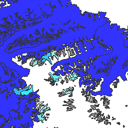
var dataset = ee.FeatureCollection('GLIMS/current');\nvar visParams = {\n palette: ['gray', 'cyan', 'blue'],\n min: 0.0,\n max: 10.0,\n opacity: 0.8,\n};\nvar image = ee.Image().float().paint(dataset, 'area');\nMap.setCenter(-35.618, 66.743, 7);\nMap.addLayer(image, visParams, 'GLIMS/current');\nMap.addLayer(dataset, null, 'for Inspector', false);\n```\n[Open in Code Editor](https://code.earthengine.google.com/?scriptPath=Examples:Datasets/GLIMS/GLIMS_current)\n\n### Visualize as a FeatureView\n\n\nA `FeatureView` is a view-only, accelerated representation of a\n`FeatureCollection`. For more details, visit the\n[`FeatureView` documentation.](/earth-engine/guides/featureview_overview)\n| **Important:** Earth Engine is a platform for petabyte-scale scientific analysis and visualization of geospatial datasets, both for public benefit and for business and government users. Earth Engine is free to use for research, education, and nonprofit use. To get started, please [register for Earth Engine access.](https://console.cloud.google.com/earth-engine)\n\n### Code Editor (JavaScript)\n\n```javascript\nvar fvLayer = ui.Map.FeatureViewLayer('GLIMS/current_FeatureView');\n\nvar visParams = {\n color: {\n property: 'area',\n mode: 'linear',\n palette: ['gray', 'cyan', 'blue'],\n min: 0.0,\n max: 10.0\n },\n opacity: 0.8,\n polygonStrokeOpacity: 0\n};\n\nfvLayer.setVisParams(visParams);\nfvLayer.setName('GLIMS/current');\n\nMap.setCenter(-35.618, 66.743, 7);\nMap.add(fvLayer);\n```\n[Open in Code Editor](https://code.earthengine.google.com/?scriptPath=Examples:Datasets/GLIMS/GLIMS_current_FeatureView) \n[GLIMS Current: Global Land Ice Measurements From Space](/earth-engine/datasets/catalog/GLIMS_current) \nGlobal Land Ice Measurements from Space (GLIMS) is an international initiative with the goal of repeatedly surveying the world's estimated 200,000 glaciers. The project seeks to create a globally comprehensive inventory of land ice, including measurements of glacier area, geometry, surface velocity, and snow line elevation. To perform these analyses, ... \nGLIMS/current, cryosphere,glacier,glims,ice,landcover,nasa,nsidc,snow,table \n1750-01-01T00:00:00Z/2023-06-07T00:00:00Z \n-90 -180 90 180 \nGoogle Earth Engine \nhttps://developers.google.com/earth-engine/datasets\n\n- [https://doi.org/10.7265/N5V98602](https://doi.org/https://www.glims.org)\n- [https://doi.org/10.7265/N5V98602](https://doi.org/https://developers.google.com/earth-engine/datasets/catalog/GLIMS_current)"]]