TerraClimate is a dataset of monthly climate and climatic water balance for
global terrestrial surfaces. It uses climatically aided interpolation,
combining high-spatial resolution climatological normals from the
WorldClim dataset, with coarser spatial
resolution, but time-varying data from
CRU Ts4.0 and the
Japanese 55-year Reanalysis (JRA55).
Conceptually, the procedure applies interpolated time-varying anomalies
from CRU Ts4.0/JRA55 to the high-spatial resolution climatology of
WorldClim to create a high-spatial resolution dataset that covers a broader
temporal record.
Temporal information is inherited from CRU Ts4.0 for most global land
surfaces for temperature, precipitation, and vapor pressure. However,
JRA55 data is used for regions where CRU data had zero climate stations
contributing (including all of Antarctica, and parts of Africa,
South America, and scattered islands). For primary climate variables of
temperature, vapor pressure, and precipitation, the University of Idaho
provides additional data on the number of stations (between 0 and 8) that
contributed to the CRU Ts4.0 data used by TerraClimate. JRA55 was used
exclusively for solar radiation and wind speeds.
TerraClimate additionally produces monthly surface water balance datasets
using a water balance model that incorporates reference evapotranspiration,
precipitation, temperature, and interpolated plant extractable soil water
capacity. A modified Thornthwaite-Mather climatic water-balance model and
extractable soil water storage capacity data was used at a 0.5° grid from
Wang-Erlandsson et al. (2016).
Data Limitations:
Long-term trends in data are inherited from parent datasets.
TerraClimate should not be used directly for independent assessments of
trends.
TerraClimate will not capture temporal variability at finer scales than
parent datasets and thus is not able to capture variability in
orographic precipitation ratios and inversions.
The water balance model is very simple and does not account for
heterogeneity in vegetation types or their physiological response to
changing environmental conditions.
Limited validation in data-sparse regions (e.g., Antarctica).
Bands
Pixel Size 4638.3 meters
Bands
Name
Units
Min
Max
Scale
Pixel Size
Description
aet
mm
0*
3140*
0.1
meters
Actual evapotranspiration, derived using a one-dimensional soil water balance model
def
mm
0*
4548*
0.1
meters
Climate water deficit, derived using a one-dimensional soil water balance model
Runoff, derived using a one-dimensional soil water balance model
soil
mm
0*
8882*
0.1
meters
Soil moisture, derived using a one-dimensional soil water balance model
srad
W/m^2
0*
5477*
0.1
meters
Downward surface shortwave radiation
swe
mm
0*
32767*
meters
Snow water equivalent, derived using a one-dimensional soil water balance model
tmmn
°C
-770*
387*
0.1
meters
Minimum temperature
tmmx
°C
-670*
576*
0.1
meters
Maximum temperature
vap
kPa
0*
14749*
0.001
meters
Vapor pressure
vpd
kPa
0*
1113*
0.01
meters
Vapor pressure deficit
vs
m/s
0*
2923*
0.01
meters
Wind-speed at 10m
* estimated min or max value
Image Properties
Image Properties
Name
Type
Description
status
STRING
'provisional' or 'permanent'
Terms of Use
Terms of Use
The data set is in the public domain as licensed under the Creative Commons
Public Domain (CC0) license.
Citations
Citations:
Abatzoglou, J.T., S.Z. Dobrowski, S.A. Parks, K.C. Hegewisch, 2018,
Terraclimate, a high-resolution global dataset of monthly climate and
climatic water balance from 1958-2015, Scientific Data 5:170191,
doi:10.1038/sdata.2017.191
TerraClimate is a dataset of monthly climate and climatic water balance for global terrestrial surfaces. It uses climatically aided interpolation, combining high-spatial resolution climatological normals from the WorldClim dataset, with coarser spatial resolution, but time-varying data from CRU Ts4.0 and the Japanese 55-year Reanalysis (JRA55). Conceptually, the procedure applies interpolated …
[null,null,[],[[["\u003cp\u003eTerraClimate provides monthly climate and climatic water balance data for global terrestrial surfaces from 1958 to 2023.\u003c/p\u003e\n"],["\u003cp\u003eThe dataset integrates high-resolution climatological normals from WorldClim with time-varying data from CRU Ts4.0 and JRA55.\u003c/p\u003e\n"],["\u003cp\u003eIt offers various climate variables, including temperature, precipitation, vapor pressure, solar radiation, and wind speeds, alongside derived water balance components like evapotranspiration, runoff, and soil moisture.\u003c/p\u003e\n"],["\u003cp\u003eTerraClimate data is available at a 4638.3 meter resolution and is provided by the University of California Merced.\u003c/p\u003e\n"],["\u003cp\u003eWhile valuable for various climate-related analyses, users should be aware of limitations regarding trend analysis, fine-scale variability, and model simplicity, especially in data-sparse regions.\u003c/p\u003e\n"]]],[],null,["# TerraClimate: Monthly Climate and Climatic Water Balance for Global Terrestrial Surfaces, University of Idaho\n\nDataset Availability\n: 1958-01-01T00:00:00Z--2024-12-01T00:00:00Z\n\nDataset Provider\n:\n\n\n [University of California Merced](http://www.climatologylab.org/terraclimate.html)\n\nCadence\n: 1 Month\n\nTags\n:\n[climate](/earth-engine/datasets/tags/climate) [drought](/earth-engine/datasets/tags/drought) [evapotranspiration](/earth-engine/datasets/tags/evapotranspiration) [geophysical](/earth-engine/datasets/tags/geophysical) [global](/earth-engine/datasets/tags/global) [merced](/earth-engine/datasets/tags/merced) [monthly](/earth-engine/datasets/tags/monthly) [palmer](/earth-engine/datasets/tags/palmer) [pdsi](/earth-engine/datasets/tags/pdsi) [precipitation](/earth-engine/datasets/tags/precipitation) [runoff](/earth-engine/datasets/tags/runoff) [temperature](/earth-engine/datasets/tags/temperature) [vapor](/earth-engine/datasets/tags/vapor) [water-vapor](/earth-engine/datasets/tags/water-vapor) [wind](/earth-engine/datasets/tags/wind) \n\n#### Description\n\nTerraClimate is a dataset of monthly climate and climatic water balance for\nglobal terrestrial surfaces. It uses climatically aided interpolation,\ncombining high-spatial resolution climatological normals from the\n[WorldClim dataset](https://www.worldclim.org/), with coarser spatial\nresolution, but time-varying data from\n[CRU Ts4.0](https://data.ceda.ac.uk/badc/cru/data/cru_ts/) and the\n[Japanese 55-year Reanalysis (JRA55)](https://jra.kishou.go.jp/JRA-55/index_en.html).\nConceptually, the procedure applies interpolated time-varying anomalies\nfrom CRU Ts4.0/JRA55 to the high-spatial resolution climatology of\nWorldClim to create a high-spatial resolution dataset that covers a broader\ntemporal record.\n\nTemporal information is inherited from CRU Ts4.0 for most global land\nsurfaces for temperature, precipitation, and vapor pressure. However,\nJRA55 data is used for regions where CRU data had zero climate stations\ncontributing (including all of Antarctica, and parts of Africa,\nSouth America, and scattered islands). For primary climate variables of\ntemperature, vapor pressure, and precipitation, the University of Idaho\nprovides additional data on the number of stations (between 0 and 8) that\ncontributed to the CRU Ts4.0 data used by TerraClimate. JRA55 was used\nexclusively for solar radiation and wind speeds.\n\nTerraClimate additionally produces monthly surface water balance datasets\nusing a water balance model that incorporates reference evapotranspiration,\nprecipitation, temperature, and interpolated plant extractable soil water\ncapacity. A modified Thornthwaite-Mather climatic water-balance model and\nextractable soil water storage capacity data was used at a 0.5° grid from\nWang-Erlandsson et al. (2016).\n\nData Limitations:\n\n1. Long-term trends in data are inherited from parent datasets.\n TerraClimate should not be used directly for independent assessments of\n trends.\n\n2. TerraClimate will not capture temporal variability at finer scales than\n parent datasets and thus is not able to capture variability in\n orographic precipitation ratios and inversions.\n\n3. The water balance model is very simple and does not account for\n heterogeneity in vegetation types or their physiological response to\n changing environmental conditions.\n\n4. Limited validation in data-sparse regions (e.g., Antarctica).\n\n### Bands\n\n\n**Pixel Size**\n\n4638.3 meters\n\n**Bands**\n\n| Name | Units | Min | Max | Scale | Pixel Size | Description |\n|--------|--------|---------|---------|-------|------------|-------------------------------------------------------------------------------------|\n| `aet` | mm | 0\\* | 3140\\* | 0.1 | meters | Actual evapotranspiration, derived using a one-dimensional soil water balance model |\n| `def` | mm | 0\\* | 4548\\* | 0.1 | meters | Climate water deficit, derived using a one-dimensional soil water balance model |\n| `pdsi` | | -4317\\* | 3418\\* | 0.01 | meters | Palmer Drought Severity Index |\n| `pet` | mm | 0\\* | 4548\\* | 0.1 | meters | Reference evapotranspiration (ASCE Penman-Montieth) |\n| `pr` | mm | 0\\* | 7245\\* | | meters | Precipitation accumulation |\n| `ro` | mm | 0\\* | 12560\\* | | meters | Runoff, derived using a one-dimensional soil water balance model |\n| `soil` | mm | 0\\* | 8882\\* | 0.1 | meters | Soil moisture, derived using a one-dimensional soil water balance model |\n| `srad` | W/m\\^2 | 0\\* | 5477\\* | 0.1 | meters | Downward surface shortwave radiation |\n| `swe` | mm | 0\\* | 32767\\* | | meters | Snow water equivalent, derived using a one-dimensional soil water balance model |\n| `tmmn` | °C | -770\\* | 387\\* | 0.1 | meters | Minimum temperature |\n| `tmmx` | °C | -670\\* | 576\\* | 0.1 | meters | Maximum temperature |\n| `vap` | kPa | 0\\* | 14749\\* | 0.001 | meters | Vapor pressure |\n| `vpd` | kPa | 0\\* | 1113\\* | 0.01 | meters | Vapor pressure deficit |\n| `vs` | m/s | 0\\* | 2923\\* | 0.01 | meters | Wind-speed at 10m |\n\n\\* estimated min or max value\n\n### Image Properties\n\n**Image Properties**\n\n| Name | Type | Description |\n|--------|--------|------------------------------|\n| status | STRING | 'provisional' or 'permanent' |\n\n### Terms of Use\n\n**Terms of Use**\n\nThe data set is in the public domain as licensed under the Creative Commons\nPublic Domain (CC0) license.\n\n### Citations\n\nCitations:\n\n- Abatzoglou, J.T., S.Z. Dobrowski, S.A. Parks, K.C. Hegewisch, 2018,\n Terraclimate, a high-resolution global dataset of monthly climate and\n climatic water balance from 1958-2015, Scientific Data 5:170191,\n [doi:10.1038/sdata.2017.191](https://doi.org/10.1038/sdata.2017.191)\n\n### Explore with Earth Engine\n\n| **Important:** Earth Engine is a platform for petabyte-scale scientific analysis and visualization of geospatial datasets, both for public benefit and for business and government users. Earth Engine is free to use for research, education, and nonprofit use. To get started, please [register for Earth Engine access.](https://console.cloud.google.com/earth-engine)\n\n### Code Editor (JavaScript)\n\n```javascript\n
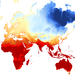
var dataset = ee.ImageCollection('IDAHO_EPSCOR/TERRACLIMATE')\n .filter(ee.Filter.date('2017-07-01', '2017-08-01'));\nvar maximumTemperature = dataset.select('tmmx');\nvar maximumTemperatureVis = {\n min: -300.0,\n max: 300.0,\n palette: [\n '1a3678', '2955bc', '5699ff', '8dbae9', 'acd1ff', 'caebff', 'e5f9ff',\n 'fdffb4', 'ffe6a2', 'ffc969', 'ffa12d', 'ff7c1f', 'ca531a', 'ff0000',\n 'ab0000'\n ],\n};\nMap.setCenter(71.72, 52.48, 3);\nMap.addLayer(maximumTemperature, maximumTemperatureVis, 'Maximum Temperature');\n```\nPython setup\n\nSee the [Python Environment](/earth-engine/guides/python_install) page for information on the Python API and using\n`geemap` for interactive development. \n\n```python\nimport ee\nimport geemap.core as geemap\n```\n\n### Colab (Python)\n\n```python\ndataset = ee.ImageCollection('IDAHO_EPSCOR/TERRACLIMATE').filter(\n ee.Filter.date('2017-07-01', '2017-08-01')\n)\nmaximum_temperature = dataset.select('tmmx')\nmaximum_temperature_vis = {\n 'min': -300.0,\n 'max': 300.0,\n 'palette': [\n '1a3678',\n '2955bc',\n '5699ff',\n '8dbae9',\n 'acd1ff',\n 'caebff',\n 'e5f9ff',\n 'fdffb4',\n 'ffe6a2',\n 'ffc969',\n 'ffa12d',\n 'ff7c1f',\n 'ca531a',\n 'ff0000',\n 'ab0000',\n ],\n}\n\nm = geemap.Map()\nm.set_center(71.72, 52.48, 3)\nm.add_layer(\n maximum_temperature, maximum_temperature_vis, 'Maximum Temperature'\n)\nm\n```\n[Open in Code Editor](https://code.earthengine.google.com/?scriptPath=Examples:Datasets/IDAHO_EPSCOR/IDAHO_EPSCOR_TERRACLIMATE) \n[TerraClimate: Monthly Climate and Climatic Water Balance for Global Terrestrial Surfaces, University of Idaho](/earth-engine/datasets/catalog/IDAHO_EPSCOR_TERRACLIMATE) \nTerraClimate is a dataset of monthly climate and climatic water balance for global terrestrial surfaces. It uses climatically aided interpolation, combining high-spatial resolution climatological normals from the WorldClim dataset, with coarser spatial resolution, but time-varying data from CRU Ts4.0 and the Japanese 55-year Reanalysis (JRA55). Conceptually, the procedure applies interpolated ... \nIDAHO_EPSCOR/TERRACLIMATE, climate,drought,evapotranspiration,geophysical,global,merced,monthly,palmer,pdsi,precipitation,runoff,temperature,vapor,water-vapor,wind \n1958-01-01T00:00:00Z/2024-12-01T00:00:00Z \n-90 -180 90 180 \nGoogle Earth Engine \nhttps://developers.google.com/earth-engine/datasets\n\n- [](https://doi.org/http://www.climatologylab.org/terraclimate.html)\n- [](https://doi.org/https://developers.google.com/earth-engine/datasets/catalog/IDAHO_EPSCOR_TERRACLIMATE)"]]