- Dostępność zbioru danych
- 2009-01-01T00:00:00Z–2021-01-01T00:00:00Z
- Dostawca zbioru danych
- IGN
- Tagi
Opis
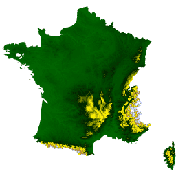
Zbiór danych RGE ALTI zawiera numeryczny model terenu (NMT) Francji o rozmiarze piksela 1 m. Została utworzona na podstawie pomiarów uzyskanych za pomocą lotniczego lidaru lub korelacji zdjęć lotniczych.
Technologia lidar została zastosowana na obszarach zagrożonych powodzią, wybrzeżach i dużych lasach. Dokładność pionowa DEM na tych obszarach wynosi od 0,2 m do 0,5 m. Radaru używano na obszarach górskich (Alpy, Pireneje, Sewenny, Korsyka). Uwaga: na obszarach o stromych zboczach średnia dokładność pionowa wynosi około 7 m.
Dokładność tych pól została sprawdzona na podstawie różnych źródeł: sieci drogowych i hydrograficznych BD TOPO, terminali geodezyjnych i punktów obliczonych na ziemi.
Na pozostałym obszarze stosowane są techniki korelacji zdjęć lotniczych. W przypadku niektórych stref objętych korelacją pomiary naziemne są niedostępne na dużych obszarach z powodu obecności roślinności (np. obszarów zalesionych). Do wypełnienia tych luk wykorzystywane są dane altimetryczne z lat 1987–2001 (BD Alti). Dokładność pionowa modelu DEM na tych obszarach wynosi od 0,5 m do 0,7 m.
Obecnie kolekcja zawiera 1 obraz IGN/RGE_ALTI/1M/2_0/FXX przedstawiający Francję metropolitalną.
Ten zbiór danych został przygotowany i zaimportowany przy wsparciu Guillaume’a Attarda i Juliena Bardonneta (AGEOCE). Proces przygotowania jest opisany tutaj.
Zobacz też przewodnik użytkownika.
Pasma
Pasma
Rozmiar piksela: 1 metr (wszystkie pasma)
| Nazwa | Jednostki | Min. | Maks. | Rozmiar piksela | Opis |
|---|---|---|---|---|---|
MNT |
m | -40* | 4810* | 1 metr | Wysokość terenu w metrach. |
SRC |
1 metr | Główne źródło danych używanych do obliczania wysokości węzła. Zobacz dodatek B na stronie 26 w przewodniku użytkownika. |
|||
DST |
m | 0 | 255 | 1 metr | Odległość w metrach między węzłem a najbliższym punktem używanym do obliczania jego wysokości. |
Warunki korzystania z usługi
Warunki korzystania z usługi
Cytaty
IGN (2021). RGE ALTI 1m [Data set]. Dostęp: 1 lipca 2022 r. na stronie IGN
Odkrywaj za pomocą Earth Engine
Edytor kodu (JavaScript)
var dataset = ee.Image('IGN/RGE_ALTI/1M/2_0/FXX');
var elevation = dataset.select('MNT');

var elevationVis = {
  min: 0,
  max: 1000,
  palette: ['006600', '002200', 'fff700', 'ab7634', 'c4d0ff', 'ffffff']
};

Map.addLayer(elevation, elevationVis, 'Elevation');
Map.setCenter(3, 47, 5);