- Disponibilidad del conjunto de datos
- 2017-01-01T00:00:00Z–2021-01-01T00:00:00Z
- Proveedor de conjuntos de datos
- JAXA EORC
- Etiquetas
Descripción
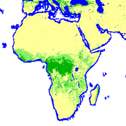
El mapa global de bosque/no bosque (FNF) se genera clasificando la imagen SAR (coeficiente de retrodispersión) en el mosaico SAR global de PALSAR-2/PALSAR con una resolución de 25 m, de modo que los píxeles de retrodispersión alta y baja se asignen como "bosque" y "no bosque", respectivamente. Aquí, "bosque" se define como el bosque natural con una superficie superior a 0.5 ha y una cubierta forestal superior al 10%. Esta definición es la misma que la de la Organización de las Naciones Unidas para la Alimentación y la Agricultura (FAO). Dado que la retrodispersión del radar del bosque depende de la región (zona climática), la clasificación de bosque/no bosque se realiza con un umbral de retrodispersión que depende de la región. La precisión de la clasificación se verifica con fotos in situ y con imágenes satelitales ópticas de alta resolución.
Información detallada:
Atención:
- Los valores de dispersión pueden variar significativamente de una ruta a otra en las áreas forestales de latitudes altas. Esto se debe al cambio en la intensidad de la retrodispersión causada por los árboles congelados en invierno. Ten en cuenta que esto puede afectar la clasificación de bosque/no bosque.
Bandas
Tamaño de píxel
25 metros
Bandas
| Nombre | Mín. | Máx. | Tamaño de los píxeles | Descripción |
|---|---|---|---|---|
fnf |
1 | 4 | metros | Clasificación de la cobertura terrestre en forestal y no forestal |
Tabla de clases de FNF
| Valor | Color | Descripción |
|---|---|---|
| 1 | #00b200 | Bosque frondoso |
| 2 | #83ef62 | Bosque no denso |
| 3 | #ffff99 | No bosque |
| 4 | #0000ff | Agua |
Condiciones de Uso
Condiciones de Uso
JAXA conserva la propiedad del conjunto de datos y no puede garantizar ningún problema causado o posiblemente causado por el uso de los conjuntos de datos. Cualquier persona que desee publicar resultados con los conjuntos de datos debe reconocer claramente la propiedad de los datos en la publicación.
Citas
Masanobu Shimada, Takuya Itoh, Takeshi Motooka, Manabu Watanabe, Shiraishi Tomohiro, Rajesh Thapa y Richard Lucas, "New Global Forest/Non-forest Maps from ALOS PALSAR Data (2007-2010)", Remote Sensing of Environment, 155, págs. 13-31, diciembre de 2014. doi:10.1016/j.rse.2014.04.014.
Explora con Earth Engine
Editor de código (JavaScript)
var dataset = ee.ImageCollection('JAXA/ALOS/PALSAR/YEARLY/FNF4')
                  .filterDate('2018-01-01', '2018-12-31');
var forestNonForest = dataset.select('fnf');
var forestNonForestVis = {
  min: 1,
  max: 4,
  palette: ['00b200','83ef62','ffff99','0000ff'],
};
Map.setCenter(136.85, 37.37, 4);
Map.addLayer(forestNonForest, forestNonForestVis, 'Forest/Non-Forest');