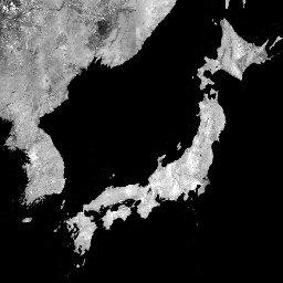
গ্লোবাল 25m PALSAR/PALSAR-2 মোজাইক হল PALSAR/PALSAR-2 থেকে SAR চিত্রের মোজাইকিং স্ট্রিপ দ্বারা তৈরি একটি নির্বিঘ্ন গ্লোবাল SAR ইমেজ। প্রতি বছর এবং অবস্থানের জন্য, স্ট্রিপ ডেটাগুলি সেই সময়কালে উপলব্ধ ব্রাউজ মোজাইকগুলির ভিজ্যুয়াল পরিদর্শনের মাধ্যমে নির্বাচন করা হয়েছিল, যেগুলি পৃষ্ঠের আর্দ্রতার জন্য ন্যূনতম প্রতিক্রিয়া দেখায় যা অগ্রাধিকারমূলকভাবে ব্যবহৃত হয়। যেসব ক্ষেত্রে প্রাপ্যতা সীমিত ছিল (উদাহরণস্বরূপ, নির্দিষ্ট জরুরী অবস্থার সময় পর্যবেক্ষণের প্রয়োজনীয়তার কারণে), 2006 সাল সহ, আগে বা পরের বছর থেকে ডেটা অগত্যা নির্বাচন করা হয়েছিল। শিমাদা এট আল। 2014
ALOS এবং ALOS-2 টেম্পোরাল কভারেজের মধ্যে ব্যবধানের কারণে 2011-2014 এর জন্য কোন তথ্য নেই।
90m SRTM ডিজিটাল এলিভেশন মডেল ব্যবহার করে SAR চিত্রগুলি অর্থো-সংশোধন করা হয়েছে এবং ঢাল সংশোধন করা হয়েছে৷ একটি ডিস্ট্রিপিং প্রক্রিয়া (শিমাদা এবং ইসোগুচি, 2002, 2010) প্রতিবেশী স্ট্রিপগুলির মধ্যে তীব্রতার পার্থক্যকে সমান করার জন্য প্রয়োগ করা হয়েছিল, যা মূলত পৃষ্ঠের আর্দ্রতার অবস্থার মৌসুমী এবং দৈনন্দিন পার্থক্যের কারণে ঘটে।
পোলারাইজেশন ডেটা 16-বিট ডিজিটাল নম্বর (DN) হিসাবে সংরক্ষণ করা হয়। নিম্নলিখিত সমীকরণ ব্যবহার করে ডিএন মানগুলিকে ডেসিবেল ইউনিটে (ডিবি) গামা নট মানগুলিতে রূপান্তর করা যেতে পারে:
γ₀ = 10log₁₀(DN²) - 83.0 dB
মনোযোগ:
ব্যাকস্ক্যাটার মানগুলি উচ্চ অক্ষাংশের বন অঞ্চলে পাথ থেকে পাথে উল্লেখযোগ্যভাবে পরিবর্তিত হতে পারে। এটি শীতকালে হিমায়িত গাছের কারণে ব্যাকস্ক্যাটারিং তীব্রতার পরিবর্তনের কারণে।
পর্যবেক্ষণের তারিখ (1 জানুয়ারী, 1970 সাল থেকে দিন)।
qa
মিটার
তথ্য প্রক্রিয়াকরণ.
qa ক্লাস টেবিল
মান
রঙ
বর্ণনা
0
#000000
কোন তথ্য নেই
50
#0000ff
মহাসাগর এবং জল
100
#aaaa00
রাডার লেওভার
150
#005555
রাডার ছায়া
255
#aa9988
জমি
ব্যবহারের শর্তাবলী
ব্যবহারের শর্তাবলী
JAXA ডেটাসেটের মালিকানা ধরে রাখে এবং ডেটাসেটগুলি ব্যবহার করার কারণে সৃষ্ট বা সম্ভবত সৃষ্ট কোনও সমস্যার গ্যারান্টি দিতে পারে না। ডেটাসেট ব্যবহার করে যে কোনো ফলাফল প্রকাশ করতে ইচ্ছুক যে কেউ প্রকাশনায় ডেটার মালিকানা স্পষ্টভাবে স্বীকার করতে হবে।
উদ্ধৃতি
উদ্ধৃতি:
Masanobu Shimada, Takuya Itoh, Takeshi Motooka, Manabu Watanabe, Shiraishi Tomohiro, Rajesh Thapa, and Richard Lucas, "New Global Forest/Non-forest Maps from ALOS PALSAR Data (2007-2010)", Remote Sensing of Environment,-5135 December,513. doi:10.1016/j.rse.2014.04.014.
2015-2021-এর ডেটা সহ এই ডেটাসেটের একটি নতুন সংস্করণ JAXA/ALOS/PALSAR/YEARLY/SAR_EPOCH-এ পাওয়া যাবে গ্লোবাল 25m PALSAR/PALSAR-2 মোজাইক হল একটি বিজোড় গ্লোবাল SAR ইমেজ যা PALSAR2PALS-এর SAR ছবির মোজাইকিং স্ট্রিপ দ্বারা তৈরি করা হয়েছে৷ প্রতি বছর এবং অবস্থানের জন্য, স্ট্রিপ ডেটা চাক্ষুষ পরিদর্শনের মাধ্যমে নির্বাচন করা হয়েছিল …
[null,null,[],[[["\u003cp\u003eThe JAXA/ALOS/PALSAR/YEARLY/SAR dataset provides a global 25m resolution mosaic of PALSAR/PALSAR-2 SAR imagery from 2007-2020, excluding 2011-2014.\u003c/p\u003e\n"],["\u003cp\u003eThe dataset includes HH and HV polarization backscattering coefficients, local incidence angle, observation date, and processing information bands.\u003c/p\u003e\n"],["\u003cp\u003eImagery was orthorectified, slope corrected, and destriped to minimize intensity differences between neighboring strips.\u003c/p\u003e\n"],["\u003cp\u003eDN values can be converted to gamma naught values (dB) using the equation: γ₀ = 10log₁₀(DN²) - 83.0 dB.\u003c/p\u003e\n"],["\u003cp\u003eBackscatter values may vary over high latitude forests due to seasonal changes in tree freezing.\u003c/p\u003e\n"]]],[],null,["# Global PALSAR-2/PALSAR Yearly Mosaic, version 1\n\nDataset Availability\n: 2007-01-01T00:00:00Z--2020-01-01T00:00:00Z\n\nDataset Provider\n:\n\n\n [JAXA EORC](https://www.eorc.jaxa.jp/ALOS/en/dataset/fnf_e.htm)\n\nTags\n:\n[alos](/earth-engine/datasets/tags/alos) [alos2](/earth-engine/datasets/tags/alos2) [eroc](/earth-engine/datasets/tags/eroc) [jaxa](/earth-engine/datasets/tags/jaxa) [palsar](/earth-engine/datasets/tags/palsar) [palsar2](/earth-engine/datasets/tags/palsar2) [sar](/earth-engine/datasets/tags/sar) [satellite-imagery](/earth-engine/datasets/tags/satellite-imagery) \n\n#### Description\n\nA newer version of this dataset with data for 2015-2021 can be found in\n[JAXA/ALOS/PALSAR/YEARLY/SAR_EPOCH](/earth-engine/datasets/catalog/JAXA_ALOS_PALSAR_YEARLY_SAR_EPOCH)\n\nThe global 25m PALSAR/PALSAR-2 mosaic is a seamless global\nSAR image created by mosaicking strips of SAR imagery\nfrom PALSAR/PALSAR-2. For each year and location,\nthe strip data were selected through visual inspection of the\nbrowse mosaics available over the period, with those showing minimum\nresponse to surface moisture preferentially used. In cases\nwhere the availability was limited (e.g., because of the requirement\nfor observations during specific emergencies), data were necessarily\nselected from the year before or after, including from 2006.\n[Shimada et al. 2014](https://doi.org/10.1016/j.rse.2014.04.014)\n\nThere is no data for 2011-2014 due to the gap between ALOS and ALOS-2\ntemporal coverage.\n\nThe SAR imagery was ortho-rectificatied and slope corrected\nusing the 90m SRTM Digital Elevation Model.\nA destriping process (Shimada \\& Isoguchi, 2002, 2010) was applied\nto equalize the intensity differences between neighboring strips,\noccurring largely due to seasonal and daily differences\nin surface moisture conditions.\n\nPolarization data are stored as 16-bit digital numbers (DN).\nThe DN values can be converted to gamma naught values\nin decibel unit (dB) using the following equation:\n\n- γ₀ = 10log₁₀(DN²) - 83.0 dB\n\nAttention:\n\n- Backscatter values may vary significantly from path to path over high latitude forest areas. This is due to the change of backscattering intensity caused by freezing trees in winter.\n\nMore information is available in the provider's\n[Dataset Description](https://www.eorc.jaxa.jp/ALOS/en/palsar_fnf/DatasetDescription_PALSAR2_Mosaic_FNF_revH.pdf).\n\n### Bands\n\n\n**Pixel Size**\n\n25 meters\n\n**Bands**\n\n| Name | Units | Pixel Size | Description |\n|---------|-------|------------|--------------------------------------------------------|\n| `HH` | | meters | HH polarization backscattering coefficient, 16-bit DN. |\n| `HV` | | meters | HV polarization backscattering coefficient, 16-bit DN. |\n| `angle` | deg | meters | Local incidence angle. |\n| `date` | | meters | Observation date (days since Jan 1, 1970). |\n| `qa` | | meters | Processing information. |\n\n**qa Class Table**\n\n| Value | Color | Description |\n|-------|---------|-----------------|\n| 0 | #000000 | No data |\n| 50 | #0000ff | Ocean and water |\n| 100 | #aaaa00 | Radar layover |\n| 150 | #005555 | Radar shadowing |\n| 255 | #aa9988 | Land |\n\n### Terms of Use\n\n**Terms of Use**\n\nJAXA retains ownership of the dataset and cannot guarantee\nany problem caused by or possibly caused by using the datasets.\nAnyone wishing to publish any results using the datasets should\nclearly acknowledge the ownership of the data in the publication.\n\n### Citations\n\nCitations:\n\n- Masanobu Shimada, Takuya Itoh, Takeshi Motooka, Manabu Watanabe,\n Shiraishi Tomohiro, Rajesh Thapa, and Richard Lucas, \"New Global\n Forest/Non-forest Maps from ALOS PALSAR Data (2007-2010)\", Remote Sensing\n of Environment, 155, pp. 13-31, December 2014.\n [doi:10.1016/j.rse.2014.04.014.](https://doi.org/10.1016/j.rse.2014.04.014)\n\n### Explore with Earth Engine\n\n| **Important:** Earth Engine is a platform for petabyte-scale scientific analysis and visualization of geospatial datasets, both for public benefit and for business and government users. Earth Engine is free to use for research, education, and nonprofit use. To get started, please [register for Earth Engine access.](https://console.cloud.google.com/earth-engine)\n\n### Code Editor (JavaScript)\n\n```javascript\nvar dataset = ee.ImageCollection('JAXA/ALOS/PALSAR/YEARLY/SAR')\n .filter(ee.Filter.date('2017-01-01', '2018-01-01'));\nvar sarHh = dataset.select('HH');\nvar sarHhVis = {\n min: 0.0,\n max: 10000.0,\n};\nMap.setCenter(136.85, 37.37, 4);\nMap.addLayer(sarHh, sarHhVis, 'SAR HH');\n```\n[Open in Code Editor](https://code.earthengine.google.com/?scriptPath=Examples:Datasets/JAXA/JAXA_ALOS_PALSAR_YEARLY_SAR) \n[Global PALSAR-2/PALSAR Yearly Mosaic, version 1](/earth-engine/datasets/catalog/JAXA_ALOS_PALSAR_YEARLY_SAR) \nA newer version of this dataset with data for 2015-2021 can be found in JAXA/ALOS/PALSAR/YEARLY/SAR_EPOCH The global 25m PALSAR/PALSAR-2 mosaic is a seamless global SAR image created by mosaicking strips of SAR imagery from PALSAR/PALSAR-2. For each year and location, the strip data were selected through visual inspection of the ... \nJAXA/ALOS/PALSAR/YEARLY/SAR, alos,alos2,eroc,jaxa,palsar,palsar2,sar,satellite-imagery \n2007-01-01T00:00:00Z/2020-01-01T00:00:00Z \n-90 -180 90 180 \nGoogle Earth Engine \nhttps://developers.google.com/earth-engine/datasets\n\n- [](https://doi.org/https://www.eorc.jaxa.jp/ALOS/en/dataset/fnf_e.htm)\n- [](https://doi.org/https://developers.google.com/earth-engine/datasets/catalog/JAXA_ALOS_PALSAR_YEARLY_SAR)"]]