- Dostępność zbioru danych
- 2020-12-31T00:00:00Z–2020-12-31T00:00:01Z
- Dostawca zbioru danych
- Wspólne Centrum Badawcze, Komisja Europejska
- Cykl
- 1 rok
- Tagi
Opis
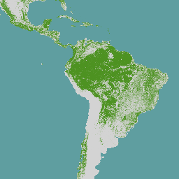
Globalna mapa pokrywy leśnej przedstawia przestrzenną reprezentację obecności i braku lasów w 2020 roku w rozdzielczości przestrzennej 10 m.
Rok 2020 to data graniczna rozporządzenia Unii Europejskiej „w sprawie udostępniania na rynku Unii i wywozu z Unii niektórych towarów i produktów związanych z wylesianiem i degradacją lasów” (EUDR, rozporządzenie (UE) 2023/1115). W kontekście rozporządzenia UE w sprawie przeciwdziałania wylesianiu globalna mapa pokrywy leśnej może być używana jako niewiążące prawnie, niewyłączne i nieobowiązkowe źródło informacji. Więcej informacji o mapie i jej zastosowaniu znajdziesz w Obserwatorium UE ds. wylesiania i degradacji lasów (EUFO), a w szczególności w sekcji z odpowiedziami na najczęstsze pytania.
Las oznacza obszar o powierzchni ponad 0,5 ha, na którym rosną drzewa o wysokości powyżej 5 m i pokrywie koron powyżej 10%, lub drzewa, które mogą osiągnąć te wartości w danym miejscu, z wyłączeniem obszarów, które są wykorzystywane głównie pod uprawy rolne lub jako tereny miejskie. Użytkowanie rolnicze oznacza użytkowanie gruntów na potrzeby rolnictwa, w tym pod plantacje rolnicze (tj. drzewostany w rolniczych systemach produkcji, takie jak sady, plantacje palm olejowych, gaje oliwne i systemy rolno-leśne) i odłogowane obszary rolnicze, oraz na potrzeby hodowli zwierząt gospodarskich. Wszystkie plantacje odpowiednich towarów innych niż drewno, czyli bydła, kakao, kawy, palmy olejowej, kauczuku i soi, są wyłączone z definicji lasu.
Globalna mapa pokrywy leśnej powstała w wyniku połączenia istniejących globalnych warstw przestrzennych (obejmujących cały świat), np. dotyczących pokrycia terenu, użytkowania gruntów i wysokości drzew. Mapa ma przedstawiać stan pokrywy leśnej do 31 grudnia 2020 r. Globalna mapa pokrycia terenu z projektu ESA World Cover służy jako warstwa bazowa do określania zasięgu pokrycia drzewami w 2020 r. w rozdzielczości przestrzennej 10 m. W 2024 r. globalna mapa pokrywy leśnej z 2020 r. została ulepszona dzięki uwzględnieniu opinii użytkowników oraz nowych lub zmienionych warstw danych przestrzennych.
Obecnie lepiej uwzględnia lasy, w których nie przeprowadzono inwentaryzacji w okresie objętym analizą, lasy tropikalne o niskiej gęstości i wtórne lasy tropikalne, które odrosły w ciągu co najmniej 5 lat. Dodatkowo kryteria wykluczenia zostały ulepszone, aby skuteczniej wykluczać drzewa na obszarach miejskich, w kopalniach, na terenach podmokłych, na obszarach z rolnictwem przenośnym i na plantacjach drzew. Osiągamy to dzięki wykorzystaniu wielu globalnych map wysokości koron drzew, obszarów upraw i map konkretnych upraw, aby dokładniej odróżniać lasy od drzew wykorzystywanych w rolnictwie.
Aby uzyskać bezpośredni dostęp do metadanych, zapoznaj się z katalogiem danych JRC (JRC 2024). Raport techniczny (Bourgoin i in. 2025) opisuje podejście do mapowania w przypadku drugiej wersji. Ocena dokładności mapy globalnego pokrycia lasami jest opisana w osobnym raporcie.
Globalna mapa pokrywy leśnej może zostać zmieniona, jeśli zostaną udostępnione nowe informacje, dodatkowe warstwy danych na dużą skalę lub zmienione globalne warstwy danych przestrzennych za 2020 r.
Listę znanych problemów znajdziesz na tej stronie.
Pasma
Rozmiar piksela
10 metrów
Pasma
| Nazwa | Rozmiar piksela | Opis |
|---|---|---|
Map |
metry | Globalne pokrycie lasami w 2020 r. |
Tabela klas mapy
| Wartość | Kolor | Opis |
|---|---|---|
| 1 | #4d9221 | Las |
Warunki korzystania z usługi
Warunki korzystania z usługi
Dane mogą być używane przez każdego, w dowolnym miejscu i czasie, bez pozwolenia, licencji lub opłaty licencyjnej. Wymagane jest podanie atrybucji za pomocą zalecanego cytowania.
Cytaty
Bourgoin, Clement; Verhegghen, Astrid; Degreve, Lucas; Ameztoy, Iban; Carboni, Silvia; Colditz, Rene; Achard, Frederic (2024): Global map of forest cover 2020 - version 2. Komisja Europejska, Wspólne Centrum Badawcze (JRC) [zbiór danych] PID: http://data.europa.eu/89h/e554d6fb-6340-45d5-9309-332337e5bc26
Bourgoin, C., Verhegghen, A., Carboni, S., Degreve, L., Ameztoy Aramendi, I., Ceccherini, G., Colditz, R. i Achard, F., Global Forest Maps for the Year 2020 to Support the EU Regulation on Deforestation-free Supply Chains, Publications Office of the European Union, Luksemburg, 2025 r., https://data.europa.eu/doi/10.2760/1975879, JRC141702.
Colditz, R., Verhegghen, A., Carboni, S., Bourgoin, C., Duerauer, M., Mansuy, N., De Marzo, T., Beuchle, R., Janouskova, K., Armada Bras, T., Desclée, B., Orlowski, K., Mutendeudzi, M., Ameztoy Aramendi, I., Fritz, S., Lesiv, M., Oom, D., Carreiras, J., San-Miguel, J., Herold, M., Berger, K., Nepomshina, O., Gond, V., Defourny, P., Lamarche, C., Bos, A., Collet, T., Delhez, B., Mollicone, D., Bastin, J.-F., De Haulleville, T., Brink, A., Lupi, A., Tsendbazar, N.E., Stehman, S.V. i Achard, F., Accuracy Assessment of the Global Forest Cover Map for the Year 2020: Assessment Pro-tocol and Analysis, Publications Office of the European Union, Luksemburg, 2025, https://data.europa.eu/doi/10.2760/7632707, JRC141231.
Odkrywanie za pomocą Earth Engine
Edytor kodu (JavaScript)
var image2020 = ee.ImageCollection('JRC/GFC2020/V2').mosaic();

var visualization = {
  bands: ['Map'],
  palette: ['4D9221']};

Map.setCenter(0.0, 0.0, 2);

Map.addLayer(image2020, visualization, 'EC JRC Global forest cover 2020 – V2');