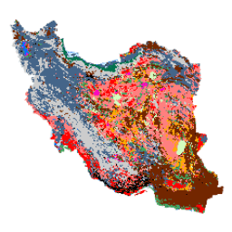
Ogólnokrajowa mapa pokrycia terenu w Iranie została wygenerowana przez przetworzenie zdjęć z satelity Sentinel na platformie Google Earth Engine Cloud. W tym celu przetworzono ponad 2500 zdjęć z satelity Sentinel-1 i ponad 11 000 zdjęć z satelity Sentinel-2, aby utworzyć jeden zbiór danych mozaikowych za rok 2017. Następnie na podstawie dużej liczby próbek referencyjnych dla 13 klas wytrenowano metodę klasyfikacji opartą na obiektach Random Forest, aby wygenerować mapę pokrycia terenu w Iranie.
Pasma
Pasma
Nazwa
Rozmiar piksela
Opis
classification
10 metrów
Klasyfikacja
Tabela klasyfikacji
Wartość
Kolor
Opis
1
#000000
Region miejski
2
#006eff
Woda
3
#41a661
Bagna
4
#ff7f7f
Kalut (yardang)
5
#bee8ff
Marshland
6
#ff00c5
Salty Land
7
#ff0000
Clay
8
#00734c
Las
9
#732600
Outcrop
10
#ffaa00
Niepokryta równina
11
#d3ffbe
Piasek
12
#446589
Grunty rolne
13
#cccccc
Range Land
Warunki korzystania z usługi
Praca „Iran Land Cover Map
v1 13-class (2017)” autorstwa Arsalana Ghorbaniana, Mohammada Kakooei, Meisama Amaniego,
Sahela Mahdaviego, Alego Mohammadzadeha i Mahdiego Hasanlou jest objęta licencją Creative
Commons Attribution 4.0 International (CC BY 4.0)
Cytaty
Cytowania:
Ghorbanian, A., Kakooei, M., Amani, M., Mahdavi, S., Mohammadzadeh, A., &
Hasanlou, M. (2020). Ulepszona mapa pokrycia terenu Iranu z wykorzystaniem zdjęć z satelity Sentinel w Google Earth Engine oraz nowego automatycznego przepływu pracy do klasyfikacji pokrycia terenu z użyciem przeniesionych próbek treningowych. ISPRS Journal of
Photogrammetry and Remote Sensing, 167, 276-288.
doi:10.1016/j.isprsjprs.2020.07.013
Mapa pokrycia terenu w Iranie została wygenerowana przez przetworzenie zdjęć z satelity Sentinel na platformie Google Earth Engine Cloud. W tym celu przetworzono ponad 2500 zdjęć z satelity Sentinel-1 i ponad 11 000 zdjęć z satelity Sentinel-2, aby utworzyć jeden zestaw danych mozaikowych za rok 2017. Następnie wytrenowano metodę klasyfikacji opartą na obiektach z użyciem algorytmu Random Forest…
[null,null,[],[[["\u003cp\u003eThis dataset provides a 13-class land cover map of Iran for the year 2017, created using Sentinel-1 and Sentinel-2 imagery processed in Google Earth Engine.\u003c/p\u003e\n"],["\u003cp\u003eThe classification was performed using an object-based Random Forest method trained with a large number of reference samples.\u003c/p\u003e\n"],["\u003cp\u003eThe dataset is available at a 10-meter resolution and includes classes like urban, water, wetland, forest, and farmland.\u003c/p\u003e\n"],["\u003cp\u003eThe data is provided by the K.N. Toosi University of Technology LiDAR Lab and is licensed under the Creative Commons Attribution 4.0 International License (CC BY 4.0).\u003c/p\u003e\n"],["\u003cp\u003eUsers can access and analyze this dataset through the Google Earth Engine platform.\u003c/p\u003e\n"]]],["The K. N. Toosi University of Technology LiDAR Lab produced a 13-class land cover map of Iran for 2017, using over 13,500 Sentinel-1 and Sentinel-2 images processed in Google Earth Engine. An object-based Random Forest classification method was applied, with reference samples to identify categories like urban, water, forest, and more. The map is accessible via Earth Engine with the snippet `ee.Image(\"KNTU/LiDARLab/IranLandCover/V1\")`, under a CC BY 4.0 license.\n"],null,["# Iran Land Cover Map v1 13-class (2017)\n\nDataset Availability\n: 2017-01-01T00:00:00Z--2018-01-01T00:00:00Z\n\nDataset Provider\n:\n\n\n [K. N. Toosi University of Technology LiDAR Lab](https://en.kntu.ac.ir/laser-scanners-laboratory/)\n\nTags\n:\n [landcover](/earth-engine/datasets/tags/landcover) [landuse-landcover](/earth-engine/datasets/tags/landuse-landcover) \n iran \nkntu \n\n#### Description\n\nThe Iran-wide land cover map was generated by processing Sentinel imagery\nwithin the Google Earth Engine Cloud platform. For this purpose, over 2,500\nSentinel-1 and over 11,000 Sentinel-2 images were processed to produce a single\nmosaic dataset for the year 2017. Then, an object-based Random Forest\nclassification method was trained by a large number of reference samples for 13\nclasses to generate the Iran-wide land cover map.\n\n### Bands\n\n**Bands**\n\n| Name | Pixel Size | Description |\n|------------------|------------|----------------|\n| `classification` | 10 meters | Classification |\n\n**classification Class Table**\n\n| Value | Color | Description |\n|-------|---------|-----------------|\n| 1 | #000000 | Urban |\n| 2 | #006eff | Water |\n| 3 | #41a661 | Wetland |\n| 4 | #ff7f7f | Kalut (yardang) |\n| 5 | #bee8ff | Marshland |\n| 6 | #ff00c5 | Salty Land |\n| 7 | #ff0000 | Clay |\n| 8 | #00734c | Forest |\n| 9 | #732600 | Outcrop |\n| 10 | #ffaa00 | Uncovered Plain |\n| 11 | #d3ffbe | Sand |\n| 12 | #446589 | Farm Land |\n| 13 | #cccccc | Range Land |\n\n### Terms of Use\n\n**Terms of Use**\n\nThis work \"Iran Land Cover Map\nv1 13-class (2017)\" by Arsalan Ghorbanian, Mohammad Kakooei, Meisam Amani,\nSahel Mahdavi, Ali Mohammadzadeh, Mahdi Hasanlou is licensed under the [Creative\nCommons Attribution 4.0 International License (CC BY 4.0)](https://creativecommons.org/licenses/by/4.0/)\n\n### Citations\n\nCitations:\n\n- Ghorbanian, A., Kakooei, M., Amani, M., Mahdavi, S., Mohammadzadeh, A., \\&\n Hasanlou, M. (2020). Improved land cover map of Iran using Sentinel imagery\n within Google Earth Engine and a novel automatic workflow for land cover\n classification using migrated training samples. ISPRS Journal of\n Photogrammetry and Remote Sensing, 167, 276-288.\n [doi:10.1016/j.isprsjprs.2020.07.013](https://doi.org/10.1016/j.isprsjprs.2020.07.013)\n\n### Explore with Earth Engine\n\n| **Important:** Earth Engine is a platform for petabyte-scale scientific analysis and visualization of geospatial datasets, both for public benefit and for business and government users. Earth Engine is free to use for research, education, and nonprofit use. To get started, please [register for Earth Engine access.](https://console.cloud.google.com/earth-engine)\n\n### Code Editor (JavaScript)\n\n```javascript\nvar dataset = ee.Image('KNTU/LiDARLab/IranLandCover/V1');\n\nvar visualization = {\n bands: ['classification']\n};\n\nMap.setCenter(54.0, 33.0, 5);\n\nMap.addLayer(dataset, visualization, 'Classification');\n```\n[Open in Code Editor](https://code.earthengine.google.com/?scriptPath=Examples:Datasets/KNTU/KNTU_LiDARLab_IranLandCover_V1) \n[Iran Land Cover Map v1 13-class (2017)](/earth-engine/datasets/catalog/KNTU_LiDARLab_IranLandCover_V1) \nThe Iran-wide land cover map was generated by processing Sentinel imagery within the Google Earth Engine Cloud platform. For this purpose, over 2,500 Sentinel-1 and over 11,000 Sentinel-2 images were processed to produce a single mosaic dataset for the year 2017. Then, an object-based Random Forest classification method was trained ... \nKNTU/LiDARLab/IranLandCover/V1, landcover,landuse-landcover \n2017-01-01T00:00:00Z/2018-01-01T00:00:00Z \n24.62 43.46 39.95 65.58 \nGoogle Earth Engine \nhttps://developers.google.com/earth-engine/datasets\n\n- [](https://doi.org/https://en.kntu.ac.ir/laser-scanners-laboratory/)\n- [](https://doi.org/https://developers.google.com/earth-engine/datasets/catalog/KNTU_LiDARLab_IranLandCover_V1)"]]