- Доступность набора данных
- 1972-07-25T00:00:00Z–1983-02-20T00:00:00Z
- Производитель наборов данных
- Геологическая служба США
- Теги
Описание
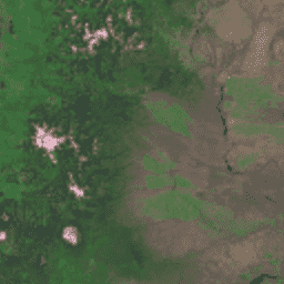
Глобальная наземная съемка (GLS) 1975 года — это глобальная коллекция изображений, полученных с помощью мультиспектрального сканера Landsat (MSS). Большинство снимков были сделаны спутниками Landsat 1-3 в 1972-1983 годах. Несколько пробелов в данных Landsat 1-3 были заполнены снимками, полученными спутниками Landsat 4-5 в 1982-1987 годах. Эти данные содержат 4 спектральных диапазона: зеленый, красный, ближний инфракрасный (NIR) и коротковолновый инфракрасный (SWIR) диапазоны. В типичном представлении в ложных цветах изображения выглядят красными, потому что ближний инфракрасный диапазон, отображаемый красным цветом, выделяет растительность.
Группы
Группы
Размер пикселя: 60 метров (все диапазоны)
| Имя | Размер пикселя | Длина волны | Описание |
|---|---|---|---|
10 | 60 метров | 500-600 нм | Зеленый |
20 | 60 метров | 600-700 нм | Красный |
30 | 60 метров | 700-800 нм | Ближний инфракрасный диапазон |
40 | 60 метров | 800-1100 нм | Коротковолновое инфракрасное излучение |
Условия эксплуатации
Условия эксплуатации
Данные Landsat создаются на федеральном уровне и, следовательно, находятся в общественном достоянии, поэтому их можно использовать, передавать или воспроизводить без ограничений, связанных с авторским правом.
Указание на Геологическую службу США (USGS) как на источник данных должно быть обеспечено путем включения текстовой ссылки, подобной приведенному ниже примеру.
(Название продукта, изображения, фотографии или набора данных) предоставлено Геологической службой США.
Пример: Изображение Landsat-7 предоставлено Геологической службой США.
Дополнительные сведения о правильном цитировании и указании источников продукции Геологической службы США см. в Руководстве по системе визуальной идентификации Геологической службы США .
Цитаты
Изображение GLS 1975 предоставлено Геологической службой США.
Исследуйте мир с помощью Earth Engine.
Редактор кода (JavaScript)
var dataset = ee.ImageCollection('LANDSAT/GLS1975');
var falseColor = dataset.select(['30', '20', '10']);
var falseColorVis = {
  gamma: 1.6,
};
Map.setCenter(44.517, 25.998, 5);
Map.addLayer(falseColor, falseColorVis, 'False Color');