- در دسترس بودن مجموعه دادهها
- 2000-02-24T00:00:00Z–2024-06-01T00:00:00Z
- تولیدکننده مجموعه داده
- ناسا LP DAAC در مرکز USGS EROS
- کادانس
- ۱ روز
- برچسبها
- آب و هوا
توضیحات
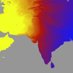
نسخه 6.1 از MCD18A1، یک طیفسنج تصویربرداری با وضوح متوسط (MODIS) ترکیبی Terra و Aqua با تابش موج کوتاه رو به پایین (DSR) است که روزانه با وضوح پیکسلی 1 کیلومتر و تخمین DSR هر 3 ساعت تولید میشود. DSR تابش خورشیدی تابشی بر روی سطوح زمین در طیف موج کوتاه (300 تا 4000 نانومتر) است و یک متغیر مهم در مدلهای سطح زمین است که به مسائل علمی و کاربردی متنوعی میپردازد. محصولات MCD18 بر اساس یک الگوریتم نمونهسازی اولیه هستند که از امضاهای چندزمانه دادههای MODIS برای استخراج بازتاب سطح و سپس محاسبه DSR تابشی با استفاده از رویکرد جدول جستجو (LUT) استفاده میکند. LUTها انواع مختلف بارگذاری آئروسلها و ابرها را در هندسههای مختلف روشنایی/دید در نظر میگیرند. محصولات DSR جهانی از MODIS و دادههای ماهوارهای زمینثابت تولید میشوند. جزئیات بیشتر در مورد روش مورد استفاده برای ایجاد دادهها در سند مبانی نظری الگوریتم موجود است.
باندها
باندها
اندازه پیکسل: ۵۰۰ متر (همه باندها)
| نام | واحدها | حداقل | مکس | اندازه پیکسل | توضیحات | ||||||||||||||||||||||||||||||||||||||||||||||||||||||||||||||||||||||||||||||||||||||||||||||
|---|---|---|---|---|---|---|---|---|---|---|---|---|---|---|---|---|---|---|---|---|---|---|---|---|---|---|---|---|---|---|---|---|---|---|---|---|---|---|---|---|---|---|---|---|---|---|---|---|---|---|---|---|---|---|---|---|---|---|---|---|---|---|---|---|---|---|---|---|---|---|---|---|---|---|---|---|---|---|---|---|---|---|---|---|---|---|---|---|---|---|---|---|---|---|---|---|---|---|---|
DSR | وات بر متر مربع | 0 | ۱۴۰۰ | ۵۰۰ متر | DSR کل لحظهای در روگذر MODIS | ||||||||||||||||||||||||||||||||||||||||||||||||||||||||||||||||||||||||||||||||||||||||||||||
Direct | وات بر متر مربع | 0 | ۱۴۰۰ | ۵۰۰ متر | DSR مستقیم لحظهای در روگذر MODIS | ||||||||||||||||||||||||||||||||||||||||||||||||||||||||||||||||||||||||||||||||||||||||||||||
Diffuse | وات بر متر مربع | 0 | ۱۴۰۰ | ۵۰۰ متر | DSR پخش لحظهای در روگذر MODIS | ||||||||||||||||||||||||||||||||||||||||||||||||||||||||||||||||||||||||||||||||||||||||||||||
GMT_0000_DSR | وات بر متر مربع | 0 | ۱۴۰۰ | ۵۰۰ متر | DSR کل در ساعت 00:00 به وقت گرینویچ | ||||||||||||||||||||||||||||||||||||||||||||||||||||||||||||||||||||||||||||||||||||||||||||||
GMT_0300_DSR | وات بر متر مربع | 0 | ۱۴۰۰ | ۵۰۰ متر | DSR کل در ساعت 03:00 به وقت گرینویچ | ||||||||||||||||||||||||||||||||||||||||||||||||||||||||||||||||||||||||||||||||||||||||||||||
GMT_0600_DSR | وات بر متر مربع | 0 | ۱۴۰۰ | ۵۰۰ متر | DSR کل در ساعت 06:00 به وقت گرینویچ | ||||||||||||||||||||||||||||||||||||||||||||||||||||||||||||||||||||||||||||||||||||||||||||||
GMT_0900_DSR | وات بر متر مربع | 0 | ۱۴۰۰ | ۵۰۰ متر | DSR کل در ساعت 09:00 به وقت گرینویچ | ||||||||||||||||||||||||||||||||||||||||||||||||||||||||||||||||||||||||||||||||||||||||||||||
GMT_1200_DSR | وات بر متر مربع | 0 | ۱۴۰۰ | ۵۰۰ متر | DSR کل در ساعت 12:00 به وقت گرینویچ | ||||||||||||||||||||||||||||||||||||||||||||||||||||||||||||||||||||||||||||||||||||||||||||||
GMT_1500_DSR | وات بر متر مربع | 0 | ۱۴۰۰ | ۵۰۰ متر | DSR کل در ساعت ۱۵:۰۰ به وقت گرینویچ | ||||||||||||||||||||||||||||||||||||||||||||||||||||||||||||||||||||||||||||||||||||||||||||||
GMT_1800_DSR | وات بر متر مربع | 0 | ۱۴۰۰ | ۵۰۰ متر | DSR کل در ساعت 18:00 به وقت گرینویچ | ||||||||||||||||||||||||||||||||||||||||||||||||||||||||||||||||||||||||||||||||||||||||||||||
GMT_2100_DSR | وات بر متر مربع | 0 | ۱۴۰۰ | ۵۰۰ متر | DSR کل در ساعت 21:00 به وقت گرینویچ | ||||||||||||||||||||||||||||||||||||||||||||||||||||||||||||||||||||||||||||||||||||||||||||||
DSR_Quality | ۵۰۰ متر | پرچم با کیفیت | |||||||||||||||||||||||||||||||||||||||||||||||||||||||||||||||||||||||||||||||||||||||||||||||||
شرایط استفاده
شرایط استفاده
دادهها و محصولات MODIS که از طریق LP DAAC به دست میآیند، هیچ محدودیتی در استفاده، فروش یا توزیع مجدد بعدی ندارند.
نقل قولها
برای کسب اطلاعات در مورد استناد به مجموعه دادههای LP DAAC، لطفاً از صفحه «استناد به دادههای ما» در LP DAAC دیدن کنید.
DOI ها
با موتور زمین کاوش کنید
ویرایشگر کد (جاوااسکریپت)
var dataset = ee.ImageCollection('MODIS/061/MCD18A1')
                  .filter(ee.Filter.date('2000-01-01', '2001-01-01'));
var gmt_1200_dsr = dataset.select('GMT_1200_DSR');
var gmt_1200_dsr_vis = {
  min: 0,
  max: 350,
  palette: ['0f17ff', 'b11406', 'f1ff23'],
};
Map.setCenter(6.746, 46.529, 2);
Map.addLayer(
    gmt_1200_dsr, gmt_1200_dsr_vis,
    'Total dsr at GMT 12:00');