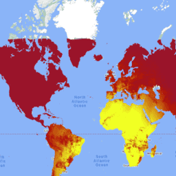
MCD18C2 نسخه 6.1 یک طیفسنج رادیومتر تصویربرداری با وضوح متوسط (MODIS) سطح 3 شبکهبندی شده با تشعشعات فعال فتوسنتزی (PAR) ترکیبی با وضوح متوسط (MODIS) است که روزانه با وضوح 0.05 درجه (5600 متر در استوا) با تخمین PAR در هر 3 ساعت تولید میشود. PAR تابش خورشیدی فرودی در طیف مرئی (400-700 نانومتر) است و یک متغیر مهم در مدلهای سطح زمین است که به انواع مسائل علمی و کاربردی میپردازد. محصولات MCD18 بر اساس یک الگوریتم نمونهسازی اولیه هستند که از امضاهای چند زمانی دادههای MODIS برای استخراج بازتاب سطح و سپس محاسبه PAR حادثه با استفاده از رویکرد جدول جستجو (LUT) استفاده میکند. LUT ها انواع مختلفی از بارگیری ذرات معلق در هوا و ابرها را در انواع هندسه روشنایی / مشاهده در نظر می گیرند. محصولات جهانی PAR از MODIS و داده های ماهواره ای زمین ایستا تولید می شوند. جزئیات بیشتر در مورد روش مورد استفاده برای ایجاد داده ها در سند مبنای نظری الگوریتم موجود است.
باندها
اندازه پیکسل 500 متر
باندها
نام
اندازه پیکسل
توضیحات
GMT_0000_PAR
متر
کل PAR در ساعت 00:00 به وقت GMT
GMT_0300_PAR
متر
کل PAR در ساعت 03:00 به وقت GMT
GMT_0600_PAR
متر
مجموع PAR در ساعت 06:00 به وقت GMT
GMT_0900_PAR
متر
مجموع PAR در ساعت 09:00 به وقت گرینویچ
GMT_1200_PAR
متر
مجموع PAR در ساعت 12:00 به وقت GMT
GMT_1500_PAR
متر
مجموع PAR در ساعت 15:00 به وقت GMT
GMT_1800_PAR
متر
مجموع PAR در ساعت 18:00 به وقت GMT
GMT_2100_PAR
متر
کل PAR در ساعت 21:00 به وقت GMT
شرایط استفاده
شرایط استفاده
دادههای MODIS و محصولات بهدستآمده از طریق LP DAAC هیچ محدودیتی در استفاده، فروش یا توزیع مجدد بعدی ندارند.
MCD18C2 نسخه 6.1 یک طیفسنج رادیومتر تصویربرداری با وضوح متوسط (MODIS) سطح 3 شبکهبندی شده با تشعشعات فعال فتوسنتزی (PAR) ترکیبی با وضوح متوسط (MODIS) است که روزانه با وضوح 0.05 درجه (5600 متر در استوا) با تخمین PAR در هر 3 ساعت تولید میشود. PAR تابش خورشیدی تابشی در طیف مرئی است…
[null,null,[],[[["\u003cp\u003eMCD18C2 V6.1 provides daily, 3-hourly estimates of Photosynthetically Active Radiation (PAR) at 500-meter resolution using MODIS Terra and Aqua data.\u003c/p\u003e\n"],["\u003cp\u003eThis dataset covers the period from February 24, 2002, to June 1, 2024, and is based on surface reflectance derived from MODIS observations.\u003c/p\u003e\n"],["\u003cp\u003ePAR, crucial for land-surface models, is calculated using a look-up table approach considering aerosols, clouds, and illumination geometry.\u003c/p\u003e\n"],["\u003cp\u003eAlthough V6.1 is no longer being produced and has been replaced by V6.2, it remains available through Google Earth Engine.\u003c/p\u003e\n"],["\u003cp\u003eThe data has no restrictions on use, sale, or redistribution and is provided by NASA LP DAAC at the USGS EROS Center.\u003c/p\u003e\n"]]],["The MCD18C2 Version 6.1 dataset provides daily, gridded estimates of Photosynthetically Active Radiation (PAR) every 3 hours, derived from MODIS Terra and Aqua data. It's a Level 3 product, available from 2002-02-24 to 2024-06-01, at a 0.05-degree resolution. Data is provided at intervals `GMT_0000_PAR` to `GMT_2100_PAR` at each three hour mark, capturing the total PAR. It is accessible via Google Earth Engine and has no restrictions on use or redistribution. The data has been superseded by a new dataset.\n"],null,["# MCD18C2.061 Photosynthetically Active Radiation Daily 3-Hour [deprecated]\n\n**Caution:** This dataset has been superseded by [MODIS/062/MCD18C2](/earth-engine/datasets/catalog/MODIS_062_MCD18C2). \n\nDataset Availability\n: 2002-02-24T00:00:00Z--2024-06-01T00:00:00Z\n\nDataset Provider\n:\n\n\n [NASA LP DAAC at the USGS EROS Center](https://lpdaac.usgs.gov/products/mcd18c2v061/)\n\nCadence\n: 1 Day\n\nTags\n:\n climate \n par \nradiation \n\n#### Description\n\nThe MCD18C2 Version 6.1\nis a Moderate Resolution Imaging Spectroradiometer\n(MODIS) Terra and Aqua combined Photosynthetically Active Radiation (PAR)\ngridded Level 3 product produced daily at 0.05 degree (5,600 meters at the\nequator) resolution with estimates of PAR every 3 hours. PAR is incident\nsolar radiation in the visible spectrum (400-700 nanometers) and is an\nimportant variable in land-surface models that address a variety of\nscientific and application issues. The MCD18 products are based on a\nprototyping algorithm that uses multi-temporal signatures of MODIS data to\nderive surface reflectance and then calculate incident PAR using the look-up\ntable (LUT) approach. The LUTs consider different types of loadings of\naerosols and clouds at a variety of illumination/viewing geometry. Global\nPAR products are generated from MODIS and geostationary satellite data.\nAdditional details regarding the methodology used to create the data are\navailable in the\n[Algorithm Theoretical Basis Document](https://lpdaac.usgs.gov/documents/106/MCD18_ATBD.pdf)\n\n### Bands\n\n\n**Pixel Size**\n\n500 meters\n\n**Bands**\n\n| Name | Pixel Size | Description |\n|----------------|------------|------------------------|\n| `GMT_0000_PAR` | meters | Total PAR at GMT 00:00 |\n| `GMT_0300_PAR` | meters | Total PAR at GMT 03:00 |\n| `GMT_0600_PAR` | meters | Total PAR at GMT 06:00 |\n| `GMT_0900_PAR` | meters | Total PAR at GMT 09:00 |\n| `GMT_1200_PAR` | meters | Total PAR at GMT 12:00 |\n| `GMT_1500_PAR` | meters | Total PAR at GMT 15:00 |\n| `GMT_1800_PAR` | meters | Total PAR at GMT 18:00 |\n| `GMT_2100_PAR` | meters | Total PAR at GMT 21:00 |\n\n### Terms of Use\n\n**Terms of Use**\n\nMODIS data and products acquired through the LP DAAC\nhave no restrictions on subsequent use, sale, or redistribution.\n\n### Citations\n\nCitations:\n\n- Please visit [LP DAAC 'Citing Our Data' page](https://lpdaac.usgs.gov/citing_our_data)\n for information on citing LP DAAC datasets.\n\n### DOIs\n\n- \u003chttps://doi.org/10.5067/MODIS/MCD18C2.061\u003e\n\n### Explore with Earth Engine\n\n| **Important:** Earth Engine is a platform for petabyte-scale scientific analysis and visualization of geospatial datasets, both for public benefit and for business and government users. Earth Engine is free to use for research, education, and nonprofit use. To get started, please [register for Earth Engine access.](https://console.cloud.google.com/earth-engine)\n\n### Code Editor (JavaScript)\n\n```javascript\nvar dataset = ee.ImageCollection('MODIS/061/MCD18C2')\n .filter(ee.Filter.date('2001-01-01', '2001-02-01'));\nvar gmt_1200_par = dataset.select('GMT_1200_PAR');\nvar gmt_1200_par_vis = {\n min: -236,\n max: 316,\n palette: ['0f17ff', 'b11406', 'f1ff23'],\n};\nMap.setCenter(6.746, 46.529, 2);\nMap.addLayer(\n gmt_1200_par, gmt_1200_par_vis,\n 'Total PAR at GMT 12:00');\n```\n[Open in Code Editor](https://code.earthengine.google.com/?scriptPath=Examples:Datasets/MODIS/MODIS_061_MCD18C2) \n[MCD18C2.061 Photosynthetically Active Radiation Daily 3-Hour \\[deprecated\\]](/earth-engine/datasets/catalog/MODIS_061_MCD18C2) \nThe MCD18C2 Version 6.1 is a Moderate Resolution Imaging Spectroradiometer (MODIS) Terra and Aqua combined Photosynthetically Active Radiation (PAR) gridded Level 3 product produced daily at 0.05 degree (5,600 meters at the equator) resolution with estimates of PAR every 3 hours. PAR is incident solar radiation in the visible spectrum ... \nMODIS/061/MCD18C2, climate,par,radiation \n2002-02-24T00:00:00Z/2024-06-01T00:00:00Z \n-90 -180 90 180 \nGoogle Earth Engine \nhttps://developers.google.com/earth-engine/datasets\n\n- [https://doi.org/10.5067/MODIS/MCD18C2.061](https://doi.org/https://lpdaac.usgs.gov/products/mcd18c2v061/)\n- [https://doi.org/10.5067/MODIS/MCD18C2.061](https://doi.org/https://developers.google.com/earth-engine/datasets/catalog/MODIS_061_MCD18C2)"]]